
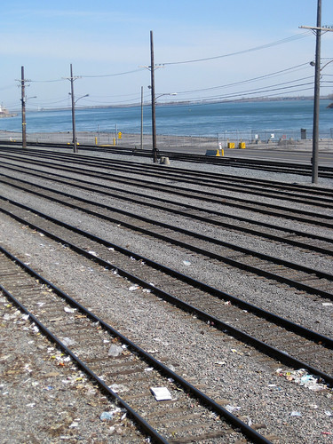
This is as close as it gets to waterfront access along Notre Dame Est, around rue Fullum. I don’t mean this as a critique – Condos and boardwalks alone do not make a viable city and Montreal was built on its port, industry and railways.
Meanwhile, Kate M at the Montreal city weblog gives readers an overview of the mounting criticism surrounding the Notre Dame and Turcot developments and points out that the issue is not limited to transit and urban boulevards vs highways and suburbs:
“Notre-Dame East functions to a large extent as an artery for the Port of Montreal and for the east-end refineries. Maybe we need to work on other ways of getting goods and materials to and from the port: making more use of the railways which already serve the port area would be a start.”
25 comments
Some cities get it right. This is vancouver’s DOWNTOWN waterfront:
http://www.youtube.com/watch?v=mhkjdx91g7c
If you go further east, there is parc promenade bellerive.
As Sid points out, Montreal has some nice waterfront which I really want to explore and blog about this summer. But the waterfront isn’t really a major destination around here, in comparison to Vancouver or even Toronto. In most of the central parts of the city, it is either inaccessible or out of sight, out of mind (the lachine canal and old port hardly count).
BTW, where is Vancouver’s port?
Well there is not really a good map online of where vancouver port is, so I tried to make one in google maps:
http://maps.google.ca/maps/ms?oe=utf-8&client=firefox-a&ie=UTF8&split=0&gl=ca&ei=ZDPZSbT8G5auNamTyfgO&hl=en&msa=0&ll=49.19741,-123.057175&spn=0.577921,1.235962&t=h&z=10&msid=113085744286927982099.000466d67d3c7b7c9cf00
Comparing Montreal to Vancouver in this way is really like comparing apples and oranges; the two cities have a history and a heritage so different, not to mention geography and topography. Montreal was Canada’s industrial capital when Vancouver was barely a blip on the Canadian map and Montreal’s role in developing all of Canada via the railway and our place in the history of the country as its economic motor for generations cannot be stressed enough. To state that Vancouver “got it right” is ignoring these realities.
It’s also worth remembering that English Bay is downtown Vancouver’s back end — the adjacent shoreline developed as an upscale suburb in the late 19th and early 20th centuries.
The waterfront along Burrard Inlet is just as industrial as the east end waterfront in Montreal. There’s no public access to the water east of Canada Place.
I find it sad that, despite already having all this rail in place, we still still apparently need an expensive and disruptive trench highway on Notre Dame to accomodate all the trucking and commuting.
Well I beg to differ that Vancouver to Montreal is apples to oranges.
When I grew up in Vancouver in the 1980s all the water around the downtown peninsula was industrial. All the gorgeous waterfront along False Creek was active pulp mills. The water was clogged with log booms and too polluted to swim in. What is now the towers of yaletown on both sides of the cambie bridge was storage for shipping containers with no waterfront access. Similarly the waterfront along coal harbour to the west of Canada Place was a giant train yard. Apart from the Bayshore Inn there was no access to the waterfront at all where now where are parks and seawalls. With the olympic village that is going in, the last bit of industrial waterfront in downtown vancouver has been reclaimed for public access, and I am sure that the lands to the east of the container port will one day follow. (Sorry this paragraph assumes knowledge of vancouver geography and history and may be deemed off-topic to a montreal blog, but it is a valid response to Christopher DeWolf’s post ).
I think a major reason the two cities differ is that Vancouver had 2 things things in the 1980s 90s and 2000s that it never had before, the same 2 things that montreal had in the 1960s and 1970s and has not had since:
1) Money
2) Vision
Ok I’ll solve the problem of vancouver geography specific references with another google map:
Formerly industrial waterfront opened to the public since 1970:
http://maps.google.ca/maps/ms?ie=UTF8&hl=en&msa=0&ll=49.294792,-123.092194&spn=0.072097,0.154495&t=h&z=13&msid=113085744286927982099.000466dad3942b6fc856e
20-30 years ago Montreal had more rail infrastructure than a newcomer could possibly imagine. Most of it replaced by housing, or simply removed, which means it’s going to cost a mega-fortune to build new rail systems. Montreal’s progression into the brave new world of the 21st century is often a sad stupid story unfortunately dominated by greed in uneventful short term projects, such as future slum neighborhoods, where some vision might have been a lot more practical and financially responsible.
Please explain why the Old Port – the cities biggest tourist destination and the Lachine Canal which has received over 4 billion dollars in investment between 1997 and today hardly count. Have you ever biked along the Lachine Canal? It is always packed – maybe its not a tourist destination, but its definitely a destination for Montrealers. Also, what is wrong the the access on Ile-Ste Helene and Ile Notre-Dame? What about the access throughout Ile de Boucherville Provincial Park right across from “beloved” Notre Dame boulevard. Then of course there are the 30 or so parks are access points in the west island along Lakeshore (Bord du Lac) like Waterfront Park and the Beaconsfield Yacht Club. Let’s not also forget the north shore with Ile de la Visitation and le Bois de Saraguay etc.
The sad part is the negative connotation you assume while only looking at one tiny segment of waterfront in the city and utterly dismissing without merit what we do have.
Just for fun:
Yaletown in 1982:
http://www.globalairphotos.com/large/BC/Vancouver/Downtown/1982/072/2
Yaletown in 2008:
http://www.globalairphotos.com/large/BC/Vancouver/Downtown/2008/460/2
GDS thank you for nailing it on the head.
Anyone who has ventured outside ville-marie/plateau knows that waterfront access in and around Montreal is not an issue.
To the Vancouver connaisseurs, did these paper mills close by themselves (bankrupt) or were they expropriated by the city?
To get access to the water, the city of Montreal not only needs to expropriate Molson (dozens of millions plus moving costs endured by Molson) but also push away one of the last remaining asset of that company in Montreal.
And we’re not even discussing expropriating Port de Montreal, which is doing very well thank you and has no plan but to expand its operations.
Le «Bord du lac» n’est guère accessible, il n’y a environ que 1% de zone en parcs, le reste est de la propriété privée, parce que seuls les riches (anglais) peuvent jouïr du lac (pollué par la rivière des Outaouais. Ha!).
Not to mention that GDS’s list doesn’t even include the Verdun/Lasalle waterfront, which merely stretches from Pont Champlain to the Lachine end of the Lachine Canal.
There is waterfront access in Vancouver east of Canada Place at Crab Park, which is accessed via Main Street, and, much further east, at New Brighton Park.
Randy, I agree with Edward: you’re comparing apples to oranges. You can’t compare a 400 year old island city, located on a river 1500 km’s distant from the Atlantic Ocean to a 100 year old mainland city, located on a bay just off the Pacific Ocean. The only thing they have in common is water.
Furthermore, you’re comparing the working stretch of the Port of Montréal to the luxury condo stretch of Vancouver. If you were to post photos of the Burrard Inlet, we’d see (as Christopher has pointed out) the same rail yards, cranes and lack of access etc. which are common to any port facility.
I’m a huge fan of places like Stanley Park, Wreck Beach, Granville Island etc., but I’m not a fan of the Condofront that has been built over the last 20-30 years. What little public space which has been set aside is subject to the control of the looming residents. It’s an OK place to go for a walk or a ride but it’s pretty much useless for anything else. The Olympic Village is simply a horrible mistake.
I think that future generations of Vancouverites are going to be asking themeselves why so much prime waterfront was given up to developers. Why were so many uninspired, similar-looking condos built and why, 30 or so years down the road, has the area not aged very well.
If you want to compare Vancouver’s waterfront to similar cities, try Seattle, San Fransisco, Sydney, Rio etc.
Samir and GDS – as I wrote in the post and in my following comment, I’m not trying to whine about poor waterfront access in this part of town. Any city’s shore line needs to be shared by industry, port activities, the public, and natural spaces. All of those uses are interesting and photo-worthy, and also open to critique (is the rail serving a purpose? can it be used more effectively or removed in the future?)
I’ve lived a block from the canal and use it as a bike route often. I like the space, but you can’t exactly hop in for a dip, or fish there, or even skip stones or watch the currents. So to me it dosent feel like waterfront. To me it feels more like a pleasant passage than a destination. Perhaps i am underestimating the old port – if you go to the tip of the piers, you can at least see the St-lawrence flow by.
Randy – thanks for the informative maps.
Read in the Sainte-Marie revitalization project plan that one of the goals was to make the waterfront of the neighbourhood “accessible”… then I walked over to where you took this picture (in a park that is basically only used to watch fireworks for free) and thought, how in the world, would they do that? Build a bridge across the train tracks and create a boardwalk?? You could but I doubt anybody would bother as the boardwalk would still have two barriers: crossing Notre-Dame + this theoretical bridge. It’s a shame the train tracks follow the river but that’s the way it is.
I had a rental car one weekend so I took my dog for a walk in that other park mentioned out east (in Tetraultville I think)… it’s really nice.
Leave industrial sites like Molson alone i.e expropraition will never happen. There are so many places already available to the larger population as noted in these responses. Lets work with what we have and leave the dreaming to the politicians.
Good point — we’ll probably need to keep railways intact in the near future, as they’re much more energy-efficient than cars, trucks and buses.
It is really hard to imagine what the powers that be will come up with next. There has been talk of light rapid rail between the airport and downtown for years. For a fraction of the consulting fees they could have greatly improved bus service which is badly needed and perhaps is the easiest interim solution.
I also find Vancouver much nicer now than when I was growing up there in the 70s and 80s, but I, too, find the new parts uninspired in places. I’m sure it will be nicer when the trees mature, but then of course the buildings will be old and I suspect it will still seem as an afterthought and a glorified towers-in-the-park kinda thing.
While Montreal cannot compete with the sheer lushness of Vancouver’s spectacular parks such as Stanley and Queen E., I actually prefer the Old Port and the Lachine Canal with vestiges of a very industrial past sticking out here and there. I also prefer the more urban design of Montreal’s neighbourhood parks with trees and pedestrian paths to Vancouver’s soccer-field-with-a-few-bushes-at-one-end approach.
But I still miss the ocean and real mountains, sigh.
Let’s not forget we have PRIME waterfront land at Cite du Havre and few private developers have taken advantage of that incredible land. The ones that have, have built awful condos, sadly never taking a cue from Habitat perhaps opting to build architectural gems. On a another note, I have confidence that we will get a substantial river front park on the land mass adjacent to Cite du Havre.
i like notre dame as it is.
could use a touch of repaving (couldn’t the whole city). but the part from dickson to honore beaugrand is a marvelous stretch from an engineers perspective.
it is a respectable artery, quite quick and respectful to the city’s industrial heritage.
Just a note to Todd – Montreal is in no way located 1500km distant (by river) from the Atlantic. 1500km from Montreal, via the river and out to sea, takes you almost exactly to the northern tip of Newfoundland!