
This post has been slowly coming together since I asked “what is a neighbourhood?” in March. I started to try and define what neighbourhoods make up the Plateau, partially shed some light on the debate about the boundaries of Mile-End.
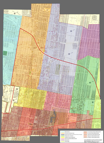
You don’t have to scratch the surface very deep to find out that the Plateau Mont-Royal borough is an amalgamation of 4 historic villages. But, upon further examination, it turns out even that is an over-simplification.
I stitched together the map above as best I could from 9 pages of an atlas published in 1907. Then I coloured in the different villages and wards and added the outline of the current Plateau Mont-Royal limits (Source: Bibliothèque et Archives nationales du Québec. Hopefully they come after me for this!). Another atlas from 1879 was also used to figure out some of place names that had already been annexed to Montreal in 1907.
So here’s what I’ve figured out so far:
In 1792, the City of Montreal limit was expanded to a distance of “100 chains” (about 2km) around the original fortified city. Along Saint-Lawrence Blvd (as it was called back in those days), the limit fell between Napoeon and Duluth. Saint-Lawrence Boulevard was the only North-South axis which reached all the way to Rivière des Prairies.
Le Coteau-St-Louis (Blue) was one of the first villages founded north of Montreal in 1846. It grew around the Chemin des Carrières, which began at the Belair Tannery (which I believe would have been on the corner of Sanguinet) and wound its way northwards to various stone quarries. This street that is now called Gilford in the Plateau, but retains its old name above the tracks in Rosemont.
The area around Laurier park (which was a quarry at this point) had already been inhabited for decades by “pieds-noirs” quarrymen, whose drinking, singing, feuding and fighting habits have been described by Coolopolis. As the quarries were depleted towards the end of the century, the village ran out of cash and was annexed to Montreal in 1893. Triplexes began to crop up along the narrow streets, alongside the old cottage-style dwellings, but a few of the latter are still around.
St-Louis-du-Mile-End (Orange) split off from Coteau-St-Louis in 1878. The dividing line was between Sanguinet and Drolet, for those of you who want to argue about where Mile End’s boundaries lie. The railway had opened the same year with a Mile End station at Bernard and Saint-Lawrence. The station is 1 mile north of Mount-Royal avenue, which was the southern limit of the village, and which may or may not have anything to do with its name.
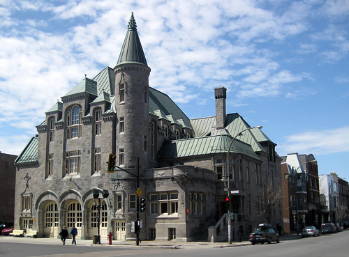
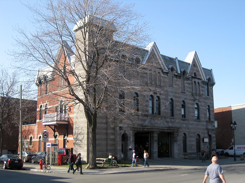
The Saint-Enfant-Jésus-du-Mile-End church, on St-Dominique and Saint-Joseph, was the heart of the community, at least until the early 1900ds when Jewish, German and Polish immigrants set up shop and built their own places of worship. In 1905 the the town built an extravagant, chateau-like hotel-de-ville just across the street, which is now a fire station.
During their earliest years, the Montreal Canadiens held their practice at the Mount-Royal Arena, between Clark and Saint-Urbain.
I was surprised to learn that the village extended far north of the railway up to present-day de Castelneau street. Also the area around present-day Jean-Talon market must have been Irish with street names like Erin and Shamrock in 1907 (perhaps this will be the subject of a future post). St-Louis du Mile End was annexed in 1909. At that time it was the 3rd largest city in the province of Québec.
St-Jean-Baptiste (Yellow and Pink) was founded in 1860, the same year as a horse-drawn tram began to serve Saint-Lawrence blvd. The village grew up around the busy commercial streets of Rachel and Saint-Laurent. At the intersection of these two commercial streets was the St-Jean-Baptiste market (now Parc des Amériques). Farmers would arrive with their horses and wagons full of produce on Sunday night and camp out in the market to have the best spots on Monday morning.
The town also installed a toll booth on Saint-Lawrence and Mount-Royal which must have been quite profitable as this was still the only North-South axis on the island. This village was annexed in 1886 (it was already part of Montreal at the time this map was drawn, and had been split into two wards: Saint-Jean Baptiste (yellow) and Duvernay (pink)).
Village De Lorimier (Green) stretches east from Papineau to Iberville, was originally called “village cote-de-la-visitation” in 1870. In 1895 it was was renamed and re-branded as an elegant, tree-lined suburb with wide avenues and paved sidewalks. They even built a fancy town hall in 1901 which also became a fire station after the village was annexed in 1909.
For me the biggest surprise of this whole process was discovering that that the eastern edge of the borough was originally the most high-class. My parents have lived around the corner from here for the past 15 years and I have found it to be the most low-key, affordable, family-centered, and generally un-trendy part of the uber-hip Plateau. Perhaps because few people besides savvy real-estate agents even realize that the Plateau technically goes as far east as Iberville.
So those are the famous 4 villages. I’ve found that gathering up info on the neighbourhoods that constituted the Southern edge of the borough has been more of a challenge.
The Cote-à-Baron, seems to have been the French answer to the Golden Square Mile. It picked up where the Mile left off, lining Sherbrooke street with mansions from DuRocher to Amherst, through the Saint-Lawrence, Saint-Louis and Lafontaine wards.
The Saint-Louis-de-France area (Red) was the hub for francophone bourgeois back when Outremont was still farmland. At the end of the 1800ds, the area around carré Saint-Louis was home to lawyers and judges and stabled some of the finest horses in the city. Each day these horses would be harnessed to carriages and the wives, dressed to the nines, would parade downtown to the courthouse to pick up their husbands after work.
I have heard that, in the 1970s, there was a short-lived attempt to eradicate the bourgeois flavour of carré St-Louis by turning the fountain into a sandbox, but I haven’t tracked down any photos to confirm (if you have any please, please send them in!)
—-
Anyhow, this has obviously been just a superficial history of the Plateau in an attempt to get an overall picture of how all these puzzle pieces fit together. There are lots more sites with lots more details (not to mention living memories!).
A centurly later, some of these boundaries seem indistinguishable to me (the historical city limit between Napoleon and Duluth and the changes in urban form on either side of Papineau) while others like Mount-Royal avenue are intuitive, but surely all have influenced the urban form.
Even more than I originally imagined, the Plateau is a patchwork of places, or perhaps, as historical boundaries are blurred and forgotten, it has become a mutt of a place. And a mutt, with all its inherent diversity, may not always the most beautiful of creatures, but it tends to be the most resilient.
20 comments
Great map, great research, I love it.
The Mont-Royal Arena (corner Mt-Royal and St-Urbain, where the Provigo sits now) was the Canadiens’ home arena, not just their practice facility. Other events were held there too, including a concert by the opera superstar Caruso sometime during the 1930s.
Great post!
Ah, a realtor’s map. It should be understood that far from being absolutely accurate maps, those maps show subdivisions that are most often real-estate agents’ wet-dreams. For example, just southeast of the Mile-End station, one will see that the Carmélites’ monastery (on Carmel Avenue) is heavily sliced-and-diced to a death of a thousand (paper) cuts…
This is why many streets don’t show-up, they were eventually “dug through” some of those lots (most of which are vacant, it should be noted), and other planned streets (like St-Just in Outremont) were simply subdivided over (east of Outremont).
What a fantastic post. Thanks for doing all of this research and putting together such a well-organized article– I have always wondered where the boundaries lie for the ME and this is as good an argument as any, surely!
Those maps are not always very accurate. For instance there are a lot of buildings and streets in what is now Laurier park. I don’t think those were all razed to make the park, but the maps were just drawn after plans by realtors that never materialized. It’s funny to see how many streets names have been changed from English to French, in my part of town (Petit Patrie). Huntley, Dufferin, Sherbrooke Avenue, Shaw, Rossland. All streets that don’t exist anymore uner those names. I’m curious when those name changes where made, but too lazy to do research.
The map is a bit confusing because in 1907 most of the land was parcelled out but not actually built upon. If you look at the highest resolution, you can see the individual buildings coloured in pink and yellow. The building density is actually quite low as you go North.
Also, the pages of the atlas didn’t quite fit perfectly together, so some streets seem weirdly aligned…
Really great post. So much of our neighbourhoods and villages have changed over time that no wonder everyone has a different opinion over boundary lines. I wonder if other cities have had as much change as Montreal. Probably.
Great post…and I have to say that changing street names infuriates me for some reason!
And now I’m angry…hehe…but seriously, it does.
Thank god we stopped the Ave du Parc change.
I do remember when Carré Saint-Louis had a sandbox and some other down-at-heel park stuff in the centre. Then the city found that great fountain hidden away in some warehouse or other and installed it. Many of the trees, of course, had been there throughout. But I haven’t any pictures.
Oh, and a few other details: there’s a Mile End street, but it’s up just north of Jean-Talon tucked in east of the railway line that goes to Parc metro station. I don’t know why it’s so far from the neighbourhood we now know by that name. (And of course “Mile End” is also the name of a London neighbourhood and Tube station, although I’ve never found a direct link between the two.)
Saint-Louis-de-France: the original church was on a plot of land between Laval and Hôtel-de-Ville, north of Roy. There’s another building of vaguely convent-like aspect there, only unusual in that it has absolutely no sign outside saying what it is. The church burned down and another church of the same name was rebuilt on Roy east of Saint-Denis. (I can’t quote you chapter and verse on this, but I asked some women of vaguely nun-like aspect that I saw coming out of the Laval Street building, and they told me about it.)
and you might enjoy this Coolopolis entry if you haven’t seen it:
http://coolopolis.blogspot.com/2009/01/des-carrieres-street-panoramas-this-was.html
I uploaded the full-sized map – took me a long time. Fascinating. There are parks that have never been built (the big Delormier park) and others that exist that aren’t on the map (the real, small Delormier park between Chabot and Bordeaux – the latter had a different name in the eastern Plateau.
Drake, while I agree that avenue du Parc was a victory for popular will (from nationalist francophones to some allophones who refer to it in English), and while I agree about the importance of historical record, I am certainly not “infuriated” by most name changes. A lot of the original names “Atlantic, Pacific” were very generic, and had nothing to do with the particular neighbourhood or even Québec society. Shamrock Street has been retained, so much the better, but you wouldn’t want anything representative of the huge wage of Italian immigration around there? Or the Latin American presence commemorated by the small park at Bélanger an de Chateaubriand? (Many Latin-American friends want it to become Parc Allende with a monument to the murdered president and the many immigrants and refugees who arrived here from the Southern Cone dictatorships in the 1970s and who have had such an impact on Québec society.
To say nothing of the dearth of women…
I too remember the sandbox at Carré St Louis. I lived across the street in the late 70s when it was home to drug dealers, hippies and anarchists. The sandbox was used by the dogs and cats – there were only a few kids in the neighbourhood.
Great post.
Lot’s of great work there, Allanah! And for once I pretty much agree with what everyone is saying, heh. Irish community in the north end? Fascinating! I would love to see those old neighborhoods remembered in some way, a plaque in a park, or something in the sidewalk indicating a border, or even a notorious incident, from once upon a time (Coolopolis would have an extraordinary archive for that.)There is a lush history throughout the districts of the city and it would be wonderful to see it brought forward. I am even in favor of renaming streets were it to have some kind of local cultural/historical significance (hopefully we are beyond naming everything after dead politicians whose impact on that particular place is probably nil).
I want more!
I like how St. Viateur is transcribed on the map as “St. Viateur Street or Avenue.” I guess they hadn’t decided on the generic yet. Another interesting thing is that what is now known as St. Viateur East was once named Lauretta Avenue.
Also, take a look at the small square where Laurier metro is now. Was it ever built?
Neath, there were enough Irish Catholics in Mile End at the beginning of the 20th century to build St. Michael’s Church on Saint-Viateur in 1914-15. It may be the only monument to their presence there, but it’s a massive one.
Kate M.,
The Saint-louis-de-france church that burned down at the corner of Roy and Laval was pretty massive. It went all the way back to the “covent-like” building still there today.
That probably was the presbytery.
This is what the church looked like before it burnt:
http://bibnum2.banq.qc.ca/bna/massic/detail/5-20b-c.jpg
-X
PS: Thanks to last sunday’s Jane’s Walk held by Bronwyn Chester, Aline Grenon and Roger Latour for making me look clever!
Thanks for this post, especially that it is in English as my French is limited. . I am researching my ancestry and some of them were living in Coteau St. Louis during the 1800’s. My great great grandmother was married at the church of L’Enfant Jesus – Mile End. As an American of French Canadian descent, I am thrilled to be connected to such a beautiful area.
The old Saint-Louis de France church (north side or Roy between Laval & Hôtel-de-Ville) was considered one of the most beautiful in Canada when it was inaugurated in 1897. The building still standing on Laval was indeed its rectory, & today is the residence of an order on missionary nuns. Saint-Louis de France in its heyday was the home parish of Montreal’s old French-Canadian elite, since dispersed, who lived on Laval, Cherrier, Carré Saint-Louis, Sherbrooke, etc. (Another one of their hangouts was the Fusiliers Mont-Royal armoury, which is still there on the south side of Pine between Henri-Julien & Drolet). The church burned down in 1933. By that time the demographics around St. Lawrence Boulevard had altered & there were hardly any Catholics living near the site, so the decision was made to rebuild farther east, corner of Roy & Berri. This explains that strange feeling you get on the Main between Sherbrooke & Duluth, i.e., how come I’m in a neighbourhood in the middle of Montreal & there’s no church? The parish was merged with Saint-Jean-Baptiste (Rachel & Henri Julien) a few years ago & the church sold to a Latino evangelical group.
As for Mile End Street, it’s a reminder that the old village of Saint-Louis du Mile-End (1878-1909) was much bigger that today’s Mile End neighbourhood & indeed extended to slightly north of Jean-Talon.