
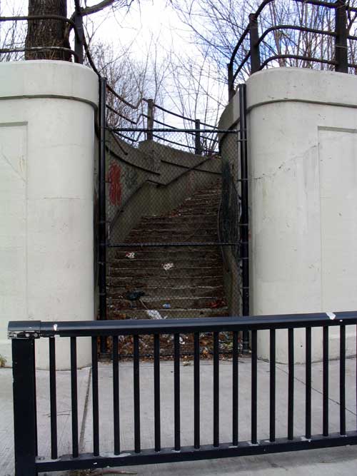
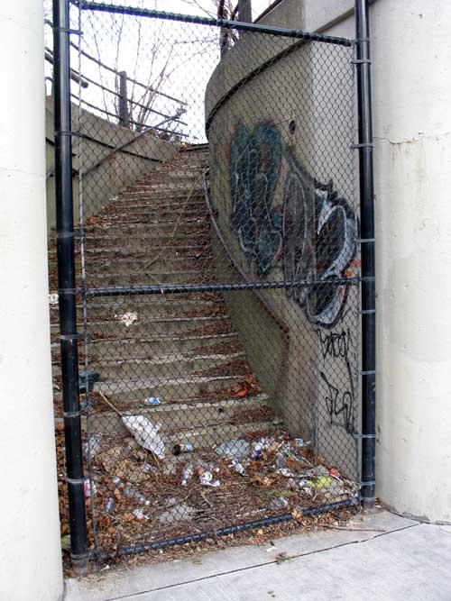
This enigmatic and forlorn stairway cuts through the retaining wall of the railway overpass crossing Dupont Street where it meets Dundas Street West and turns into Annette Street. A little historic investigation reveals that the old West Toronto CP passenger station (demolished in 1982, in orange on map below) was just along the tracks from here, though this stairway (red dot below) was not the main entrance. It’s likely that this was an entrance/exit to the southern end of the CP station’s platforms, allowing easier access to the important historic service into Union Station.
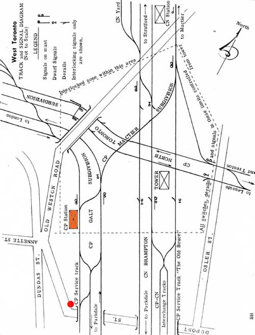
Map of track and street layout in 1961 with the CP station in orange and the stairway at the red dot (original map from Old Time Trains here)
Those of you wondering what Old Weston Road is doing connecting into the Annette/Dundas/Dupont intersection may be surprised to know that up until 1983 (when the venerable old bridge was demolished) Old Weston Road bridged the tracks at this point enabling a very quick and easy trip to the north avoiding the congestion of the Keele/Dundas intersection and underpass.
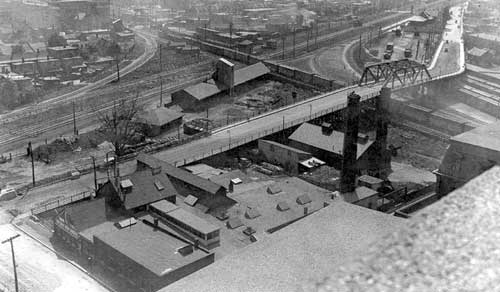
The Old Weston Road bridge in 1920, with the CP station in the top right corner (from Old Time Trains here)
The Old Weston Road bridge in 1898, with an earlier CP station and platforms (from Old Time Trains here)

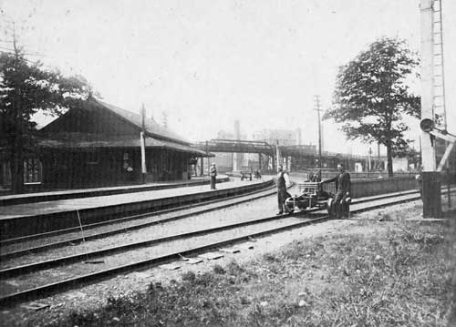
CP station and platforms in 1957 (from Toronto Public Library virtual exhibit here)
In any case, this vestige of a past age is a reminder of the reversal of transit connectivity the city suffered with the “modernisation†of its transportation infrastructure. Where once the Junction was connected by both streetcar and passenger rail to the rest of the city, it now suffers from disconnect, clinging by a key bus route over a former streetcar route to Dundas West Station. Optimists will be happy to know that the proposed airport rail connection is intended to use this railway line, but as far as I know, the Junction is an unlikely location for a new station since even if the line is built, a stop would no doubt be located at Bloor where the current GO Transit station is (and a subway interchange could be made), and unfortunately the Junction is closer than they would like to have the next station – all the more reason to use a Light Rail (LRT) or other electrified option, which allows for much easier acceleration and stopping and so closer stations.
Even without the best of transit, a new development by Options for Homes is in the works on the old Canadian Tire site south of the tracks off Keele Street north of Dundas Street West recently profiled in a Toronto Star article (see here – PDF) – the reinvention of the Junction continues, and for the community, it can’t happen fast enough.
**Edited after an original mistake regarding the new development was pointed out by Josh in the Comments**
Adapted from an original post on bricoleurbanism.org

13 comments
There is a similarly fenced in set of stairs that go up to the rail bed where the tracks cross over Logan Avenue. I’ve always wondered if there was at one time a train stop up there.
The link to the new Junction condo development is rather out of date. That project (as far as I can tell) fell through a number of years ago – the one being contemplated now is at http://www.optionsforhomes.ca/content.php?parentID=30&childID=19&childType=content
Josh, just updated the story with regard to your comment on the mistake on the developer and the project in question – thanks for your input.
Speaking of Josh, I’m also Josh. Thanks for the really interesting article. I have walked through there and wondered about that intersection. Great post on the Four Seasons parking lot, too.
Great post. I lived in that area for a long time and often wondered how it got to be the way it was.
I’m still hoping the West Toronto Rail Path gets going. Maybe one day those lost stairs can be used again.
I walk past both those stairwells each and every single day and have always wondered what the heck they were for.
This was a great article. I live in the Junction and I wouldn’t make anywher else my home. It’s got big things coming to it, I’m telling ya!
A bit of a diversion, but there is a group working to save/restore the old Mimico Station, their website is http://www.mimicostation.ca/ It would be nice to see this one preserved.
Interesting post. I remember exploring the CN Station (at top of the map) around ’99 or so. It was badly fire-damaged at the time, and has been demo-ed since. The embankments for the Old Weston Road bridge were still in place at the time. I’ll see if I can dig up any photos.
Paul.
It’s interesting to note that the stair’s presence has been maintained in the recent renewal of the retaining walls (note white concrete)–there’s evidently some token investment in its continued existence (I hope)…
As regards the supposed “upkeep” of the stair – the white concrete is actually painted white, not new concrete. I believe it was painted at the time that a local school did murals along the concrete walls of the underpass several years ago. If you look closely in the photos you can see the line where the paint stops. Not sure of the pedigree of the concrete work and overpass – there might be a date impressed on them somewhere but I haven’t noticed it yet.
I noticed the “1925” date underneath today. (However, I believe the whole reconfiguration of the Dundas/Dupont/Annette/Old Weston intersection–triangular traffic-island park and all–is 1930s, as is the present configuration of Dupont, knitted together out of several streets…)
I often admired that station while travelling on the Go Train and over a couple of years I witnessed its demise. There are many buildings like this that are part of our railway and transportation history. Before the parking lot was built for the MTCC, you could walk up on the plateau by the roundhouse and there were all manner of interesting relics there – all gone now. Even the Wychwood barns barely made it. The old gas station at Windermere and Lakeshore is perhaps the most depressing example of the general apathy towards our past.
I was recently doing some research on Dupont St.and came across your site.
Enjoyed it a lot. Love the map.
Does the map pre-date the underpass connecting Dupont, Dundas, Annette. It sure looks like it.
Printed the map and showed it around work, since I work in the Junction area (38 years). It’s amazing how few people in the area even know about this. To most folks, the underpass has always been there. If I come up with any ways to expand or improve, will be glad to help.