
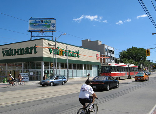
Mimico, one of Toronto’s outer streetcar suburbs
As Toronto begins detailed planning and consultations for Transit City, it is also looking to revitalize urban and suburban arterials. It may herald a new era of streetcar-orientated development.
Streetcar-oriented development really isn’t a new phenomenon, though it has re-asserted itself in several US and European cities where modern light rail and even heritage and modern streetcar systems have foster this kind of built form . Horse-drawn streetcars, with low fares and frequent service first allowed people to move to “suburbs” outside the city centre. Electric streetcars, introduced to Toronto in 1891, increased the speed and range of public transport and resulted in once-distant places to quickly become bedroom communities for the city, such as North Toronto, the Beach or Mimico, or even become industrial centres in their own right, such as New Toronto. These “suburbs” were still compact, dependant on the streetcar service as their lifeline, with stores and apartments in two and three storey buildings lining the routes.
Toronto’s growth followed this basic pattern of development until the car-centric community of Don Mills was built in the early 1950s with its own shopping mall and curvilinear streets. Single-use zoning, either through insular subdivisions of detached houses or massive high-rise rental towers, dominated the new, car-centric suburbs of the 1960s through the 1990s.

Urban Structure Map, Map 2 from Toronto’s Official Plan. Brown strips indicate Avenues
Transit City, in conjunction with the Official Plan, aims to take Toronto back to the future in transit and urban form. The new lines are particularly suited to the Avenues plan (shown above), which aims to bring mid-rise development to suburban arterials, while preserving existing neighbourhoods. The subways have been very effective for promoting high-density development, particularly along Bloor Street as far west as Etobicoke and as far east as Victoria Park.
We have seen subway-orientated development, particularly on the Yonge Line up to North York Centre. From Bloor Street northward, clusters of highrises surround many of the subway stations — the massive rental and new condo towers at Yonge and Eglinton and Yonge and Sheppard would not have been likely had it not been for the subway (some of Washington DC’s inner suburbs like Arlington are other good examples of subways fostering high density development). Yet places like North York Centre, served by two subways and full of condos and office towers built haphazardly in the last twenty-five years, can have an inhuman scale and feel.
On the other hand, streetcar-oriented development is typically made up of mid-rise buildings surrounded by established residential neighbourhoods. The Avenues and Centres seek to protect established neighbourhoods, directing growth to designated areas, bringing more people closer to arterial roads and nodes, where access to shops, services and better transit will be made available.
The Avenues stretch across most of the existing streetcar lines, such as Queen, College, Gerrard East and Lake Shore Blvd through South Etobicoke. Outside of the existing “streetcar suburbs” the Avenues stretch along many suburban arterials, such as Sheppard, Eglinton, Wilson and Kingston Road. Redevelopment would be slow, but deliberate, to bring buildings to the street, provide a more comfortable and social environment for pedestrians, and help reach Toronto’s goal of accommodating 1 million more residents within its boundaries.
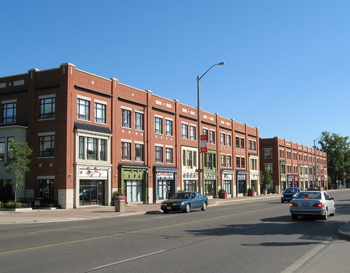
What Avenues-type development might look like. This example is Port Credit in Mississauga
Transit City, for the most part, reflects the aims of the Official Plan. Four of the Transit City routes (Eglinton-Crosstown, Scarborough-Malvern, Sheppard East and Waterfront West) have at least half their routes on corridors designated for streetcar-oriented development, Eglinton with 75% of the route so designated). Unfortunately, though, other streets ripe for intensification and busy transit corridors, such as Wilson (one of the first Avenue studies completed), Lawrence East and Kingston Road south-west of Eglinton, have been overlooked by Transit City.
Finally, through its close association with Toronto’s progressive development policy, we see that Transit City is closer to a streetcar than light rail, with the exception of the underground Eglinton route. This is fine, and will bring more reliable and attractive transit to many Torontonians, but it serves a different purpose than the LRT lines that you see elsewhere in North America, providing rapid transit in separated corridors, often away from where people live and work. The lines will be great for neighbourhood revitalization and addressing demands on some of the busiest corridors, less so for moving people quickly over longer distances. This is where subways and regional rail come in.

28 comments
I stood in front of that Mimico Value Mart for 40 minutes on Saturday waiting for the Eastbound car to come. Made me vow never to live in a streetcar suburb.
I really think a balance needs to be found between providing a local service (that helps foster “avenues”) and provinding a slightly faster limited-stop service that helps get people around this increasingly mega city of ours.
As it stands, I worry that Transit City will offer too many “local” stops and will be prone to the same bunching and unreliability as found on all our streetcar lines (including those with ROW’s like Spadina).
We need Transit City to use slightly more of the LRT philosophy which offers less stops, but more reliable and faster service. People don’t mind walking a bit further as long as the service warrants it. It’s certainly a trade-off, but as it stands I think we are erroring in treating our streetcar lines (present and future) like bus routes on rails.
Nice article as always Sean!
Sean wrote: “Finally, through its close association with Toronto’s progressive development policy, we see that Transit City is closer to a streetcar than light rail …”
That’s news to me. I thought Transit City was about building the network of rapid transit that this city desperately needs, at a price that it can afford.
In the end, transit exists to move people where they need to go. At $18 billion, I should hope that Toronto is getting a serious transit system — not to mention one that will provide a serious and attractive alternative to driving — rather than an attractive prop for a pleasant neighborhood. If the only thing we’re getting is 120km of new streetcar lines, it’s a massive waste of money.
Also, it’s odd that you would suggest that subways and regional rail are better for moving people quickly, since virtually everyone I know who is in favor of LRT is also opposed to building new subway lines.
Jason
Every indication is that Transit City wil not operate like a streetcar, with stops 400-500 metres apart. I think the streetcar network is fine with its current stops, though some should be removed for efficiency sake (the westbound stop at Victoria before Yonge — on Queen and King — is only 75 metres away, for example).
The places where TC is going to go will HAVE to be further apart since only one or two streets hit the najor arterials. I think the grid of the inner burbs will help make sure spacious stops will happen.
Matt,
There’s a few stops on the existing streetcar network that I would trim as well. Victoria Street at King, Queen (and once the Metropolis construction is complete), Dundas, as well as King and Queen at York, and Queen at Simcoe.
—
Transit city, as I argued before, is a hybrid concept, but when it comes to the Avenues plan, acts more like a streetcar in terms of fostering streetcar-oriented, low to mid ride urban development, which is exactly what many suburban neighbourhoods need. It exemplifies the interesting nature of the plan the city is working with now.
I’ve seen plans for wider stop spacing of 400-500 metres, which would be optimal, IMO, but the proof will come with the upcoming EA meetings and detailed plans. Also, all-door loading and median running will help, so we’re not talking Queen Street here, though Steve Munro has found problems with management even on routes 509 and 510, so there’s always a risk that the TTC could muck up the operations.
We already have a basic network of subways in place to move people quickly over long distances – the Spadina Subway, for example, serves a very different purpose than a Jane Transit City line. The Eglinton line, for example, has all the hallmarks of LRT as well. I also think that now that we have embraced streetcars/LRT again, we can look at some other forms of transit that have been ignored. The next tool that has been overlooked, I think, is the GO Transit corridors, which could be used for a semi-frequent, all day rail service like those in Europe.
Using some of the current subway stations as guides (approximate):
King to Queen 400 m
Dundas to College 500 m
St. Clair to Davisville 1 km
Eglinton to Lawrence 2 km
Spadina to Bathurst 600 m
Dufferin to Ossington 800 m
Keele to High Park Ave. 500 m
Runnymede to Jane 700 m
I think that 500± m apart is a good guideline. Anything less would slow it down too much. 1 km apart would be the maximum.
Sstreetcar-oriented, low to mid ride urban development, which is exactly what many suburban neighbourhoods need.
What does this mean? Is your idea that streetcars will help promote multiple dense nodes within barren corridors because their stops are more frequent than subways?
That’s news to me. I thought Transit City was about building the network of rapid transit that this city desperately needs, at a price that it can afford.
And I thought it was about skipping any public consultation in order to adopt a plan whose first priority is to make sure a streetcar runs through every ward. In other words, it’s safe to say that, given widely different understandings, Transfer City cannot correspond to what everyone thought it was.
I talked to Adam Giambrone about this once and he told me he didn’t expect stop placing to be much different before and after Transit City. It was at a party, so maybe he didn’t understand my question right, but I think he did.
As Matthew mentions, stops on the surface Transit City routes will very likely be around 500m apart, in order to provide a decent service speed for longer trips. The TTC is presently studying variations in signalling technologies, and will likely design a signalling system that more closely resembles that in the subway (in terms of operations, not aesthetics). Also, the TTC will likely use different versions of the new light rail vehicles on the Transit City lines, so those operating on ‘streetcar’ routes will resemble those we have now, while those running on TC lines will be longer, and with a cab at each end to eliminate the need for loops.
~500 metre stop spacing is, I think, a very good compromise; on the one hand, it is close enough for all properties with frontage on the street to be within 250m of a station (the golden rule for transport engineers is
Disparishun:
What does this mean? Is your idea that streetcars will help promote multiple dense nodes within barren corridors because their stops are more frequent than subways?
The presence of streetcars in the median will help to attract many people to the street and make it easier to provide transit and pedestrian-friendly streetscapes as what are called for in the Official Plan. Transit City is by no means perfect, but this would be harder to do with stops 1-2 kilometres apart. There’s a pychological aspect – rail-based transit is seen as superior to bus-based transit by many people.
Very few people would argue that most Transit City lines will do the same thing as a subway, and perhaps in a few cases, other modes of transit could make more sense (for Sheppard East, for example, I would probably take the subway as far as Vic Park and build a better transfer facility at that new station). It will be (as long as the TTC manages them properly) a faster, more attractive option than the local buses, and is only a part of a strategy to urbanize the inner suburbs.
In theory, it’s very well to say subways and GO Transit are the solution for travelling long distances quickly. In practice, the inner suburbs have lots of pockets of people along major roads that are 5-8 km from the nearest subway/GO station. (5-8 km is 20-30 minutes at typical downtown streetcar speeds, 10-15 minutes at subway speeds.) With many commuting downtown or to other burbs, I’m sure the average trip length on Transit City lines will be substantially longer than on Queen or Spadina.
Stop spacing will be one of the hardest parts of the Transit City scheme to get right. I don’t think anyone expects stops 1-2 km apart, since the faster travel time would be negated by longer walks. But if it’s designed as a local neighbourhood streetcar, it will be too slow to be an attractive option for commuters, and may not spur much redevelopment at all.
Stop spacing is usually dictated by the way a neighbourhood is built. In the suburbs, a common arrangement is to have a grid 2km on the side (this is the 1.25 mile spacing of concession roads that the British Army left to Ontario — they make nice 1000 acre squares). Often, but not always, there is a road at the half-way point, or roughly 1 km, between the major arterials. Some are straight, some are rather windy, some are discontinuous. These are always transit stops for obvious reasons.
Put one more stop at the midpoint between these mini-arterials, and you’re down to 500m as many have suggested.
There will always be exceptions to suit the situation on the ground. If there is a major intersection, the route will probably stop there because it will also be a significant origin/destination.
As for stops people would love to kill off, I don’t agree with all of the choices listed above. Queen and Victoria, for example, serves St. Michael’s hospital. This keeps coming up as if we could revolutionize transit if only we killed off zillions of unneeded stops when in fact the number is quite small. Fix the traffic lights that stop cars even when there is no need to do so.
Andrew: the $18 billion figure is actually for MoveOntario 2020 as a whole. Transit City is $6 billion (still a significant third of all announced capital transit expenditures).
I’m glad that transit is now being conceived of in terms of land-use modification, since it’s probably the most powerful non-zoning tool that cities have in their arsenal. Just as the suburban areas of Toronto and especially the outer-ring regional municipalities have been shaped by autocentric transportation infrastructure, so have the inner neighbourhoods been shaped by their transit. It’s no coincidence that Yonge and Queen Streets downtown have been major commercial strips, and transit corridors, for a hundred years. This plan really has the potential to encourage exactly the kind of development that the city wants along its avenues: not necessarily just dense nodes at major intersections as with subway stations, but also long strips that encourage an active pedestrian realm and efficient, human-scaled built form. The areas where I am most excited to see transit-oriented development are along Eglinton in Scarborough and in Leaside along Overlea Boulevard. In the former, there is plenty of commerce already and acres of developable parking lots, not to mention that the line comes within a kilometer of 100 apartment buildings. There is a similar situation on Overlea, at a smaller scale.
Naturally, this development can’t happen along the length of every route, but I think Transit City strikes a good balance between getting people through neighbourhoods, and helping people stay in them. How effective Transit City will be at catalyzing development will of course depend on stop spacing, loop/siding location, service frequency and such.
Correct me if I’m misguided but, it also seems to me that we can still run buses on these LRT roads if the stop spacing is infrequent enough to warrant it. Yonge has a subway under it, and we still run the 97, right?
We can all guess what will happen, the real issue, if you feel strongly that something should be done, or should not be done, then call your council member, and talk to them about it.
One of the real issues for the TTC is vehicle spacing, not stop spacing, we have all waited 25 minutes for a bus on a 5 minute headway, only to get 5 buses all coming together. What is needed for buses and street cars is a way to maintain headways, like they do on the subway.
I think the solution for surface routes is “drop only service” (DOS). When an operator gets too far behind, they would call transit control (TC), and asked to be placed in DOS, TC would check to see if the previous or following vehicle is in DOS, if not, then they would be told to proceed. They would change their destination sign to “not in service”, and proceed to only drop off passengers until they are back on schedule, yes they can remain in DOS even if empty, once they are back on schedule, they inform TC, change the destination sign back to normal and return to regular service. If the previous or following vehicle has requested DOS, they may now be allowed to proceed.
Ben: You’re right, my bad. However, from what I read, the most recent price estimates are around $8 billion.
I think it’s bizarre to conceive of a transit system as primarily anything other than a transit system. It can be secondarily an influence on urban design, sure; but given the price tag, it’s neither a very efficient nor a very certain way to improve land use (compared to, say, zoning or tax incentives). I can point to lots of crummy neighborhoods with streetcar tracks, as well as lots of nice neighborhoods without them.
Sean, good job of relating one of the critical aspects of Toronto’s historical development to the transit policy choices we’re making now.
One thing that must be kept in mind though, with respect to the ripple effects of the “mid-rise” development you trumpet. If we are to preserve neighbourhoods for the most part as they are, all those 1 million people are going to have to be accommodated on the Avenues. That “inhuman scale” of the high rises you describe in North York Centre (a bit unfair, I feel, since it resembles large sections of downtown pretty closely) is part what allows the arrow a few blocks away from Yonge St. to retain its existing density, by accommodating so many housing units. Replace that with mid-rise development as you suggest will be the case along the streetcar/LRT lines, and two things happen:
1) Immense pressure to intensify within the neighbourhoods since the housing stock just isn’t there in these mid-rises (remember, the 1 million people have got to go somewhere).
2) Housing costs (and rents) skyrocket everywhere because there is now not nearly enough supply to cope with all the demand for new housing.
I constantly hear people in Toronto saying we should be like Paris, and set height limits of 5-6 stories everywhere…because it works so great there. Problem is that isn’t just the main streets we’re talking about…that’s every street…so no more detached and single-detached homes (which are 2-3 stories tops), even in streetcar suburbs. And who here thinks they could afford to live in Paris? It’s not just expensive because it’s one of the world’s greatest cities; it’s expensive because of supply and demand.
*arrow in the second paragraph should be “area”. Oops.
Great, great discussion. We hear so much about Transit City but nothing about streetcars vs LRT, something that most Torontonians unfortunately think are the same thing. (Thanks, “Harbourfront LRT”)
I grew up in Lawrence Park, one of the original streetcar suburbs (via the long-gone Mt Pleasant line). Fantastic place, would love to cover the city in similar urban fabric. But I don’t think it would happen today.
Having given the matter some thought, I am now all for more LRT and less “streetcar”. True, streetcar-type operation could be streamlined (via better signal control, off-vehicle fare collection, dropping half the stops, etc.) but transit times and limited passenger capacity per trainset will undermine the whole scheme unless LRT-type configuration is adopted. Besides, there is too much large-scale suburban environment along the avenues to think that downtown-like streetscapes will suddenly appear via inserting a streetcar line. Yes, those damn strip malls and car lots along Eglinton need to go but they are just not going to replaced by individual lowrise buildings on 20′ lots. Large-scale redevelopment is more likely, and an LRT with its promise of fast commutes should be able to encourage this better than a doddering streetcar line.
LRT is the way to go, with widely spaced stations and dedicated medians. Streetcar circulators still have their place, but these intensifying suburbs are not the spot for them. You can see this in the trials of the 501, which is having so many problems of late in serving its outer zones. Use new “streetcar” lines to expand service to the Distillery, or run sports fans along Front St, or to circle tourists around the downtown. Heck, the entire existing system is pretty much the kind of slow, ped-friendly streetcar circulator that other cities are racing to add, so Toronto is already well served on this front. The suburbs should be all about adding service to let people in Scarborough get to Etobicoke without a car, and for that you need speed. We really should be building subways to do this job, but since we can’t afford that we are now doing Transit City, and therefore those suckers need to move.
There is still lots of opportunity for intense nodal development at the stations, and we’re not talking true LRT trains on freight tracks with stations 1.5 miles apart (like, say, DART). The street-running lines will still have some urban interaction and the associated spinoffs that go with that. I’m just less concerned about creating 100 km worth of sidewalk cafes than properly building up the transit infrastructure. Go LRT as much as possible.
Well, a transit system is of course a transit system first. But assuming that a transit system must be built (and in Toronto, it must), it must be decided -how- to build it so that it best influences urban form. LRT developments are known to spur development along their lines: it’s basically a side-effect of good transportation. This side effect has to be managed, with mixed-use, middle-rise, pedestrian-friendly development as the desired outcome in this case.
Whatever wag called it “TransferCity” hit the nail on the head. TransitCity is a mostly bunch of stubways that will swamp the existing, overburdened subway lines.
It’s fine to want to serve avenues or neighbourhoods but when it comes to transit, serving those neighbourhoods is more about linking them efficiently with other areas. The vast majority of transit users aren’t using it to do local errands, they’re travelling medium to long distances.
Weren’t we also being told not to think of LRT as streetcar because of the conception in many riders’ heads of streetcars as slow and overstuffed? How many years has it been that Spadina has been running without its signal priority turned on? Why should we believe new LRT is going to get their signal priority?
I cannot stand having a streetcar stop at dundas and Gladstone when there is one at Dufferin, a ridiculously close distance. Also, dundas and Huron is too close to Spadina and Dundas.
I’ve been wanting to get that off my chest for a while.
Once the Dufferin jog is eliminated, the current near-side stop for the eastbound 501 could be moved to a far-side stop. The stops at Gladstone can then be assimilated with the Dufferin stops. Resistance to this request is futile.
Only make sure that the roof doesn’t leak when we wait for the 501 under the railway bridges.
Spadina was supposed to be limited stop too but more stops crept in. My fear is that Transit City lines will be built and then politicians will start pressuring the commission for stops at every corner.
My fear is that Transit City lines are going to be built and we’re going to find out that building a half-decent *rapid* transit network on our existing rail corridors would have been a better use of $8Bn than trying to turn Finch into Queen West.
I think Matt means Queensway not Queen West. Transit City would not be sharing the road with Matt in his car.
The only problem with the Queensway is that it does not have transit signal priority, just like the signals on Spadina. If transit did get priority, the CLRV’s would not be waiting for their signal along with the automobiles beside them. Instead, they should get a priority before any left turn or green signal.
Nope, Queen West. I understand the ROW distinction; more referring to the hope that once we’ve got streetcars in the centre of a half-dozen grim suburban arterials a thousand flowers will bloom and strip malls will give way to sensitive, medium scale development along the lines of the Avenues framework.
There may be some change, for sure, but it seems crazy to me to predicate the choice of a transit mode–the only transit mode being built in the 416 aside from the two small subway extensions–on a rather implausible chain of development changes. And since, as we know, Transit City lines are avowedly not about improving journey times or helping commuters, is Avenue-ization really enough of a pin to hang that much money on? All while ignoring the parlous state of transit in the parts of the city that *are* Avenue-ized already (ie, everything south of Bloor)?
Incidentally, I don’t own a car.
Matt C: Hear, hear. I don’t own a car either, but I’ve noticed that car owners are more likely to support sedate streetcar lines than rapid LRT lines. Probably because they don’t have to rely on the streetcar to get where they need to go.
Of course, except for the stretch between Yonge and Bathurst, Finch West is actually not part of the Avenues scheme.
Will the City of Toronto be changing its Plan to match the TTC’s internal Transfer City plan?