
Next week, I take off for a week-long vacation. But I’m not the type of person who likes to stop working while I’m away — I need a purpose for a vacation. Luckily, I found one that will also cost me very little: I’m driving a car home to Toronto from Phoenix for a retired couple who spend the winter months sunning themselves in the southwest desert.
This type of excursion is typically known as a “driveaway” program: travellers have someone drive the vehicle south in the fall and back north in the spring. The car owner pays for your flight and cover the expense of gas (and sometimes accommodations). It’s a great adventure for people who don’t mind sitting behind a wheel for ten hours a day, but not so great if you pay attention to your carbon footprint. I’ve taken the step of having Spacing’s office neighbour, Carbon Zero, offset my trip. This trip will produces approximately 1.6 tonnes of greenhouse gases (GHG) according to their emissions calculator. Offsetting will only cost me $38. But to put the amount of emissions from this trip into perspective, my output equals about one-fifth of the average Canadian’s carbon footprint. I have a smaller emissions output than the average Canadian for a variety of reasons, so this trip may equal half of my normal yearly damage.
Putting my green-washing guilt aside, what I’m interested in hearing from Spacing Toronto readers is which route should I take home (leave a comment if you wish). I have three distinct options, detailed in the maps below, and I encourage each of you to vote for a particular route (see the poll below the maps). Feel free to tell me about things I can see or should check out in the cities I can potentially pass through. I’m specifically interested in public transit systems, cycling infrastructure, waterfront development, pedestrianized areas, and streetscape design. I plan to blog about the cities I visit during the trip, so your suggestions could find its way into a post.
(click on maps to see larger versions)

Route 1: Cutting across the northern parts of the US South.
Cities to pass through: Albuquerque NM, Oklahoma City OK, Little Rock AK, Memphis TN, Nashville TN, Louisville KY, Cincinnati OH, Detroit MI.
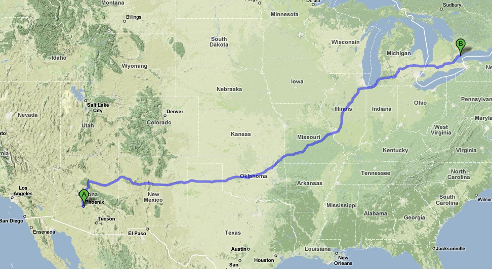
Route 2: Going on a diagonal across the Heartland.
Cities to pass through: Albuquerque NM, Oklahoma City OK, Tulsa OK, St. Louis MO, Gary IN, Detroit MI.
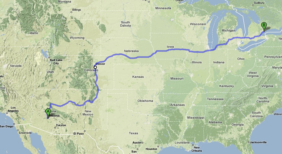
Route 3: Going north along the eastern edge of the Rocky Mountains and across the mid-west.
Cities to pass through: Albuquerque NM, Colorado Spring CO, Denver CO, Cheyenne WY, Omaha NE, Des Moines IO, Davenport IO/Moline IL, Gary IN, Detroit MI.
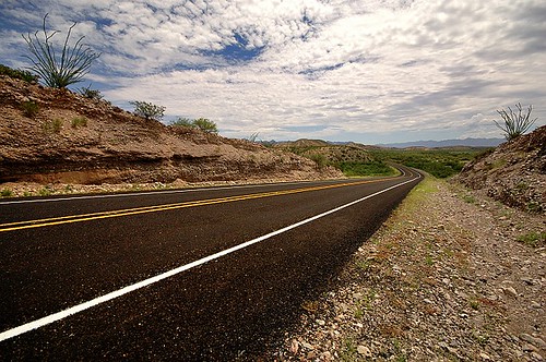
photo by Daniel James

43 comments
I vote for Route 2 if you’re taking Route 66.
Detroit. Must do.
I voted Route 1 as:
1. it’s the most southerly (and different) route from TOronto, ONtario;
2. less chance of snow (especially vs Route 3~I’d like you to arrive safely BACK in TOronto!;
3. Most states (9) and major cities to blog about!
I’ve always wanted to do one of those trips… where do you sign up? is there a website that hooks people up with possible drivers? Or do you know this couple?
Route 3 would probably be really scenic for the first jaunt, but I’m with Bob on choosing Route 1 because it’s probably the most different from what you’ve experienced before. Also, it would be cool for a music-lover to see Memphis and Nashville, plus I hear Kentucky is really pretty.
I chose route 3 just for Denver, although Colorado is worlds more interesting than Oklahoma.
“Additionally, RTD operates six light rail lines, the C,D,E,F,G,and H with a total of 34.9 miles (56 km) of track, serving 36 stations”
Also there is a huge pedestrian mall worth checking out, and I hear they have a pretty healthy playground scene with some of the largest urban games I have ever heard of.
The Tennessee stops on Route 1 do look pretty tempting, but only if you’re really into Elvis and religious symbolism. Skylines made of crosses!
But yeah, Colorado is awesome. Too bad they don’t live in California!
Hey Matt ~
I think I’d make my decision based on the roads themselves. Certain highways in the US are designated at ‘scenic.’ They’re the ones with the twisty mountain roads, great overlooks, waterfalls, bridges, roads chiseled out of rocky cliffs, or of historic importance.
Check out this online database and cross reference your maps!
http://www.byways.org/
ES
I selected route 3 because it keeps you out of the southern states and the troubles that a foreign car could cause in those parts. The south can be troublesome.
The northern route might be a problem since there have been serious snowfalls just days ago in Colorado. Otherwise, it’s the most varied route.
Several words of warning. Try to avoid Chicago and Gary. Chicago, because of the traffic and Gary because of the crime. Gary Indiana is one particularly grim city–and the home of Michael Jackson–which explains much.
If you do end up on Route 1 or 2, email me and I’ll give you some tips for Oklahoma City. I’ve spent quite a bit of time there, unfortunately, which is why I voted for Route 3. Still, there are a few key things to see in OKC. (Tulsa will be of more interest to you, with its art deco buildings.)
And you must of course stop in Chicago if you have not been there in the last five years. It’s Toronto on steroids…
Route 3, or you could use http://www.lightrailnow.org/images02/usa-lrt-map-cities-2007_nstprc.jpg as a reference.
Of course I can only comment on places, I’ve been, but I don’t think I would pick any of those three routes.
Personally, I’d want to go this way:
http://tinyurl.com/4cganv (2407 miles)
But some of the highlights there (Monument Valley, Canyonlands Ntl Park) are not on your list of priorities.
A southern route through Texas may take you to more interesting cities from a good and bad planning perspective: El Paso, Austin, San Antonio, Houston and New Orleans.
http://tinyurl.com/4gmudb (2791 miles)
But I haven’t been along the three routes you present, so I don’t know what you’d miss by not following them.
I chose those routes mainly becuz I have alimited amount of time to get back to Toronto (4.5 days). I need to travel about 800 km a day and want to make sure I get to spend a decent amount of time in a city (3-4 hours in two cities a day). But your first option is intriguing. And only 9 miles longer than Route 3.
This most likely doesn’t help at all but I love it down there. So here is my take.
How about route 4?
From Flagstaff (A great drive from Phoenix) meander north (stay east of 15) to 70 , passing through some of the most spectacular lanscape in the country ( Zion, Brice Canyon, Grand Canyon, Glen Canyon, Capitol Reef, Canyonlands, Moab, Arches…)
Hit 70, turn East to Denver. This will take slow you down a little but it’s well worth it. The images you burn in your mind will get you through the vast openess (equaly spectacular for a little while) between Denver and Chicago.
Otherwise, head south out of Pheonix to Tuscon west to 10, and north on 25 to Albuquerque.This will take you past the Cochise Stronghold, Tombstone, and through the town with the coolest name in America: Truth or Consequence NM.
Unless you find something intriguing to check out in Albuquerque, Tulsa, Little Rock, or Oklahoma don’t miss that part of the world.
Have fun
oops, just saw Spicer’s route. I second that one.
Anything you can do to avoid haveing to drive through Michigan/Illinois is worth it…you’ll want to slit your wrists out of boredom driving through those 2 states.
Route 1 – it’s the only one that avoids Michigan
route 3 will be excruciatingly boring. after denver, you will be in the most flat, mundane part of the US. There will be nothing interesting until Detroit. i totally disagree with what people are saying about the south. a foreign car will cause you no problems, and southern people are actually quite friendly, despite their reputation here in canada. they don’t call it southern hospitality for nothing.
regardless, you will be passing through detroit, michigan which is where i’m from and i can give you a few tips on things to see over there. if you are in detroit for any period during the day and want to see some art, the DIA (detroit institute of arts) was just renovated and is amazing, especially the room-sized diego rivera mural championing auto-workers (http://www.dia.org/). the hub of bike culture is backalley bikes, a DIY bike shop/coop downtown (http://backalleybikes.org/). Detroit is a city notably lacking in a decent transit system (thanks, auto industry), but the “people mover” is sort of cool and for a 1 dollar ticket will give you a nice little monorail tour of down town. if you are there on a friday and want drinks or soul food i would greatly reccomend checking out cafe d’mongo, which is an old speakeasy. The owner is an old couple larry mongo and his wife (i cannot remember her name for some reason, but she’s from toronto and if you introduce yourself she has alot of interesting things to say about the city before the high-rise boom). There is an out door market on the weekends called eastern market, and finally, try to check out scrummage university, an artist collective/diy showspace on the east side of town (www.scrummage.net).
if you want a real tour of detroit’s hidden spaces (tons of abandoned buildings and interesting waste), my friend joe stack is extremely knowledgeable and would take you on a great journey. his email address is stack.joe@gmail.com (just tell him dan epstein sent you)
detroit is a real interesting city – sorry if that was long winded.
oh and the one big advantage to route 2 is st louis. that city is absolutely lovely. if you are there, check out forest park. its like high park, but much more epic.
Despite the caption, routes 2 and 3 as pictured don’t go through Detroit. However it does pass through Sarnia and Flint – salutary tales of petro and auto-addiction, and Iowa’s corn fields / autoethanol factories.
Surprised no-one suggested a quick swing through Vegas to see the Monorail. (2560 miles / 4119 km via Utah, Denver, Chicago and Detroit)
I’d take route one. I’ve always found that southern cities really contrast their eastern/western/northern neighbours and I think you really should check it out.
If I remember correctly, the routing you have in Route 3 can be somewhat of a hassle as its full of 18-Wheelers and Road Trains which some can be intimidating for people who aren’t use to driving with them, and once you get into the Iowa/Ill. stretch, traffic can get be stand still during rush hour.
I did a variation on Route 2 coming back from the St. Louis area to Toronto last summer and I found that the trip through Illinois felt like it took forever. Not unattractive, but not much variation… lots of corn fields. You will enjoy if that’s your thing. Having said that, a stop in Chicago could offset the boredom of the trip through Illinois. Unfortunately I didn’t have much time to stop and had to settle for a drive-through (although it was in rush-hour traffic so the experience was longer!). St. Louis was interesting downtown as well, but it was surprisingly quiet — we were through there around 7 in the evening or so, and it seemed to conform to the stereotypical image of the downtown that closes up at 5. Makes you appreciate Toronto’s downtown life that may not operate 24 hours a day, but at least 18 to 20.
I believe Memphis and Little Rock both have new streetcar lines with replica equipment, if that’s your thing. Of course Denver and St. Louis have LRT systems, and I seem to recall that Chicago may have a modest amount of transit infrastructure or something…
why would you want to drive through Nebraska, and the rest of the hole in the united donut? take route 1, the south is much more interesting.
As with the first comment, I’d vouch for Route 2 for “you gotta do Route 66 at least once” reasons. But with a caveat if you really want to get hardcore into Route 66: a lot of that off-Interstate “ex-highway” stuff can be a devil on the suspension (or at least it was when I did the Illinois stretch in ’96). Not necessarily good if you’re doing the driveaway thing. (OTOH off-Interstate is the best means of boredom-aversion thru places like Illinois. And with a little Interstate-avoiding psychogeography-at-the-wheel sensibility, I don’t get bored too easily–even through cornfield flatness.)
As far as things-to-see goes from an enlightened-planning POV, because this is the USA we’re talking about, maybe aim for a few college towns. (In that sense, one problem with following Routes 2/3 too religiously is that while they avoid Detroit, they also avoid Ann Arbor.)
Oh, and re Nebraska: I’ve never been there, but remember that *that* particular routing carries Kerouac mythology. And I suspect that both Lincoln and Omaha might be urban sleepers worth examining, perhaps Yankee versions of what the likes of Regina and Saskatoon are to Canada…
Be sure to take photos of billboards.
I don’t have an opinion on the routes, but if you do go through St. Louis, you HAVE to visit the City Museum:
http://www.citymuseum.org/home.asp
Check out the photo tour. It would be so cool to have something like that on the TO waterfront.
Route #1: I drove through the south last September and it was well worth the gas money. Creepy little towns – the ones that horror movies are made from – fascinated me to no end and offered endless material for imagination-induced anxiety.
Saying that, driving through Nebraska does hold a similar attraction in a “Children of the Corn” sort of way.
I drove from Toronto to Vancouver twice… once the Canadian route and once down through the US. Last April I drove with two Aussies taking the southern route. If you don’t mind a short detour, I would definitely pop into Chicago… that is if you haven’t been there. That is one good solid day of driving from Toronto.
After that enjoy the long hours of driving through the rolling hills. I would refer to Bill Bryson’s “A Short History of Nearly Everything” for some sights to see in US, and then of course enjoy some scenic driving along the Rockies. Whatever you do, make sure you take your time, stop and check out things.
I drove a version of Route #2 several years ago. If you go this way, Missouri is beautiful, check out the caves.
I very highly recommend purchasing a Rand McNally USA road atlas before you leave, they highlight the scenic routes. A most fascinating document, I can stare at their various maps for hours.
I hope you might have someone else to share the driving? Pick up hitchhikers, I say. Or Craigslist a companion here and there to take over the wheel and let you really look at the landscape (or sleep on the highway so you have more time for towns).
As much as New Mexico would be amazing to explore, I have to say if you’re in Phoenix and you don’t go 4 hours north to the Grand Canyon, it’s a darn tooting shame. There won’t be many people in there as it’s not quite tourist season. The colour of the rocks and the depth of the canyons will make you feel like a spec of dust in the universe and at the same time one with the earth. It’s a powerful place. Plus between Phoenix and Flagstaff is a fascinating desert bowl. Just north of Flagstaff is the petrified forest. And Utah, Mount Zion and the Bryce Canyon: wow.
On the other hand, you’ve only got 5 days so maybe nature hikes will have to wait until you’re a retiree snowbird. In that case, I vote for a #1 more southerly route. Nebraska/Iowa is lovely heartland but fewer cities and more truckers. And Chicago deserves more than just 3-4 hours, so maybe it’s better to skip it altogether and take in Cincinati.
If city exploring is really what you’re after, you might want to time the driving parts after dark or in early morning hours so you can get more daylight in town.
Avoid roadside fast food if you can — nothing worse than being bung’ed up and driving. Lots of water and fresh fruit/veggies. Ahem. If you get stuck having to sleep on the road somewhere, church parking lots in small towns are good. Then you can hit up a public pool in a bigger city and use the facilities there.
I’m a woman so maybe this doesn’t apply, but when I take road trips alone I keep a crowbar under my seat, or that metal thingie you use to jack up the wheels. Watchit creeps!
Do you have an audio recorder? It might be good to just switch it on when you’re in places you like, so that you don’t have to take notes and you can point out stuff to yourself.
Drive defensively and watch for pedestrians…
I highly suggest heading north and definitely stopping at the Grand Canyon, you can’t be in arizona and not see it! After that drive through the Navajo region to southern Utah directly to the spectacular Bryce Canyon and than start heading east… or if no time for the scenic sites, head south to one of the coolest cities in America – Tuscon (they’ve created public garbage bins out of bicycle parts, and have a critical mass event every tuesday night), drink at the congress hotel, wake up, and head east towards new mexico and up to albuquerque and from there stick to route 2.
MapArt leaves Rand McNally in the dust.
What program is this? It’s something I’d really be interested in trying out.
Do route 2 and drive Route 66 where possible! It follows Interstate 40-44-55. From Chicago, drive via US 12-20 through Gary, Michigan City, and you’ve got two choices – either through St. Joseph/Benton Harbor or South Bend, but take the old Route 12 (not the current route 12) through Kalamazoo, Battle Creek, Marshall, Jackson and Ann Arbor and across Michigan Avenue (now Route 12) into Detroit.
St. Louis is a city I’d like to check out, but would need an excuse to go there, and you have that excuse. Take their LRT through East St. Louis and out through cornfields on the Illinois side, and check the downtown and Forest Park. If you end up through Flint, you’d hit the trilogy of infamous bombed-out US industrial cities – East St. Louis, Gary and Flint. (I’ve been to the latter two, Downtown Flint is something to see with all the landscaping amongst the boarded up store fronts.)
I did the old Route 12 between Detroit and Chicago (bypassing most of Interstate 94, but following it closely) two years ago, a really worthy drive. It is considered to be almost as important a historic road as 66. Interstate 94 stright through is as boring as hell.
Gary and Chicago are fine. It’s down, and there are bad areas, but to avoid the whole geographic area seems — out of touch.
I vote route 1; both for obvious deep-South reasons and because Kentucky is unbelievably beautiful. It’s a really cool landscape, and you can stop in Louisville (not far off I75 to Cincinnati) for a real taste of the old South.
I’m a fan of mountains (since they’re scarce in these parts) so I chose Route 3. I confess to not knowing much about the cities in the Plain states. My experience of driving across Prairie is marveling at the huge sky but otherwise wanting to get across it as quickly as possible.
And if you haven’t seen Chicago, it’s a must for someone in your position. Architecture, public space…it will make you weep for Toronto. Just do everything in your power to ensure you’re not arriving in or leaving the city during rush hour, because the traffic on the highways is mind-boggling. Don’t know what you’re doing for accommodation but you might try arriving late evening, bed down there, spend the morning exploring (If you feel like a tour, I recommend the Chicago Architectural Society’s Chicago River tour), and hit the road for Toronto (about 9 hours from Chicago) just after lunch.
Unrelated to route suggestions, but I would also recommend going to National Public Radio’s website, and printing out a list of their national affiliates, so you can mostly find them as you travel. When my wife and I travel through the States, having NPR to keep us company can make the trip go a lot faster.
Having seen the Las Vegas monorail recently, I can say it’s not worth taking a detour for.
In fact, there’s not much about Vegas worth taking a detour for.
Driving through Detroit is something worth doing. Grand River Avenue starting from Telegraph is perhaps the bleakest of all the major radial routes, and you get a nice angled view of the skyline. Michigan Avenue and Woodward are also interesting, and nothing’s starker than driving along Jefferson and crossing the city line into the Grosse Pointes.
But if you actually want to see Detroit, ride the Peoplemover (same trains as the SRT!), check out the DIA and the architecture, it’s better to make it a weekend trip and check out Windsor as well.
Route 3 for the view of the Rockies…but take take I55 from Gary to St.Louis and I70 from St.Louis through Kansas City to Colorado Springs…there is no point is missing out on Kansas City’s BBQ delights…this way you still get the mountains and great views from the prairies…
enjoy the ride
Matt, I actually had driven similar routes in the past (family in Colorado).
You’ll be bored as hell in Iowa and Nebraska where it’s plain and flat but Rockies will be your reward IF you change Route 3 as follows: in Denver do not go south but take I-70 West through the montains, this is one spectacular drive! You will emerge on the other side of the Rockies in Utah where you veer South, and go through incredible landscapes on yuor way to Arizona.
It may be longer but take my word for it, it’s must see.
I drove much of route 2 along Route 66 five years ago. Of the routes you list, I suspect this might take the longest given the number of distractions along the way (except for the long, long stretches through Illinois an earlier poster mentioned)
* US 12 (Michigan Ave) from Detroit to Coldwater is a decent diversion through Michigan, especially when you pass the 1950s-era tourist traps in the Irish Hills. Once you hit I-69 in Coldwater, you can pick up some time by heading south to the Indiana Toll Road (I-80/90) and taking that to Chicagoland.
* If you take the old stretches of 66 through Missouri, watch out for sketchy speed traps in small towns, especially around Bourbon(claimed the speed limit was lowered the week before, even though you were going the posted speed). I suspect this is why CAA suggested I detour through Arkansas and hook back up with 66 in Oklahoma…
* If time permits, Santa Fe is a great sidetrip from the main route (Route 66 passed through in its early years), recommended for its archtitecture and the chance to see a coyote walking calmly along a freeway exit.
Great Olmsted parks in Louisville.
Detroit – a planning paradox.
Remember that old Route 66 routings tend to be indicated by special markers–following them through Illinois is a great monotony-buster.
And, all in all, I wish people wouldn’t make these pat assumptions about getting “bored as hell” in the flat Midwest. If anything, I’d associate boredom-as-hell less with geography than with highway type, i.e. an Interstate through the Rockies can actually be more tedious than an old US highway through Nebraska…
In a similar “Midwest monotony-buster” spirit to the recommendations of Route 66, or Michigan’s Old Route 12 via Kalamazoo et al–if you’re doing Route 1 and have a good sense of direction + reference points, it might be fun to trace the old Dixie Highway that parallels/preceded I-75 through Ohio. (I did it to Cincinnati ‘way back in 1991.)