

After my walk around Flemingdon Park (and being questioned by the police for taking photos), which I described in yesterday’s post, I decided to walk over to neighbouring Thorncliffe Park. It is a similar, also somewhat isolated towers-in-the-park development, with a diverse population of about 15,000, and the local residents said there is a good sense of community between the two “Parks”.
The two communities are physically close — it’s hardly more than a 5-minute walk — but they are separated by an unpleasant, though safe, bridge over the Don Valley. The pedestrian walkway is protected from the very fast traffic by a barrier, but the walkway is very narrow, with traffic rushing by on one side and a beautiful view but vertiginous drop on the other.

On a rainy day, I discovered, there was a further obstacle at the entrance to the bridge’s walkway — a puddle in the road so deep that the splash from cars speeding by carried right over the barrier and would soak a pedestrian from head to toe. I had to time my passage carefully to make sure there was no traffic coming behind me when I passed this point.

A local community activist told me that cycling across the bridge is a nightmare, which I can well imagine — the lanes are narrow, traffic fast, and there are lots of buses.
It seems to me that this is a location that really needs a separate pedestrian/cycling bridge. It’s the connection between two large and closely intertwined communities — Thorncliffe Park students cross to get to the high school, while many Flemingdon Park residents shop in the East York Town Centre mall in Thorncliffe Park. The bridge is on the proposed route of the Don Mills rapid light rail transit line, so it may be that the bridge will be upgraded or replaced at some point. When that happens, there needs to be a wide, dedicated bridge for cyclists and pedestrians that is separate from the roadway.
As well, it seemed logical to me that there should be a pathway between the two communities going down into the valley, intersecting with the Don Valley trail there, crossing the Don on a little bridge, and then up again into Thorncliffe. It could be done quickly and wouldn’t cost all that much to build, and would make a pleasant connection between the two communities and with the ravine between them. It could work particularly well as a route across the ravine to the high and middle schools from Thorncliffe Park, at least in the fall and spring. I didn’t check, but I expect students have already created informal paths into the valley over the years.
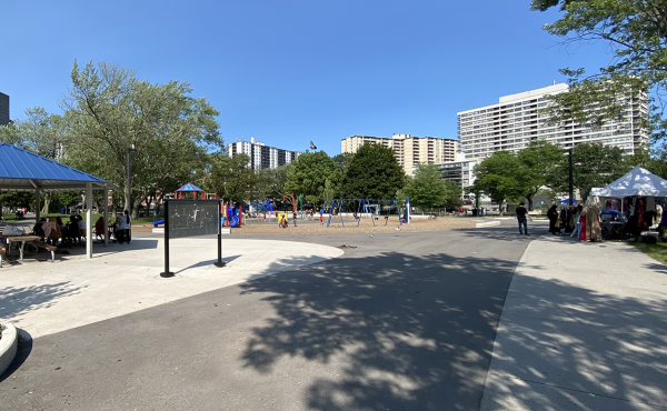
As I noted earlier, Thorncliffe Park is built in a “U” shape with a series of tall and mid-sized towers wrapping around a series of amenities in the middle – the East York Town Centre mall, an elementary school, and a park. Connections can be made both along the “U” of Thorncliffe Park Drive, and through a pair of pedestrian pathways crossing each other in the middle of the “U”. The elementary school, located right behind the mall, has 1,900 students, making it the largest elementary school in North America. It was extensively rebuilt and expanded recently, but it already needs additional portable classrooms as well. Residents noted that its constant need for expansion was eating into the limited available recreational space for the school.

The new addition is on the right, and you can see portables on the left.
Some of the tall slab buildings are unfriendly to street, with the walking entrance set a long way from the street and not facing it. Others are much more street-friendly. The one below is particularly good: it faces the street; is close to the street, without a large setback; and the entrance is oriented towards the street with a specifically pedestrian entranceway up the steps. Its main drawback would be the huge shadow it casts over the street because of its orientation on the south-east side of the community (visible in the Google map I link to above, although not an issue on the rainy day I was there).

Walking around the community gave the impression of much better interconnection between residential buildings and facilities than in Flemingdon Park. The north-south pathway through centre of the community went directly to an entrance to the mall, creating a pleasant pedestrian link. Note the way that where the path crosses the mall driveway, design elements have been used to give pedestrian priority — the pedestrian pathway is made distinctive and dominant with bricks, and raised so that the pedestrian path is at an even grade, but cars face a bump.


The pedestrian access to the mall from Thorncliffe Park Drive (the “U” street) on the east side, however, was not very friendly, with no pedestrian paths across a wide parking lot, making the mall less pleasantly accessible for people living in the tall buildings on that side of the community.
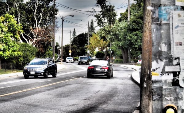
One last thing I noted before catching the bus was an example of a direct pedestrian path. The well-used track visible across the median goes straight as an arrow from a mall entrance to the transit station across the street — even though there’s a signalized intersection less than 20 meters away to the east (to the right in this picture). It’s hard to stop pedestrians taking the most direct route.

Although Thorncliffe Park is reasonably coherent in terms of internal walking, it remains desperately isolated from the rest of the city in terms of walking or cycling access beyond the community. There is lots of transit — several frequent routes to various destinations. But if you want to get somewhere yourself without a vehicle, the routes are are pretty unpleasant, especially long, barren and busy Leaside Bridge (although last night a friend told me it isn’t too bad for cycling). Although lots of transit ensures the community is not really isolated, the difficulty of getting out of it by yourself made it feel psychologically isolated to me. The building of the Don Mills rapid transit route may provide an opportunity to also establish much more pleasant cycling and walking infrastructure along the Leaside Bridge south towards the Danforth, westwards along Millwood towards Leaside itself, and into and across the Don Valley.
8 comments
I rode across the Overlea bridge every day for eight months last year; it’s quite unpleasant. I took the lane most of the time and didn’t encounter any kind of road rage or unpleasantness from drivers when I did. Doing the same thing further west along Overlea was a whole other matter, though. Most other cyclists I saw on the bridge rode right up next to the concrete barrier or on the narrow sidewalk. Either option seems far more dangerous to me than simply taking the lane and ignoring the horns (if any) for 30 seconds.
My office is located just north-east of the Eglinton East-Don Mills intersection and I take the 100 Flemingdon Park bus from Broadview Station to work every day. I’ve decided to try cycling to work on Fridays this summer, and from the bus in the mornings I have been plotting my route.
While there is a bike lane on Millwood Road, which crosses the Don Valley, I routinely see cyclists hanging on for dear life in the mornings as caravans of buses and other large vehicles blow by in the right-hand lane. And once on Overlea and, later, Don Mills, it’s a full-on tango with several lanes of rush-hour traffic.
One of my colleagues cycles in from Cabbagetown, and he’s suggested I take the Don Recreation Trail from Dundas all the way up to the Science Centre, where I can shoulder my bike and climb a set of stairs up to the intersection of Eglinton and Don Mills, thereby minimizing time spent pedalling the traffic-clogged main thoroughfares.
This, of course, is a lovely scenic route, but that doesn’t change Thorncliffe and Flemingdon Parks’ desperate need for some cycling infrastructure. While I think I’ll fare alright having to carry my bike up out of the valley, I wonder if that factor would deter others who would otherwise consider biking to work in this area (the parking lots at Celestica and Forrester’s are absolutely jammed).
A great piece, Dylan — likewise the Flemingdon Park entry. Fascinating to have your perspective on these two neighbourhoods that I travel in every week day.
My partner and I live in Thorncliffe Park, and after four years it’s still our favourite Toronto neighbourhood. We feel very safe here, people are extremely friendly, and because the area was made deliberately to cater to pedestrians, we can always wait out TTC strikes (though we don’t own a car) because we can walk to almost anything we need. (Grocery store, thrift store, drug store, community centre and library [under construction currently, but will re-open next year], department store, etc.) And people in this area *do* walk, quite a bit. I certainly don’t feel isolated, and the 25, 81, and 100 buses pass every five to ten minutes when I am ready to head downtown.
My partner cycles to work every day. Because his place of work varies, he’s left our neighbourhood for places all over the GTA, and after struggling through the horrors of suburbia he’s always grateful to return to Thorncliffe Park. He can get to the Big Carrot health food store at Chester by riding almost entirely through the park, which is a lovely ride, and makes it possible for our child to get the thrill of riding to another neighbourhood without having to brave the roads.
I adore Thorncliffe. I’d recommend it to anybody.
Alicia> What route do you take to get to the big carrot that is all park? Is the don valley? I never use the valley for commuting (but do for fun) because getting up and out of it is such an effort.
Thorncliffe Park has access to the ravine by way of the E.T. Seton park. Take that down to Riverdale Park and go across Hogarth. I generally prefer to go the street (Overlea -> Millwood -> Pape -> Danforth) as it is a bit quicker but if you’re tired of dealing with traffic it is a nice alternative. But yes, it is a bit of a pain to get up and out.
Cycling Don Mills wasn’t as bad as I thought it would be. Rush hour’s a bit better, ironically, because of the fact that most people avoid the right lane (3+ passengers, taxis, buses only). Overlea and Don Mills intersection can be tricky but isn’t as bad as it looks IMO.
I bike to work from downtown to Don Mills and Eglinton everyday. The Overlea bridge to Don Mills can be a little hectic with buses and schoolkids. Ironically, this traffic actually makes it easier to turn left onto Don Mills because there is usually a car turning that blocks off traffic just enough for me to get into the left turn lane. At any rate, the ride isn’t so bad because of the diamond lanes.
Please can somebody help me out. I am new to this place. Deciding on the place to stay here. Will be staying with kids. Is Thorncliffe the right place. Are there many muslims too as I too belong to this community and is Halal food easily available. Which is the best place and safest place in Thorncliffe par.
Hi friends, Am planning to settle in the said area. Can somebody let me know if there is a good school around the area for grade 8 and up. Also which is the nearest subway to reach the university of toronto. Can somebody suggest some real estate agents to help search my condo. What would be the rent for a single bedroom condo?
many thanks in advance..
regards
Munir