
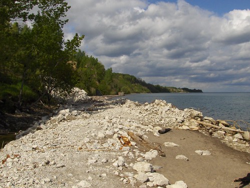
Sunday turned nice and computers were turned off and left at home for a trip to (what feels like) the most remote part of Toronto: the beach along the Scarborough Bluffs. We started at the Guild Inn and made our way down an old abandoned road to the lake. You can trace our route on this Gmaps Pedometer map (a wonderful Google maps application where you can plot out a route and see how long it is). The road was likely once open to cars but today is only used by pedestrians, cyclists and service vehicles that construct and maintain the elaborate breakwall. We walked nearly 3 kilometers down the beach, and discovered some public works ruins — a rare find in Toronto — that felt a bit like the end of Planet of the Apes when Charlton Heston finds the head of the Statue of Liberty on a beach, under some sandy cliffs.
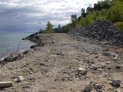
Quite a bit of work is going on along a portion of the beach, with chunks of concrete and rebar laying around, waiting — we assumed — to be turned into more of the neat and tidy breakwall that ran until this point.
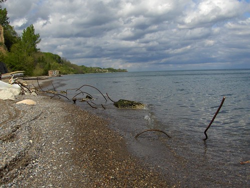
Toronto’s most dangerous beach with rebar sticking out of the water, or worse, pointing upwards just under the surface.
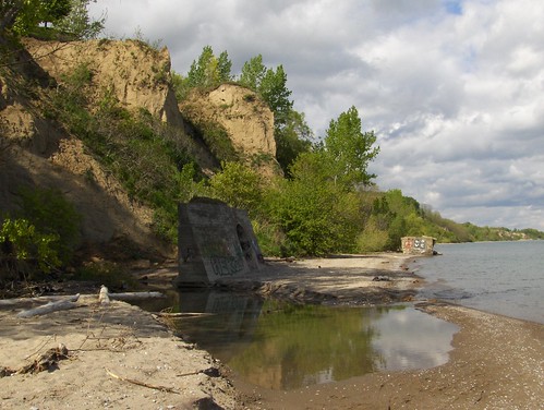
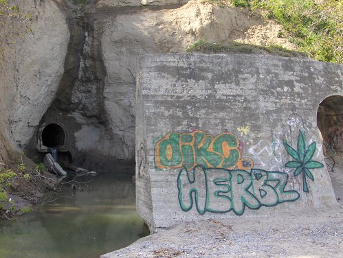
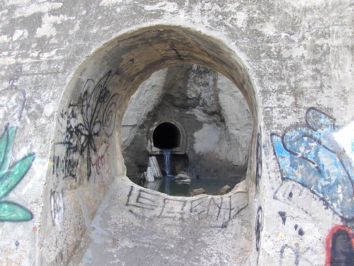
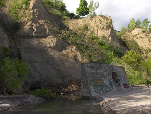
As we rounded the corner, we heard what sounded like a waterfall. We found one, but not the kind we imagined, though the water did look clear and did not foam. The Planet of the Apes hunk of concrete appears to have once been attached to the sewer coming out of the bluffs.
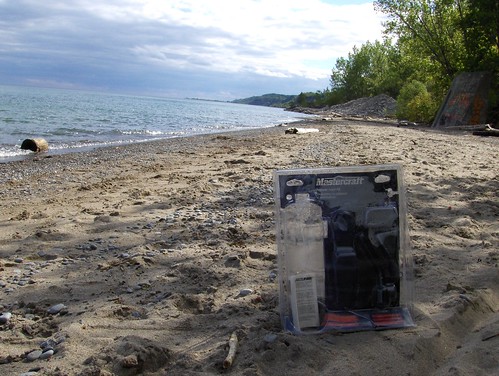
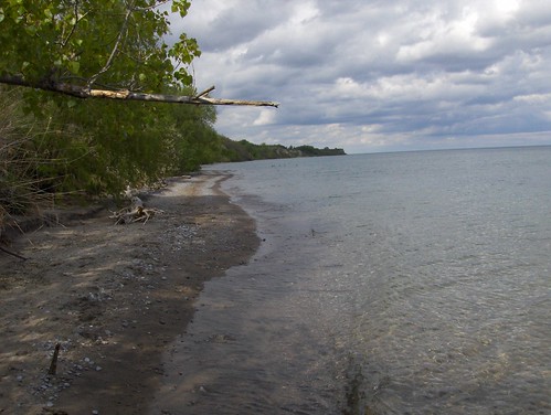
The beaches along here are not regularly cleaned, but they are remarkably debris-free. Some over-packaging from Canadian Tire was one of the larger chunks.
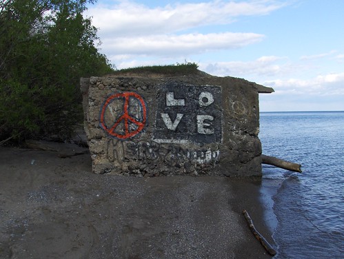
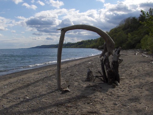
Another strange and mysterious chunk of concrete.
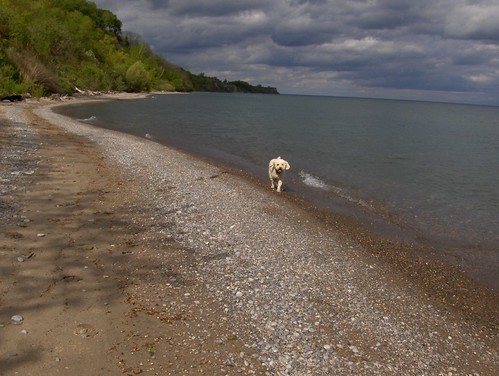
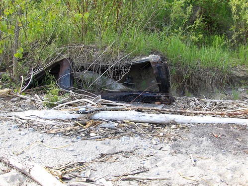
Above, the roof of an old car or truck lays half buried. Beyond is more empty beach. Surrounded by a metropolitan population of 4.5 million people, we passed just 7 of them on our 5km round-trip, even though we were just on the edge of the city. Had we continued, we could have made it to the mouth of Highland creek where the next access point to civilization and the real world is located.
13 comments
I’m guessing the concrete chunks were once at the face of the bluff and since stranded by erosion?
My brother used to live near here and I loved this walk. It really needs to be made more accessible with a graded path so that Toronto would have a unique and useful asset for joggers and bikers. Hopefully that breakwater wall will one day run out to Pickering.
You should start at Guild Inn and walk the other way next time–this walk takes you through the most beautiful scenery in Toronto. Leave the trail by way of Bellamy Ravine or (if you’re feeling adventurous) wade through the lake until you get to Bluffer’s Park. If you do the latter, you’ll get to see very interesting views of the water eroding the bluffs.
http://www.flickr.com/photos/gerrychu/568392881/in/set-72157594574467742/
http://www.flickr.com/photos/gerrychu/567959028/in/set-72157594574467742/
http://www.flickr.com/photos/gerrychu/568396729/in/set-72157594574467742/
gerry> indeed, heading west from the guild is one of the best bikerides in the city. at the base of the bellemy ravine .. ‘the doris mccarthy trail’ .. is ‘the passage’ artwork. wrote up in spacing a few issues ago. I have always wondered about making it to bluffers park via wading, but am always on bike. the challenge is to ride up the trails long incline…difficult after first riding to the guild from downtown. nice pics.
usky> perhaps necessary for erosion , but I hope the break wall isn’t built as it becomes sort of boring, after a while, compared to kilometers of ‘virgin’ beach. these are lovely beaches.
It is a very nice area for a bike ride, and the cliffs are about 100m climb for great a cardio workout.
The area has had a hundred years of garbage dumped there. Before the new linear park was built (a few miles farther down to the east) I counted 4 or 5 vehicles embedded in the beach. From the tires you could tell one truck was probably from the 1940s. It is common to find all kinds of unusual garbage (e.g. religious items). For some reason we see coconuts all the time which is odd as there aren’t a lot of palm trees around Lake Ontario.
The Guild Inn itself is a disgrace and a sad testament to government mismanagement. Have they bulldozed the hotel extension yet?
The Highland Creek system just north of the Guild is also outstanding. Scarborough is one of the safest and most beautiful areas of the city, but don’t tell anyone, it will spoil our bad-ass image.
I forgot to mention the time I found a heavy-duty safe on the beach. It had been thrown off the cliff. Reported to the authorities as I figured some sort of crime had to be involved. It was still there the next year. It has probably sunken into the sand by now.
Wow… this just brought me back to the 90’s and my highschool years. I went to Sir Wilfrid Laurier (beside the Guild Inn) and when we used to skip class we would do this walk. And the many night time bluff parties there were a blast too. Great hidden area of the city for sure.
Thanks for the link to Gmaps Pedometer; a great tool. By the way, speaking of Google maps, does anyone know how to contact them regarding errors on their maps? They’ve recently added the letter M to mark Toronto subway stations but many are way off the mark showing stations at Keele and Wilson, Keele and Sheppard and Dufferin and Eglinton among others.
^Maybe Google is sponsoring new subway lines with their billions?
I am 58 yrs old and grew up living on the bluffs at 17 Midland Ave. I know the bluffs almost every inch of them having climbed them and played on them almost every day of our lives. Please write and If i can answer any questions i will try to answer them. That other big chunck og concrete is down behhind not far from the park area and what we called the seminary flats up above
. My Dad said when he was in the airforce it was an observation station for practice bombing over the lake during the war, and by the way a practice flash bomb was dug up in our back yard by my stepmom in the early 50’s look it up in the papers.
When I was young the beach was much cleaner and a lot wider and there were more peaks. We were able to walk all the way to Pickering and take the bus home on a weekend camping on the way it was fun days
.We still visit often due to marrying the girl up the street I visit my motherinlaw. My parents are gone now. If you go to Warden Subway station there is a large pic on the wall showing what the bluffs looked like when i was a teen my house is in the pic it was taken of the bottom of Midland Ave from the air.
Hi:
I loved your photographs and they inspired me to experience the same walk. Could you tell me the name of the old road south of Kingston from which you started. The only access information I have is going south on Brimley to Bluffers Park but that is too tame.
Thanks.
Helen.
The access road is found just to the east of the Guild Inn (you can actually find a path from the Guild Inn grounds too, that connects to the road down). For this walk we went left/east. Heading right is good too, and you will end up finding a path back up to Bellamy road/Kingston Rd.
A few kms to the west is another abandoned road that takes you down to the base of the Bluffs. This is off Glen Everest Road, immediately east of Rosetta McClain Gardens. After following the abandoned road to the lake shore, you can walk about 2 kms east (you can go west too, but I haven’t explored that direction) until you reach an impassable section just before Bluffers Park. This is about the most secluded spot in Toronto that I’ve seen. Fascinating place; made me a bit nervous to be there by myself.
The path is right next to Wynnview Crt. It doesn’t start right at the curb so it’s easy to miss, and there is a barricade so you can’t drive through it.
I just went down there for the first time last week but didn’t have enough time to explore it as much as I wanted to.