

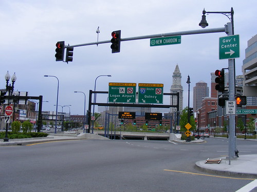
A post on the big dig for Spacing could not have come at a more opportune time with the recent announcement of a concrete plan to tear down part of the Gardiner Expressway. One of the pleasures of driving to Boston was the chance to drive Interstate 93, which passes through central Boston in a new underground tunnel known as the Big Dig.
The Big Dig project involved much more than the burying of the elevated Central Artery, it also involved the construction of a second tunnel under Boston Harbor to Logan Airport (known as the Ted Williams Tunnel), a new bus rapid transit line, the rerouting of the light rail MBTA Green Line, and a new cable-stayed bridge over the Charles River. The entire project cost $14.6 billion US.
Driving through the new underground expressway was somewhat of a let-down, making me wonder if “that was it?” It’s nothing all that special really, not much different than any other highway tunnel, except with on-ramps. I was more thrilled to drive the Autoroute Ville-Marie in Montreal last year, though getting from the south of Boston to Cambridge via Interstate 93 had me exit the tunnel near the northern end and navigate a confusing maze of ramps before getting onto the interesting Longfellow Bridge and across the river.
There are several differences between the old Central Artery that the Big Dig replaced, and the Gardiner Expressway here. Interstate 93 is a major through route connecting Cape Cod, Rhode Island and the southern suburbs to downtown Boston and north through to the northern suburbs and New Hampshire. Logan Airport is also right across the harbor from central Boston and therefore it is a major traffic linchpin. Though the Gardiner was intended to continue east by way of the cancelled Scarborough Expressway, it never had the same function as a through route.
Secondly, during the construction of the Central Artery, a huge gash separated the historic downtown in two. When the elevated portion of the Gardiner was built, just about all of Toronto’s downtown was north of the railway lands, and did not have the same effect until the Harbourfront began to be redeveloped, starting in the 1970s.
Finally, and most importantly, while there were plans to bury the Gardiner in whole or in part through the 1980s and 1990s, the current plan centres around bringing the traffic down to street level. Above Interstate 93, a large park still leaves a scar through the city, and there are still many on-ramps and off-ramps leading into and out of the tunnels.
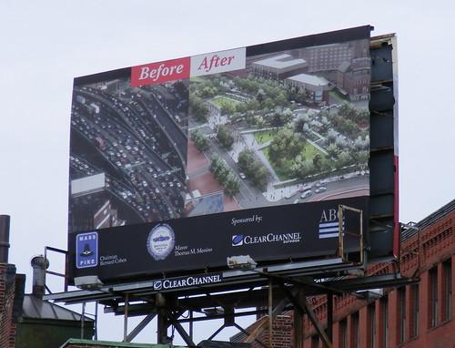
The current plan for the Gardiner, of building a 8-lane urban boulevard between Jarvis and the Don Valley Parkway, is likely the best compromise, for now, for motorists versus pedestrians, cyclists and local residents, though the biggest issue in my opinion is the maze of ramps at York/Bay/Yonge. Even burying the Gardiner, as once planned, would not be a perfect solution either. While the Big Dig at the surface is nicely landscaped with parks and walkways, it remains a bit of a barrier, with long traffic light cycles to cross the surface streets, and the urban fabric destroyed with the construction of the Central Artery has yet to be filled in. Boston’s solution is a big improvement, but is still not ideal.

21 comments
How is an “8-lane urban boulevard” good?
It would be better to have an elevated highway.
At least that is easier to walk under.
The one problem I have with the Big Dig, speaking as someone who is not from Boston, is that it is *very* un-GPS friendly. When your navigation system blinks out the moment you get in the tunnel and takes with it the information on where you’re supposed to get out of the tunnel, that’s very disconcerting.
It was also common to be driving along the surface streets and suddenly have the GPS think you were on the highway underneath you and start giving crazy directions.
Hopefully GPSs improvements will make that a moot point, but at the moment, the Big Dig is a serious pain in the ass for lost tourists trying to get around Boston.
I’m with hey. The Gardiner is the biggest non-problem in Toronto today.
One bizarre component of the Big Dig is the cable-stayed bridge that carries the traffic over the river between downtown Boston and Cambridge. They chose the right designer but pretty much blew the design by overloading the bridge with traffic lanes and choosing a type that was not really proportionally right for this span. The extra lanes on the bridge make it asymmetrical and the result is stocky:
Main span: 227.1 m
Width of deck: 56 m (8 lanes + 2 more on one side)
Span-to-width ratio: 4:1
This is simply not very elegant. Other modern interstate cable-stay bridges have ratios of 8:1 (Fred Hartman), 12:1 (Sunshine Skyway, Ravenel Bridge, Veterans-Texas), 13:1 (US Grant), etc. Even the recent Veteran’s Glass City in Ohio is 5:1.
Making it worse, there is another bridge next to it that is essentially a giant off-ramp, ruining the view of the bridge from that side and mocking its function — why do you need a cable-stay bridge if the same span can be handled with a boring concrete off-ramp? Bizarre.
http://maps.google.ca/maps?f=q&hl=en&geocode=&q=back+bay+boston&ie=UTF8&t=h&layer=c&cbll=42.349823,-71.085222&panoid=XNrAp1am10-zL63hcRfscA&cbp=1,40.6575271863955,,0,2.4852642221449703&ll=42.358576,-71.077294&spn=0.024989,0.057335&z=15
Dear Hay and Iqbal W.
Since we’re talking about Boston (which has a lot Toronto can learn from) Please take a look a the Commonwealth ave.
Although not quite 8 lanes (I don’t think?), its an excellent example of what we need more of in this city.
Hopefully the above link works and you can take a walking tour of the avenue to understand why Toronto needs Boulevards. They can be incredible if done properly, and we need to look for outside examples, because University Avenue is not cutting it.
P.S. I was recently in Boston in April, and the greenspace created by the big dig is really something. I found it calmed traffic and dulled the noise by a large street because of the greenspace in the middle. And, in parts of it, because of its sunken nature (two steps down to the grass), you could lie down and barely hear traffic or anything! (I fell asleep 🙂
@Jacquilynne
a few of these in the tunnel (assuming the maps were updated by the vendor to the device) would likely do the trick.
http://www.ofcom.org.uk/radiocomms/ifi/enforcement/gpsrepeaters/
I personally find the post-Big Dig corridor to be completely and utterly underwhelming. Aside from a few blandly pleasant lawns and plazas that don’t seem to be used as much as they should, it remains a huge gash separating downtown Boston from the waterfront. It isn’t as noisy and unpleasant as the old Central Artery but it’s still not a very welcoming place.
I also think the Big Dig was a complete failure when it came to repairing some of the damage done by the original highway’s construction. The Haymarket used to be a real street market hemmed in by buildings on both side — why wasn’t a market hall or some new buildings built as part of the Big Dig? It could have added so much to the market. Instead it’s been left pretty much the same as it was when the highway still existed.
Thanks for the link, Tyler, but I remain unmoved. I think Christopher’s description of the Big Dig corridor is the most likely outcome for the boulevard that replaces the Gardiner: bland, useless and unwelcoming.
Your nap aside, who wants to hang out on a glorified traffic median?
If the problem is our connection to the Lake, why not start with Lake itself? The real civic shame of Toronto is the fact that you can’t swim in the Lake. And yet, here we are hell-bent to spend hundreds of millions improving our connection to the sewer run-off, fecal matter and E.Coli! Instead of tearing down the Gardiner, let’s take a couple million to improve the underside (starting with a skate park), and spend the rest on the sewers and storm drains that send our shit into the water we’re so desperate to enjoy.
For the massive price, the Big Dig corridor should be something that’s unquestionably spectacular. I agree with others who rate it as mediocre.
Tyler’s example of Commonwealth Avenue is interesting: yes, it’s a nice, tree-lined walk, but the bulk of activity in the neighbourhood occurs on Newberry Street, two blocks away. Commonwealth may just be too wide and divided for vibrant street life.
Iqbal, one of the real civic shames of Toronto is that everyone assumes the lake is more polluted than it really is. Centre Island, Cherry, Gibraltar Point, Hanlan’s, Ward’s, and Woodbine beaches all have Blue Flag certification; that’s an international standard that requires beaches to meet EU clean water standards (and sets a maximum number of days they can be posted “no swimming” due to pollution).
If Toronto was to spend bajillions on a “big dig” it damn well better be for a new downtown east/west subway or to bury the rail line, NOT to bury a freeway.
Said “bland, useless and unwelcoming” is arguably already in effect w/whatever replaced the Gardiner E of the DVP. That said, I’d presume that any move on the Gardiner’s downtown stretch would be (or already is being) accompanied by urban development/renewal/intensification that’d mitigate a whole lot of that.
Pretending this kind of corridor off as a “greensward” (as seems to be the case in Boston, maybe with a touch of anti-urban pathology) is denying the issue.
Spending umpteen hundreds of millions for private mobile furnaces is rather foolish, given climate change and peak oil. Effective transit that combines a solid eg. fast east-west route aligned with existing and real transport demand makes sense, and proper transit would mean a larger U using the Weston Rail corridor and the Don Valley yet still linking to the existing system and destinations. I think mostly on the surface on Front St. is wiser than most other places for this.
Interesting road trip report. I’m with the two “non-issue” writers. Love the skate-park idea (even if we wouldn’t be the first off the mark on that one).
Liked Christopher’s comment about Boston’s lost opportunity to regain a “market street” and Adam’s comment on intensification. Definitely having a mix of “boulevards” AND cozier urban spaces (= “outdoor rooms”) is something we seem to need to balance more in our current urban development.
Also, we shouldn’t make it too over-designed and sterile. Leave room for something like randomness and chaos – keep it a bit gritty, like maybe making room for street art areas.
I lived in Boston about a decade ago and to me the elevated Central Artery was an atrocity – it truly divided the neighborhoods, was noisy and packed with traffic all day round. As the Big Dig progressed, one could see that a much better solution was emerging (all the pains, time and cost overruns aside).
I agree that the end surface result is a bit underwhelming – the green spaces are still barren – but let’s give it a little bit of time, please. Boston is much better off becuase of the Big Dig and I think the space utilization will continue to improve.
Comparisons with Gardiner are only partially relevant. To me, Gardiner is a big obstacle and it’s getting close to capacity. That’s the similarity. However, in terms of technological complexity, sinking Gardiner underground would only superficially mimic Boston’s project – it will be nowhere near the difficulties encountered there. Which means: Do it. Now!
ok….so we’re going to replace a perfectly good structure with an eight lane highway….sounds perfectly “Toronto” to me. Notwithstanding that it needs maintenance (but nothing else we build does right?) that has been deferred for YEARS (maybe the millions Council spent on MFP could have been spent on a major piece of city infrastructure, non?). Beautiful, now I can risk my life getting to the lake….notwithstanding you really can’t get to it once you’re there, but it’s a romantic thought isn’t it.
So,,we’re going to remove the Gardiner….hmmmmm….what to do about those pesky elevated trains…..hmmmmm….let’s get rid of those elevated bits too – God knows that Union Station was built to also handle “at grade†train service too (in case you didn’t know, the trains were elevated back in the 1920’s because people were getting KILLED).
There ya go! 12 or 13 train tracks THAT YOU CAN’T SIGNALIZE and 8 lanes of auto traffic to dodge.
You people are completely on drugs.
Build a damn east-west subway already.
One of Toronto’s (and Canada’s) biggest problems is not making people pay for their location choices. I’m all for free health care and public services, but when it comes to PRIVATE roads or lands, surbanites should be paying for the environmental and architectural scares left on the city.
Put tolls on the gardiner, stop making me pay for it, and I’d be a lot happier. I agree that it’s ugly… but the city could use a bit more cash, and it should come from the people who are only hindering our city by driving through it.
I dont see how something like Commonwealth Ave. could possibly handle the combined traffic we are talking about. I would also like to add a few points that get easily lost.
Downtown people drive too. I sometimes use the Lakeshore to head over to the east end.
Downtown drivers also use Go and TTC. I have both near my house and in fact walking is my preferred mode.
I like to cycle but I don’t want to cycle to work, it is not as practical for me as TTC and sometimes driving.
My point is Sean that its all about MIX as opposed to “motorists versus pedestrians, cyclists and local residents,” a resident doesn’t have to be one or the other and our goal is to help people have a healthy mix. Absolutes, like no bike lanes, or banning cars, just is not going to happen. I think we all need to view all citizens as more complicated than just one designation and therefore need. (Hamish is a healthy exception and his lifestyle would not work for most but he has made his mix choice.)
Scott:
That’s my error. When I meant “motorists” I was thinking of the ones who commute from elsewhere by car and use the Gardiner for that purpose, as opposed to local residents who might also be motorists and who would directly benefit from a Gardiner take-down. Perhaps I should have said “motor commuters” – the Jarvis to Lakeshore urban boulevard could be one way to accomodate all forms of transport, be it car, bike, walking (and transit, especially with a Downtown Relief subway!).
I’m certainly one to advocate a mix as well, and one pet peeve of mine are the all-too-self-righteous anti-car types – I hope I never came across that way.
The Big Dig isn’t a white elephant but it certainly delivers little bang for the buck. I wonder if simply building the Ted Williams tunnel + another tunnel under the Mystic river and rerouting the entire I-93 via Logan airport would have achieved the same traffic results for far less money.
The biggest scam of the Big Dig is that transit improvements essentially involved realigning the Green line and the construction of the Silver Line – a consolation prize if there ever was one. One of the funniest things about transportation planning in Boston is that the city has pretty much the same rapid transit infrastructure that it did in 1920 – except that entire lines have been buried, moved or rebuilt – often at great expense!
I used to live in Boston. I find many parts of the new greenway to be underwhelming, but hopefully with time – maturing vegetation, new buildings, more green spaces, &c. – the greenway will mature into one of Boston’s must see and highly used public spaces.
I wrote about the Big Dig here: http://localecology.org/localecologist/2007_07_01_archive.html
I lived in Boston for six years and left just before the Central Artery was torn down.
The interesting-looking bridge the writer refers to is probably the Zakim Bridge, named after civil-rights activist Leonard Zakim. Cool-looking structure. The Longfellow Bridge is an older, drab structure that links East Cambridge (at the eastern end of the MIT campus) to Boston (just north of Mass General Hospital). Main Street (Cambridge) and the MBTA Red Line run on it.
Looking forward to visiting Boston again sometime soon to see what they’ve done with the space.