
Last month, I had the opportunity to visit Bogotá. As late as a year ago, I had never expected to visit Colombia, as it was not on my radar as an interesting – or safe – place to enjoy some time away. But a family wedding brought me here, and many of my preconceptions went out the window. The people are friendly, the countryside beautiful, and the security much improved. (It was especially nice to be so far south at a time when even the US south was suffering from a lingering cold snap.)
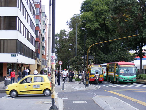
Bogotá, the nation’s capital and largest city (with a population of about 8 million), is also one of the world’s highest cities, with an elevation of 2600 metres. The city is spread out on a north-south axis, As Bogotá has grown, so has its transportation headaches. Like most Latin American cities (even including those with heavy-rail metro systems), the principal mode of public transit are private minibuses, which travel along all the major roads with the route posted on the windshield, merely a long list of neighbourhoods and landmarks the unscheduled service stops at.
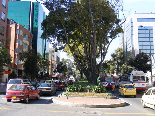
Huge fleets of minibuses, stopping anywhere they are flagged down, aren’t exactly the most efficient mode of transport, though it can be convenient (and cheap) for passengers. Combine those buses (of varying age, upkeep and tailpipe emissions), with trucks, motorbikes, private cars and other street traffic, in a city surrounded by mountains, and you have a recipe for a smoggy, congested, mess. So the city, under the leadership of bold, clever (and sometimes near-dictatorial) city officials began to address it with a three-pronged attack: buses, bikes, and bans.
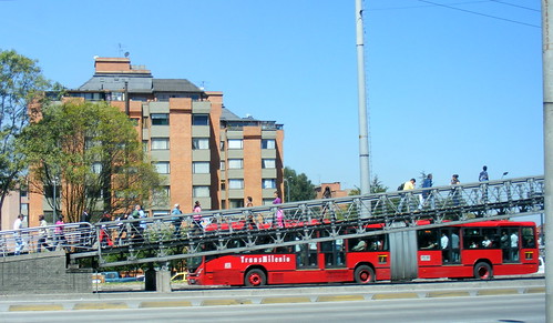
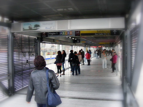
During the last decade, Bogotá took the lead of Curitba, Brasil, and began rolling out an advanced bus rapid transit system, called TransMilenio. TransMilenio solidified the Latin American tradition of high-concept BRT systems (which has been replicated in Mexico City to augment its already expansive Metro system) with a complex web of routes operating in exclusive lanes and serving fare-paid platforms in simple, modular, stations.
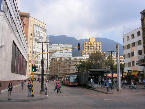 TransMilenio proved to be more complex than I expected. There are dozens of routes (even though there are perhaps only three major corridors). Each route number starts with a letter which corresponds to one of eight zones in which the bus terminates, while the one or two digit number corresponds with the service pattern (every day, weekday peak only, express, line-haul, short-turn service, etc.). The stations, while minimalist and modular, can be large, with up to three different fare booths, and a RFID-card entry system. The buses, with off-side, high-platform doors load at the stations, lining up with sliding glass platform doors. Despite all the stairs to cross the Autopistas and arterial roads (though streetside entrances are not uncommon), ramps and even elevators make the system 100% accessible.
A one-line subway is now beginning construction (a subway was proposed for decades, though Colombia’s second city, Medellin, has a two-line metro), but will not replicate the existing TransMilenio services. Indeed, TransMilenio has purchased bi-articulated buses for a new route nearing completion that will serve El Dorado Airport via a key east-west corridor.
The second piece in Bogotá’s arsenal is the promotion of cycling. Despite being in the mountains, Bogotá itself is relatively flat with a year-round moderate temperature. Along many arterial roads are designated cycling routes demarcated from the rest of the sidewalk. Many of Bogotá’s roads are quite wide, which help to allow for multiple uses. And in addition, every Sunday, a network of streets are blockaded for Cyclovia, though like the National Capital Commission’s closure of the Ottawa parkways on Sundays, this seems more like a promotional tool, and a benefit for recreational cyclists rather than commuters. Though as I saw, it was very popular none-the-less.
Streetside bike way, typical taxi, and minibuses.
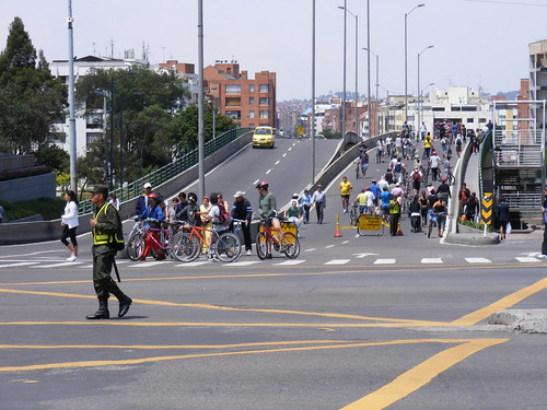 Police officer enforces traffic during Cyclovia.
Finally, in order to promote transit, cycling (and to a lesser extent, motorcycling), the city government has imposes two mandatory car-free days a year, one of which was Thursday, February 11, the first day I was in the city. Buses, taxis, and motorbikes are permitted, but privately owned automobiles were barred from entering the city or driving on the streets if already present.
In addition, private automobiles are also restricted from driving into the city on alternate days based upon their license plate number. Wealthier individuals get around this either by owning two cars (with different plates), or taking out the motorbike instead. The result, therefore, is not perfect (and perhaps an advantage of congestion charges as an alternative), but it does represent a serious step towards curbing auto traffic.
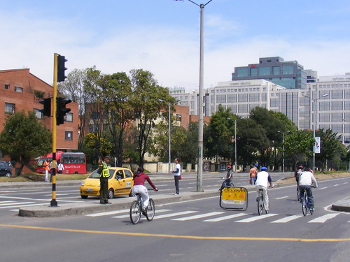
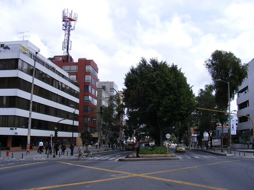
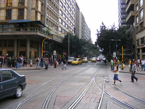
The first picture below show the morning traffic on Thursday, February 11; the second picture shows the same intersection (though facing the other way) on Friday, February 19.
Finally, one of the more curious aspects of Bogotá’s streetscape that I found is pictured below. They appear to be an intentional preservation of disused streetcar tracks at one of the main intersections in the downtown core, and just metres from the entrance to a TransMilenio station. Normally, the presence of disused tracks are a sign of neglect or poor road maintenance (paved-over tracks will often reappear years later, such as those on Bay at Bloor). I thought this, a reminder of the narrow-gauge trams that were abandoned in the early 1950s, and now driven over by TransMilenio buses, was a nice touch.

7 comments
Thanks Sean,
Good piece, interesting info.
Thanks for writing about this!
There’s a great video put together by Streetfilms that I watched not too long ago, about the system, on the 8-80 Cities site. Worth watching:
http://8-80cities.org/Videos01.html
Other cities have “BRT” and “bike lanes” along roads that are generally made for cars, but few have the commitment to a fully separate infrastructure that Bogota has done. Those aren’t bike lanes in the College St. sense. Those are veritable bike highways with dual directions and a clear physical separation from the roadway by a curb.
Likewise, the TransMilenio goes beyond providing a bus lane with some fancy shelters. Those are full-scale rapid transit stations with turnstiles, bike stations and high platforms. Outside, passing lanes allow for the introduction of express buses. The buses themselves are not street legal in the sense that they are fully high floor with two sets of double doors for maximum entry and exit.
Toronto’s inner city doesn’t have wide-enough roads to build TransMilenio-style BRT or CicloVia-style bike highways. The inner suburbs and the 905, however, could implement these fairly easily.
As you may know, the Bogota Parks Commissioner who brought in Ciclovia now lives in Ontario, and even survived a stint working on planning for the city of Mississauga.
so what’s the verdict on Bogota and Transmilenio/BRT, etc.? Should we mimic it in North America? was there pollution? what else?
Peter: I didn’t want to jump to quick conclusions because there’s a lot of differences between Latin American cities and those in Canada and the United States. I intended to showcase some interesting ideas that would be of interest to readers.
There’s no long, drawn-out EA process to build TransMillenio – usually the Latin American BRTs are built by a strong municipal government who can easily brush aside NIMBYs and other complaintants.
There are other cities in North America (besides Mexico City) with high-concept BRTs – Ottawa, Pittsburgh, Boston, Seattle. Here, however, LRT (with POP, rather than fare gates like Latin American systems) have been popular – either street-running LRTs like Phoenix, Houston, San Francisco’s new Third Street Line, or heavy-duty ROW LRTs like Calgary, Edmonton, or St. Louis.
Leonard points out many of the issues we’d have implementing a Latin American style BRT here – we would need “non-street legal” buses, we couldn’t build these corridors in a surface-only configuration anywhere between the 427 and Vic Park and south of the 401 except Don Mills Road (the only downtown route uses a closed-off street). Many of the roadways in places like Bogota or Mexico are built really wide, making construction easier.
That’s not to say that there isn’t a place for BRT in Toronto. One could make the argument that BRT could make more sense than Transit City LRT on some of the suburban corridors. It certainly makes some sense where many bus routes share a common, congested, corridor.
So, like Leonard, I couldn’t see TransMilenio working here that easily, except as suburban corridors like Highway 2 in Durham, Dundas and Hurontario/Main Street in Peel. It would also be competing with the preference for LRT here. (There there are some cases where LRT has big advantages – such as simpler tunnelling as per Eglinton.)
But VivaNext, the centre-of-the-road busway corridors for Viva Phase II will have some smiliarities.
The photographs of the same intersection on Thursday, February 11 (car free day) and on Friday, February 19 speak volumes!