
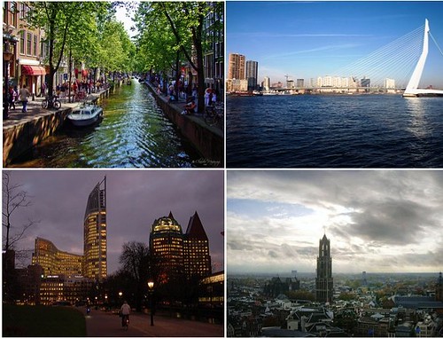
The main urban hubs of the Randstad, clockwise from top left: Amsterdam, Rotterdam, The Hague and Utrecht
During my time in the Netherlands I was particularly captivated by the way the Dutch conceptualize the urbanized heart of their country. The Randstad, or ‘ring city’ is a conurbation of 7.5 million people formed by Amsterdam, Leiden, The Hague, Rotterdam and Utrecht. The shape of the area has been dictated by historical population nodes dating back to the Dutch city states of the 17th century and rests within the geographically consistent, low lying area in the centre of the Netherlands (an area which is called Holland and with which the whole of the country is regularly confused).
Two points emerge as immediately unique about the Randstad. For starters the area consists of a ring of dense urban areas surrounding what is referred to as the Groen Hart (green heart). Whereas in most major urban areas, including the GTA, the focus is on preserving a belt around the city, the Dutch have found themselves in the position of preserving a green space in the middle of their principal urban region, exactly the opposite. Because this green centre affords some of the most convenient real estate in the rapidly growing region there is tremendous pressure to increase development. This is especially true within the smaller towns long established in the area; including places like Gouda. This pressure is counter balanced by the increased urgency for green space preservation in one of the world’s most densely populated countries. As such, the Dutch go to great lengths to preserve the ‘green heart’ even going so far as tunnelling a new high-speed rail line under agricultural areas to preserve the character of the region.
This is obviously an interesting contrast to the GTA where development pressures are centred on a hinterland that can seem falsely endless. While our greenbelt doesn’t have to worry as much about accommodating regional infrastructure needs it may be more difficult to inspire the same sense of urgency felt in Holland. Both green areas however seem to find their motivation in preserving culturally significant pastoral ideals that are important to historical identity.
The Randstad is also fascinating because of the different characteristics of its urban nodes. Each city in the region is centred on a specific function necessary to the Randstad as a whole. Amsterdam is characterized by its internationalism, its culture and creativity; museums and the airport are clustered there. The Hague is a centre for governance, Rotterdam for its port and for industry and Utrecht for its Cathedral and University. Smaller nodes are focused around specific kinds of education and specialized institutions.
At the heart of planning for the region is a national agency of the Dutch Government, the Ministry of Housing, Spatial Planning and the Environment. Planning decisions are carried out on the national scale and are highly regulated by the government with plans being forecast well into the future. Like the GTA, the region faces tremendous future growth pressure and both regions will struggle with where to put new growth and how to service it with transit. The Dutch will be a valuable resource to watch.
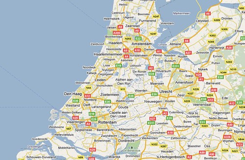
Map of the Netherlands’ urban heartland, the area forming the Randstad
Photos credits in clockwise order: Claudio Mufarrege, Rob Hogeslag, and lambertwn, Map from Google Maps

4 comments
Ottawa’s Greenbelt (Ontario’s first greenbelt, thank you very much) is seen by some as a failure becuase it has encourages sprawl, increased commuting times from the bedroom-community suburbs, greater pollution, and a sense of disconnection between city and suburb. Over time, as Barrie-simcoe becomes the growth engine of the GTA, the same might happen in Southerr Ontario.
Some have proposed developing the Greenbelt (of Ottawa), to prevent sprawl. It is a reasonable idea.
Just a little correction. The caption should read, “clockwise from top left Amsterdam, Rotterdam, Utrecht, The Hague”
It is very important to know which picture corresponds to which urban hub.
Very nice, thought provoking article.
The Dutch government has a grasp of the issues are when it comes to research and policy on development, land use, congestion (having the highest highway density in Europe), transit and environmental management that Ontario and the GTA could benefit from.
(Full disclosure: I have been involved in the creation of English-language documentation for the Ministry of Housing, Spatial Planning and the Environment as well as the Ministry of Transport, Public Works and Water Management, http://www.verkeerenwaterstaat.nl/english/).