

 The Morrish General Store at Kingston Road and Meadowvale; now the home of the Scarborough Historical Society
At the dawn of the 19th century, a road was needed to the east of York (now, of course, Toronto) for settlement and military purposes. Soon after the founding of York in 1793, under the auspices of John Graves Simcoe, roads to the north and west (Yonge Street and Dundas Street respectively) were quickly surveyed and cleared. But the newly-established seat of Newcastle District, the abandoned townsite now found at Presqu’ile Provincial Park near Brighton, required a road connecting it to the capital of Upper Canada. Eventually, such a road could be extended to Kingston and even Montreal.
It was an American land speculator by the name of Asa Danforth Jr. who pitched a successful proposal in 1798 to the colonial government to build such a road. Within two years, his team completed it all the way from the Don River as far as modern-day Brighton (Presquile was soon abandoned as a townsite and Cobourg filled the regional role soon after). Danforth owned land titles in modern Northumberland County and had a vested interest in vying to build this road.
Highland Creek, at the east end of Toronto, was one of several communities that made up the Township of Scarborough. Most of those villages, such as Agincourt and West Hill, grew up along transportation corridors such as early roads like Danforth and Kingston Roads and the later railways. This post is the story of both Kingston Road and one of the “lost villages” that established itself on it.
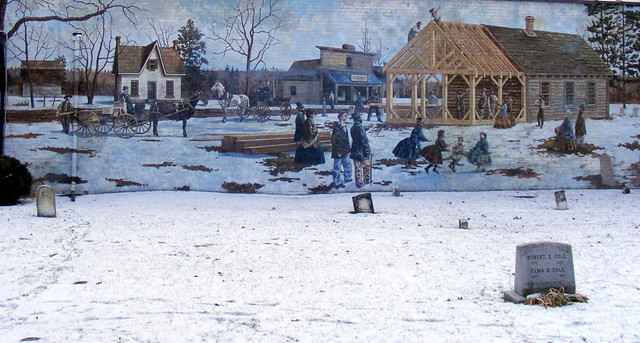 Mural blends the surviving Highland Creek cemetery with a historical scene. The snow in both is a nice touch.
Highland Creek was one of the first settlements established on Danforth Road. Unlike the land near the pre-settlement Lakeshore Road to Burlington/Niagara, the new colony was sparsely settled between York and the Bay of Quinte, and for that reason, the new, yet circuitous, Danforth Road quickly became impassable due to the lack of settlers to maintain the rough trail.
What we now know as Kingston Road was built two provide a shorter path closer to the lake between two sections of the Danforth Road, from the west near the present-day corner of Kingston Road and Victoria Park Drive to Highland Creek on the east. The old Danforth Road remained useful as a farm-to-market connector, until much of the route was consumed by suburban sprawl. Today, Queen Street East, Clonmore Drive, Painted Post Drive and Military Trail make up much of the path of the former Danforth Road. East of the Rouge River, much of the old Danforth Road as far as Brighton later became Highway 2, though some sections near Cobourg were also left out of the newer Kingston Road. Today’s Danforth Avenue was also named for Asa Danforth, but had nothing to do with his original roadway, though it connects with Danforth Road east of Pharmacy Avenue.
Indeed, the local transportation network shaped the history of Highland Creek. While the hamlet, established as a mill site, had an advantage as being at the junction of Danforth Road and Kingston Road, the Grand Trunk Railway built in the 1850s, missed the community by a lengthy distance. The closest station was at Port Union. Later, the Toronto and York’s Scarboro radial carline was built eastward along Kingston Road, but extended only as far as nearby West Hill. Highland Creek did not have a chance to grow as an independent entity, bypassed by the railway and left without the radial service to Toronto.
The Kingston Road became Highway 2, administrated by the Province of Ontario in 1920.In the 1930s, the province converted the narrow two lane road to a dual carriageway (four lanes with a central median) between Birchmount and Morningside (with a flyover interchange with Danforth Avenue/Highway 5). East of Morningside, a new alignment avoided the narrow, steep roadway between West Hill and Highland Creek, with plans to continue the widened freeway as far as Oshawa to relieve congestion along Kingston Road.
Highway 2A was opened in 1947 (due to delays because of the Second World War) between Highland Creek and Ritson Road in Oshawa as a fully controlled, high-speed freeway. Construction included an interchange near where Military Trail and Kingston Road meet, at Lawson Road.
In 1952, Highway 2A was extended to Highways 35/115 near Newcastle and renamed Highway 401 as the first phase of a trans-provincial highway. But with the opening of the Toronto Bypass between 1952 and 1956, the stub towards Kingston Road was re-designated Highway 2A; later intended as the eastern end of the Scarborough Expressway but today, remains very similar to its 1930s design, still unlit with short, shallow ramps and unprotected central median. And even despite being officially decommissioned in 1997 by the Harris Conservative government, Highway 2 trailblazers remain on Kingston Road, while the short stub of Highway 2A, also downloaded, has yet to bear any new name.
While the bypass directed most through traffic away from Highland Creek, it allowed for the preservation of some of the old community’s built heritage. The most striking building from the 19th century is the Morrish General Store, just east of Highland Creek’s core, at Kingston Road and Meadowvale Road and pictured at the top of this article. Highway 2, Kingston Road, remained only two lanes thanks to the construction of Highway 2A and has allowed for a somewhat rural scene in an area inundated by sprawl. Old Kingston Road, the settlement’s main street was redeveloped in the 1960s to serve the new housing surrounding it, yet still has a small town feel. Today, several murals depict Highland Creek’s rural past. One of these murals stands next to the early cemetery grounds, and with a bit of snow, the scene melds from past to present. Highland Creek survives as a neighbourhood name, and the name of the TTC route 38 bus, which passes through the centre of the old village between Rouge Hill GO Station and Scarborough Town Centre.
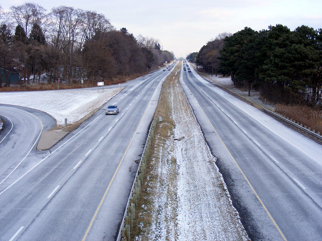
Highway 2A remains true to its 1930s design, unlit, with simple ramps and median. 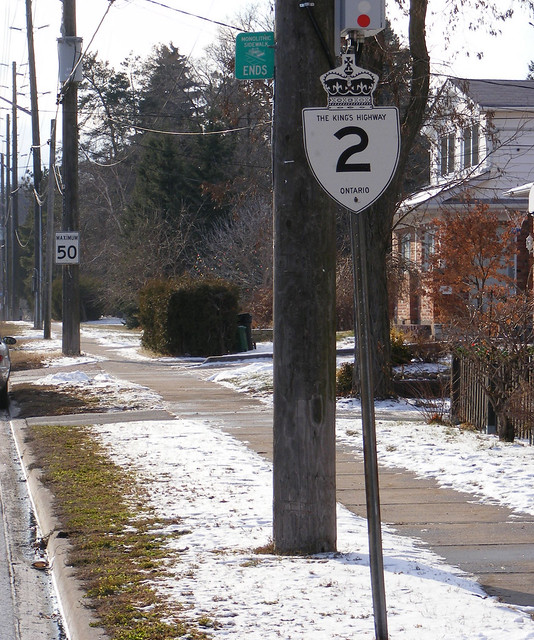
7 comments
Nitpicking here, but wouldn’t being bypassed by the railway and left without radial service to Toronto give Highland Creek the perfect chance to grow as an “independent entity”?
I love these articles which draw attention to early urban settlements in what are now often car-oriented suburbs. Some of these lost villages and towns are still walkable and have pre-1950 heritage architecture, which are two characteristics not assumed to be present in suburbia.
I call that stretch of 2A “Toronto’s Avus” (after Berlin’s pioneering superhighway). Unfortunately, the original late 40s Highland Creek overpass (with provincial crests cast into the spandrels) was demolished for a clumsy replacement a decade ago…
Jarek; this was something that I thought about, but in the GTA, only the strongest, largest communities really survived as independent entities; compare Scarborough’s few small unincorporated villages to the much larger, railway-centred communities of Mimico, New Toronto, Long Branch. Though engulfed in Toronto’s sprawl and losing independent political status in 1967, each has a strong local identity. Being bypassed by transportation links, whether railways in the 19th century or highways in the 20th, usually caused a small settlement to wither and fade.
The joy is finding the links to the past in these largely forgotten locales – it is much easier to do in larger Toronto-area communities that today would not qualify as “lost villages”.
Colonel Danforth Trail is also part of the old Danforth Road
http://maps.google.ca/maps?hl=en&ie=UTF8&ll=43.779708,-79.165077&spn=0.011062,0.01929&t=h&z=16
There are also portions of Danforth Road near Grafton
http://maps.google.ca/maps?hl=en&ie=UTF8&ll=43.987072,-78.015847&spn=0.022046,0.038581&t=h&z=15
And a great online collection of 1880s maps are here
http://digital.library.mcgill.ca/CountyAtlas/SearchMapframes.php
Thanks for this.
Interesting, as from my point of view as an east Scarborough resident, Highland Creek is a lot less “lost” than some of the others that have been covered in this series, especially those in Scarborough. Agincourt is survived by churches and a school, but not much else; Highland Creek has those features and has managed to maintain some semblance of a village core. This I would agree is mostly due to the fact that two-lane roads remain the norm in the area.
Also of note is that, as far as I know, former city councillor Tom Jakobek still owns much of the developable land in the village area. Recent proposals include seniors homes and apartments. I am hoping the village becomes more lively in the near future as nearby UTSC continues to expand its enrollment.
Highland Creek is a great village on the upswing!! The pizza restaurant always has a weekend line up out the door, there’s a yoga studio and wine bar, and the bakery has expanded with a coffee bar and is very busy. I love living and working in Highland Creek!