

There is a spectre haunting the streets of Toronto — the spectre of separated bike lanes.
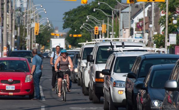
Okay, perhaps it’s not quite that dramatic, but being a bike-riding pinko, I felt obligated to include a reference to communism somewhere. It’s undeniable that the recent talk about cycling in Toronto has been focused on the separated bike lane. And for good reason: one of the key barriers to cycling noted for inexperienced or potential cyclists is perceptions of safety. Traffic is scary. Separate people from traffic and they feel safer. One 2007 study [PDF] highlighted this perception, noting that one minute cycling mixed with traffic was reported by respondents to be 4.1 times as onerous as one minute in a bike lane. The message: provide people with better infrastructure and they will probably cycle more and longer distances.
While many believe separated bike lanes are the bees knees, they aren’t the only way to get this done.
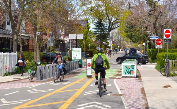
Bicycle Boulevards
Both Portland, Oregon and Vancouver, British Columbia have constructed bicycle boulevards. These are specially marked, traffic-calmed streets that run parallel to major arterials and are designated primarily for bicycle travel. When I first started biking in Vancouver, I was too timid to ride on the busier streets, so I used bike boulevards to get around town until I felt confident enough to ride on other streets. Without these, I may not have cycled as much as I did, or it may have taken me a lot longer to get comfortable.
These streets also have the added benefit of containing small traffic circles instead of four-way stops (and we all know cyclists hate four-way stops). In order to keep car traffic low, they often contain intersections where only bicycles are allowed through. This keeps residential streets from being used as short cuts for cars avoiding arterials, while making them safer for cyclists by limiting car travel and speed.
With Toronto’s somewhat disconnected side streets, however, it may be difficult to find routes that could be turned into bicycle boulevards, especially for east-west routes. But there are contenders, and many of them, like Euclid Street, already contain calmer traffic. Nearby Palmerston Street, which runs in some form from just north of Dupont Street to just south of Wellington Street is a perfect candidate for a bicycle boulevard.
Better, Faster Signal Changers
It took me awhile to figure out that those faded, three white dots on the pavement at intersections were supposed to be signal changers for bikes. The idea is that you rest your bike on top of them and (eventually, maybe, supposedly) the light will change. This only works, however, if you are fully resting on what the City refers to as the “actuation zone”, which frankly sounds a bit scary to me. Adding cyclist light-changers that are bumped out to the curb and have an actual button to push would add visibility to bike routes and, if they’re programmed to make the light change before the turn of the century, efficiency as well. And with buttons there are no actuation zones. You just, you know, push it.
Signs You Can Actually Read While Cycling
I know bicycle routes exist in this city. I’ve seen the tiny blue signs with the numbers on them. But, unfortunately, I have little idea of how they all connect to each other and I don’t think I’m the only one. Better signage would make routes through the city easier to navigate. Paint a bike on the street every so often so that both cars and bicycles know that this is a bike route, and put the bike symbol directly on the street sign for the same reason. At intersections where the bike street turns right or left, make sure the sign clearly indicates that it is doing so (an arrow the size of my thumb doesn’t count). Biking through Rosedale and attempting to find the Evergreen Brick Works, I became lost after losing the trail of the tiny blue signs, and ended up looping around the discontinuous street system. If not for the map on my phone, I may still be biking around Rosedale somewhere.
Contra-flow Lanes
Contra-flow bike lanes, too, exist in the city, but there aren’t nearly enough of them considering how many one-way, switch ‘em up streets exist. While these configurations help to regulate traffic speed, noise, and pollution on residential streets, they don’t distinguish the car from the bike, which produces none of these.
Designating high (bicycle-) traffic residential routes as bicycle boulevards and providing contra-flow lanes where the street switches directions to allow the bicycle to travel through would create a more organic cycling network, better designing the routes people already use. This method is ultimately beneficial for the driver, too. It says, here is where you can expect bicycles, and here, in this painted lane, is where they will be riding on the road.
None of this is to say that separated bicycle lanes on roads shouldn’t be part of the conversation in Toronto. Nor is it to say there aren’t many other ways to improve the cycling network in Toronto (the bike box is one). It’s important to advocate for bike lanes on arterial streets as these are the most direct routes to the places where people want to go, but we need to recognize that a lot of bike travel in Toronto happens on residential streets—especially by the timid and freshly-minted cyclists out there. A good cycling network will be easy to navigate and have a mixture of bicycle boulevards, painted lanes and separated pathways, so that everyone can ride.
photo by Payton Chung
17 comments
The biggest advantage that Vancouver has over Toronto (besides the grid street layout) is the lack of snow.
I have a hunch that snowplowing is why Toronto doesn’t use ’roundabout bollards’ and diagonal barriers to make cycling-friendly side streets.
The points about bike blvds are certainly fair, and yes, these should be implemented where possible. They are a lot less expensive and less controversial to implement, making them more feasible. (You will never see a separated bike lane on Yonge St, for good reason, but Duplex/Jedborough could easily become a Bike Blvd in North Toronto, say). In Manhattan they do not exist simply because there are no north-south streets that are not major arterials, but there are residential streets in Brooklyn that get used for bike routes. They lack the signage and traffic circles though — great idea.
I still think it is vital to push for at least some prominent separated bike lanes in Toronto because to a non-biker, and especially to a cyclist-hating, government-sucks, Ford-worshiping, non-biker they serve as an important visible sign of bicycles as part of the transportation network. The attitudes towards bikes in New York really underwent a sea change when separated bike lanes started showing up in Manhattan a few years ago. Forget the waterfront trails and other improvements – this town went from cyclist death trap to progressive cycling city overnight when 8th Ave got a separated bike lane.
This makes other changes and regulations more palatable because, “sure, we should have a minimum bike parking requirement for commercial garages if there is a separated bike lane sitting there that people take to work… yeah, I guess that makes sense.” That kind of change in thinking will never happen so long as the only visible bikers are road warriors weaving in and out of traffic around delivery trucks parked in their useless painted lanes. Get junior out there in his helmet and guys in khakis and ties cycling to work on a major public street and attitudes will change. Whatever it takes, you need to work to make this image come to Toronto:
http://www.nyc.gov/html/dot/images/bicyclists/ppw_biking.jpg
And this is the sort of initiative that has a least a slight chance of getting approved under Ford.
It’s easier in Vancouver and Portland because of those cities’ strict grid system, but I don’t want to be a typical Toronto naysayer, and I think that Palmerston would be an excellent alternative to Bathurst and Gladstone would be an excellent alternative to Dufferin (if you cut through Dufferin Grove Park). East-west streets are much more difficult, since the only through streets are the arterials. Eventually we are going to have to bite the bullet and build a fully separated dual-way bike lane on one of them.
Great article. There are lots of neighborhoods, especially community calmed ones downtown full of one-way streets, intentially dead-ended blocks and other traffic calming devices that would make for great places to istall bike boulevards. Seaton Village, Cabbagetown, Chinatown and parts of UofTs St. George Campus are just the a few.
All great ideas. There should be some relaxation on rules such as bicycles going the wrong way on a quiet, residential one-way street – the worst places are the one way mazes south of the Annex and up near St. Clair/Oakwood. They are clearly designed to frustrate through motorists, but no thought to cyclists. The same with 4-way stops meant to slow traffic (though they are not supposed to be used as traffic-calming measures). I prefer traffic circles and speed humps to stop signs to calm traffic.
Interestingly, there are special signal-approach buttons used in Ontario; all north of Waterloo – they allow Old-Order Menonites in carriages to push a pedestrian button that’s mounted in such a way so they’re an easy reach.
One problem in Toronto (as you have pointed out) is that the lack of bike friendly east-west routes. We have countless north-south streets that are already comfortable for bicyclists – even though they aren’t designated as “bicycle boulevards”. As you mention, Euclid and Palmerston are examples, but the vast majority our east-west streets are busy arterial roads and most of them are not the most comfortable to ride on.
The other issue is that even on these comfortable north-south residential streets, you inevitably end up having to move over to an arterial road anyway to cross train tracks, right-of-way streetcar tracks, etc. In Portland, you can ride continuously on bike boulevards that aren’t through streets for automobiles. In order to get North of Dupont, you’ll need to get on an arterial road – or end up zig-zagging indirectly to your destination.
I think the city just needs to put some serious thought into our existing bike routes, and connect them better and make them more continuous. Some of these bike routes make sense to be designed as “bicycle boulevards”, some of them aren’t practical, so it may make more sense to put infrastructure on arterial roads.
Right now our bike infrastructure is a patchy mess. All you have to do is look at Google Maps to see how discontinuous it is. It’s designed for people who know the city inside and out and know all the “detours” to comfortably get to their destination. One look at Portland’s bicycle map shows that their routes are connected and continuous.
A good test is to see how easy it is for someone who is new to the city to find a comfortable route to a destination. In Toronto, you will need to study the map to find the patches of infrastructure and routes.
What’s frustrating in the case of Toronto is that there is so much potential for these simple improvements and where they already exist they are scattered and often the result of measures actually aimed at cars. For example, the intersection of Earl St and Huntley St seems to be designed to allow bikes through on Earl, but not so much from Huntley to Earl. There is also a rather nice landscaped bike-only intersection at Moore Ave and Hudson Drive, but my guess is that it was created to facilitate neighbourhood car traffic by having a less complex intersection.
There are a couple of issues, one is that Toronto is great now for bicycle infrastructure with three notable exceptions.
1) Toronto loves the all-way stop too much, and some bike routes currently have a 4 way stop every freaking block.
2) BB’s need to be connected, which Toronto hasn’t been able to do with bike lanes or bike routes. You can’t have a bike boulevard that simply ends at an arterial, because the city hasn’t figured out how to deal with bicycles on arterial roads.
3) You never ever ever go North of St Clair. From St Clair to Lawrence, there is a gradual reduction in bicycle infrastructure, the last of which ends just North of Lawrence.
If you want to see some incredible deficiencies in cycling infrastructure, look to the area around York University, a regional destination. Cycling tends to be popular among university students, but there are no bike lanes or paths on major streets around the campus. It’s just a bunch of suburban high-speed arterials lined with lawns. Also, Spadina south of Front is scary. Two lanes of Spadina lead to the Gardiner Expressway. The one time I rode down there unknowingly, I was lucky that there was a lot of traffic, but it could be deadly. Bike boulevards are a great innovation that we need to know about. But it would be nice to see some planning on solving the biggest infrastructure deficiencies, because it’s just a matter of thought.
Wogster> There are bike lanes all over the former boroughs (they may not attach though)
The sheer volume of tawdry lawn in the suburbs is good news… plenty of space for bicycle infrastructure! Most of the sidewalks aren’t used anyhow, just widen the sidewalk into the lawn-boulevard and presto, cycle track.
Only problem is, it seems that lawns are valued more than flesh and bone…
This idea of the “Tawdry Lawn” is super.
The only one of the four proposed new separated lanes that really makes a lot of sense is something on Richmond/Adelaide, routes first suggested in 1992, put into the 2001 Bike Plan, and supposed to have an EA maybe 2008.
The other roads being suggested might not have the room, and they already have some bike lanes already, compared to fixing up the roads where we ride, filling in some of the gaps in the existing patchwork/notwork, and giving a civic response to the persistent harms and crashes to cyclists on the core east-west roads, where we tend to travel.
Putting bike lanes on Bloor would be a logical thing to do, and it’s been logical for nearly 20 years: direct; flat, lots of cyclists and destinations,no streetcar tracks, and the subway beside that provides both non-car mobility and also a lot of off-street parking as yes, some of the car parking would have to shift a little bit.$200,000 would have repainted Bloor from High Park to Sherbourne five years ago when we first started promoting the Tooker bike lane.
I’m worried about how this newer proposal has surged forward while the Bloor project languishes, and even though there’s a signed contract to do an EA, not only is there months of delay, I suspect the Fordists want to kill it, as it’s also subject to a “report” along with the separated lanes, and a further assessment of the Ford Bike Scheme, which may follow the model of the Transit City makeover.
Installation of approved bike facilities lags terribly; one can’t really trust the City to do a good enough job of design, and installation, (beyond the more normal lack of political will in a carrupt TO). We also need a lot of road repairs and moving beyond just doing things in the very core, and having a more functional cycling advisory committee restored to citizens would help sift through the competing priorities to find a more sensible approach – one that would ask harder questions about winter maintenance, and push for doing the Queen’s Quay separated lane sooner.
I’m also suspicious that the Fordists might use these newer style of lanes to deplete the bike budget, and then only do things in parks, and nada for the urban core, where many of us are, because it’s simple, easy, better….
Bike lanes in the former boroughs, yeah okay a half a block here, then a block there, the entire city was supposed to be covered in bicycle architecture by 2011, according to the 2001 bike plan, city politicians made it so complex and convoluted to get them approved on a block by block basis, that 2011 is here and less then half of it has been built, and I don’t expect it ever to get completed.
What I would like to see is a requirement for sidewalks and bicycle specific lanes in the national highway building code for roads and highways that are built, rebuilt or refurbished. Dirt, gravel and ice roads would be exempted, as would roads that have a right of way narrower then 20m, but they must be prioritized for road use.
Was it just me being crazy fancying about a ped/bike tunnel under the train track at the end of Palmerston, then around the perimeter of TTC yard, linking up with Davenport bike lane and Wychwood park? Oh well, the around TTC yard part may not to practical, but just take me to Christie lane sounds like a win already.
@Yu: why not a ped/bike bridge over those tracks like the one at Summerhill? As it stands, you could use Hammond Place to get to the service road that runs along the tracks and take it as far as Bartlett before crossing up to Davenport …