

Is a grid system the most economically efficient way to lay out a downtown? Last week, I attended a talk by Prof. Robert Ellickson of Yale Law in which he made this argument. The talk was based on his article “The Law and Economics of Street Layouts: How a Grid Pattern Benefits a Downtown“. He was inspired to look into this subject by the exhibit “The Greatest Grid: The Master Plan of Manhattan, 1811-2011” at the Museum of the City of New York last year.
Ellickson contrasted two general models of street creation — bottom-up (created as people build and use the city), which tend to be unstructured (the main US example is Boston), or top-down (laid down by government), which tend to be more structured (most US cities, notably New York). Many cities have a combination of both.
Ellickson based his argument on the higher land values of properties in a downtown grid street system. To be honest, his evidence was fairly thin, so the paper is more a hypothesis than a proof. Ellickson suggested that a grid system is more valuable for three reasons:
- it’s cheaper to build rectangular buildings, in a rectangular block
- there are, apparently, significantly fewer disputes over property lines between owners of rectangular lots compared to irregular lots
- a grid system promotes greater social interconnection and interaction
It sounds plausible, but it would certainly need more thought and investigation before it can be said to be proven. (He says his theory does not address suburbs because they have different incentives and are more purely residential, but that might also be an interesting area of investigation).
The discussion of street grids also inspired discussion of block sizes, on which there has apparently been some work (there is in fact a Journal of Urban Morphology). He argues that there is a sweet spot for block size. Too large, and the land inside the block starts to lose value because it is too far from the street. Too small, and streets start to take up too much of a city’s surface area.
He also looked at changes to street plans — specifically, how often streets disappear. He found that streets are remarkably persistent — once laid down, it is hard to get rid of them, although grid streets are a little more persistent than non-grid streets. Alleys, on the other hand, come and go fairly easily.
An interesting tidbit he shared was that New York’s grid plan specifically rejected ovals and circles in its street plan (which planners often like because they create vistas – think Queen’s Park) because they tend to become exclusive and elite.
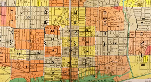
The discussion of street layouts naturally made me wonder about how Toronto’s old street grid developed. It looks to me like Toronto’s was implemented as a top-down grid on the large scale (main streets), but as bottom-up micro-grids, created by the owners or developers, within that large scale. That would explain why so many local streets don’t match up on the other side when they cross main streets. (Lower Manhattan, before the grid plan, was also a series of micro-grids that didn’t connect well).
The discussion also makes me wonder how it would apply to suburbs. They continue the pattern of creating streets bottom-up — largely laid out by developers — within an overall grid. Given the problems caused by their layouts, it’s troubling that streets are so difficult to change. But I also wonder if the economic efficiency of grids, if demonstrated, might encourage developers to explore using them even in suburbs.
Image from City of Toronto Archives
16 comments
A high intersection density, which tends to go with shorter blocks and a grid layout, is certainly more walkable/cyclable and easier to serve by transit.
The province’s Transit-Supportive Guidelines recommends max 120-250 m block lengths as a sweet spot, at least for walkability/transit access:
http://www.mto.gov.on.ca/english/transit/supportive-guideline/layout-local-streets.shtml#local-street-block
Other than the potentially cheaper-to-build rectangles, I doubt the other factors related to economic efficiency of grids would change how developers work in the suburbs, unless there was more demand from the folks buying into those new neighbourhoods…
Some of Toronto’s misaligned intersections, where one street with the same name is not lined up with itself on the other side of the cross street, are not only the result of owners/developers (and surveyors) not conferring with each other, but also of street renaming.
The original blocks of the City of York were laid down by Simcoe. Here’s a picture:
http://en.wikipedia.org/wiki/File:Streetplan_of_the_city_of_York,_Upper_Canada,_circa_1818.jpg
Developers have been slowly moving back to the grid for 20 years or so. Not only do they provide better connectivity, the developer can usually get more lots out of a grid system than from a loop and cul de sac system.
On the flip side, grid systems require a higher percentage of road than a traditional loop/cul de sac system, leaving less total area for development.
Examples can be seen along Ninth Line in North West Mississauga or in the Cornell area of Markham.
The big question for me is what happens to the existing ‘conventional’ suburbs that don’t have the connectivity of a grid system. Is there a way to improve or redesign those areas without destroying the neighbourhood, or will there be enough demand for single detached homes that other factors, like walkability, don’t matter as much?
It is a bit of a misnomer to think of suburban streets as bottom up from large scale developers. Across N. America, new roads are to conform to the roads hierarchy which categorizes roads based on vehicle speed and access needs.
http://en.wikipedia.org/wiki/Hierarchy_of_roads
It’s just about impossible to construct a ‘main street’ in a new area because both major & minor arterials minimize connecting and particularly crossing streets and anything that interferes with speedy traffic.
Particularly evident in newer areas (suburbs) the web of freeways & arterials create a ring of barriers that lock (zoned) residential areas into pods.
The latest tinkering trades reverse lot frontages with parallel streets or cul-de-sacs looping next to arterials, intercepting cross streets. These suburban trends are represented in new arterials in Toronto, like Doris and Beecroft roads, where many homes were torn down to eliminate the grid or the new Fleet Street along Lakeshore Blvd.
As for interior subdivision streets like local roads, minor & major collectors they each have connectivity rules, although many municipalities (Vaughan etc..) have found a way to meet the regs with a semi-internal grid.
Pedestrian and transit planning are almost always treated as cheap add-ons after the fact.
The Province’s 2012 Transit supportive guidelines are pretty good, but like previous guidelines they will have little impact unless they come with incentives or penalties, minimum standards etc..
The Province conveniently exempts itself (the MTO). “Note that the role and function of provincial highways differs from that of municipal roads. Therefore, references to suggested intersection spacing within this guideline are for municipal urban roads.”
And what about urban/suburban sections of the many hostile arterials it runs through towns & cities across Ontario? In Toronto, Provincial arterials like Lakeshore Blvd have been downloaded, but 400 series highways like the 401 and their free flow lanes remain a major barrier to active transportation. I suggest municipalities respond by drafting up some green suggestions for the MTO.
Hi Dylan,
Great article, lead to lots of considerations.
Two things:
I don’t think a grid coming from a developer is really “bottom up”
As for Prof Ellickson’s point that “a grid system promotes greater social interconnection and interaction”, I would recommend that he watch a fantastic lecture by Mark Lakeman of Portland’s City Repair, who argues that the roman grid is the antithesis of social interconnection and community building:
http://www.youtube.com/watch?v=9DGE9BtSK4Q
Lewis Mumford offered some critiques of the traditional North American rectangular grid which I think are interesting. For one, he said that it tends to disregard the natural landscape. So you get steep roads up hills to maintain the straight line on the grid like in San Francisco, for instance. It can make more sense to have roads winding up hills for lesser grades. Creeks and ravines were often filled in to ensure that the grid wasn’t disrupted. The loss of these natural features can make for a more generic urban landscape with less greenery. Also, the rectangular grid often fails take seasonal sun and wind patterns into account.
To elaborate on that last point, he said that a grid that takes into account seasonal sun and wind patterns can mean more comfortable buildings that are warmer in the winter and cooler in the summer.
Washington DC has it right… a grid with numbered/lettered streets with diagonals named after States. Easy to navigate, and the distances can be traversed efficiently.
I grew up in Toronto not to be pedantic, but to be pedantic it is “Lake Shore Bvld” — note space.
Like Hamilton (with Main & King), Toronto needs to make King & Queen one way (for both car and trolly traffic). This could help get rid of that bit of nastiness known as the Gardiner… unless Toronto has the stomach for a big dig (please, no).
In his talk, Ellickson did refer to the fact that New York’s grid effectively obliterated the natural landscape. He also talked about the difference between pure North-South grids and ones that are oriented to a waterfront (such as Toronto’s, which is almost N-S but tilted to roughly follow the waterfront). It’s a good point that an ideal grid should also take into account the local seasonal patterns in its orientation.
I’ve done a lot of research into grids, particularly Toronto’s, but I’ll be brief.
The general grid of Toronto is defined by Queen Street. It was originally Lot Street and had a series of square lots off its north side. The only remaining lot is Grange Park. Many of the borders of each lot are now our ‘arterial’ roads or ‘avenues,’ and a few were originally driveways (eg. Bathurst and Spadina). These driveways and roads developed because of circulation to and from Simcoe’s original ten-block town-site (roughly Front, Jarvis, Adelaide, Parliament). (The 1818 map provided by Jules above is well after Simcoe was gone.) Lot Street itself was established at 90 degrees to the then county line (now Victoria Park Ave). And this straight line of county borders is from the earlier ‘Purchase’ of York from the aboriginals – this area was itself a box. You can find these maps in Hayes, Historical Atlas of Toronto.
At the time of this ‘Purchase’ (1780s), European concepts of territory and governance were changing. Rather than simply holding a territory, sovereigns began attempts to increase the numbers and longevity of its populations. When simply holding a territory, they didn’t particularly care about the layout of streets or blocks, but with the new concern for increasing populations, they began imposing squares and grids — this opened up areas to disperse disease, allow for the circulation of goods and people, and easier to police. In fact, at the time the concept of ‘policing’ and ‘urbanizing’ were essentially the same since ‘police’ then meant pretty much the same as what we mean by ‘community’ now.
Anyway, I’d argue the key factor with grids and economic development is circulation. This was the case at York’s founding, and similarly the case roughly 200 years later with Jane Jacobs’ arguments for short blocks in Death and Life.
The counterexample in Toronto is Rosedale, which doesn’t follow a grid pattern – the results are (some would say deliberately) anti-urban.
The radial street plan is another variety of top-down street planning. Karlsruhe (one of Germany’s most beautiful cities) is probably the most famous example:
http://www.orangesmile.com/common/img_city_maps/karlsruhe-map-0.jpg
Power-hungry monarchs are partial to radial designs, as they can locate their palace at the point where all the major roads in town converge. In Karlsruhe, look for the baroque, w-shaped ‘Schloss”. The king becomes the centre of the universe! This is definitely not an efficient use of urban space – but efficiency is the least concern of pompous royals. In contrast, I’d say that grids are more democratic.
Patrick – Rosedale (and Lawrence Park) were built much later, notably after Toronto had heavily industrialized and the city was pretty disgusting. Rosedale is largely based on Ebenezer Howard’s ‘Garden Cities’ ideals – more accurately, those who took up some of Howard’s ideas to develop leafy suburbs without Howard’s more radical economic reforms.
Michael – Karlsruhe is a fantastic example of town planning during the earlier form of sovereignty I pointed to above: maintaining a territory. Thus, they sought to situate themselves in the centre, with all roads leading to/from them. If you’re interested in reading more about this arrangement of urban space in relation to sovereignty, have a look at the first few lectures in Foucault’s _Security, Territory, Population_. It’s not particularly hard to read, and quite interesting.
Facebook fameuse George Takei recently publicized a *graphic* example of the difference between New York and Boston’s roadways, from an arial and ground-level perspective: https://www.facebook.com/photo.php?fbid=601884693174321&set=a.223098324386295.105971.205344452828349&type=1&theater