
As many Spacing readers know, I have a deep love of maps (both reading and making). And I also have a deep affection for Willowdale, the North York neighbourhood where I grew up. So it was exciting when the curators of the art exhibition “Oh Dear” approached me about contributing to the site-specific show in “downtown” North York.
My installation is called the “Willowdale Transit Authority” and is conceived as a fantasy subway map for Willowdale as if it were a booming metropolis (the map is 12-feet wide, 7-feet high). I used some of the most distinct features of Willowdale — parks, schools, landmarks, plus former civic leaders — as inspiration for the lines that make up the subway network. I included every elementary, middle, and high school in the neighbourhood, as well as every park and parkette, with the exception of Silverview Park (I just couldn’t logically fit into the Parks Loop Line). I made every attempt to situate each of the “stations” as close their actual location.
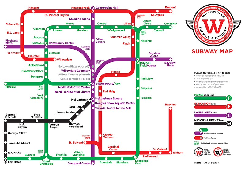
To see a large version of this map please follow this link to the Spacing Flickr account.
When I showed the map to my high school friends (carpe diem, Earl Haigers!) they proceeded to debate the boundaries of Willowdale with me (those that lived outside of my definition took great, and sarcastic, offense). My boundaries for Willowdale are more historic in nature: Highway 401/Sheppard to the south, Steeles to the north, Bathurst to the west, and Bayview to the east (Canada Post’s Willowdale includes Bayview Village, Bayview Woods, and all areas east to Don Mills Ave.).
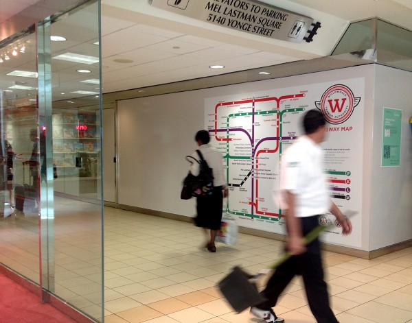
The map is located on the lower level of the North York Centre, near the bottom of the escalators, and attached to the exterior of the Metrolinx regional office (which is a wonderful coincidence).
During the map’s installation — and subsequent visits to the site — many people have stopped to explore the map. Some get the idea right away; others are totally confused and think the map is the real deal. I had two Metrolinx staffers tell me they spent 10 minutes staring at the map wondering whether it was a plan for the future (this was both funny and shocking: as employees of the GTA’s transit projects wouldn’t they know the answer to their own question?).
10 comments
This is awesome, Matt! I live in North York, I’ll have to go take a look at the installation in person! Carpe diem, my friend 🙂
Nice work, Matthew!
Who’s to say some of those routes cannot be incorporated into a bike lanes/bike paths plan.
Do you also get wistful over the unbuilt Willowdale station on the Sheppard line?
Cheers, Moaz
Matt, I would love to get a poster of this map for my apartment! Can it be made available for such a format?
Great map Matt. Brings back many memories of my 30 years in Willowdale .
I would buy this poster (smaller size), if made available for sale! LOVE IT!
Great piece Matthew. Shame it does not include Glendora Park, Glen Avon school for us Willowdaler’s below Sheppard, north of the 401. Good memories on the map (Willow theatre, nice!)
Simon: Glendora is included in the parks line.
You left off Gwendolen Park in the SW corner of Willowdale
http://goo.gl/maps/tM6hj
Tom: I’ll add in that park when we do prints of this map. Gwendolen is such a small park it was easy to overlook.
So creative..and so many memories. Unfortunately didn’t include the little parkette on Alfred Ave (would have been great to jump on a train from there to Haig back in the day)! I would also get a poster if available.