

![]()
Special Guest Post by Jonathan Cote
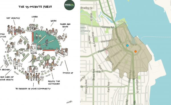
The City of New Westminster is currently working on its Master Transportation Plan. The plan is looking at aggressively pursuing a 50% sustainable mode share(walking, cycling & transit). This map was developed to better visualize the connection between land use and transportation planning.
We went through two iterations. The first map that was developed showed all of the area’s in the city that were within walking distance of a transit stop. Ultimately, we found that the latter was not that useful, because it highlighted more than 90% of the city.
I then came across Jared Walker‘s book Human Transit, this past summer. The book really highlighted the elevated importance of the Frequent Transit Network and got me thinking on how we could transform the walkshed map into something that might be more useful from a planning perspective. We changed the original map accordingly.
The policy implications on how this kind of map could be used have not been fully explored yet and I would be very interested to hear feedback from your readers.
The one concept that is currently being looked at by the city is applying different parking standards based on this map. Currently, the city applies the same parking requirements throughout the city.
***
Jonathan Cote is the co-chair of the Master Transportation Plan committee and city councillor at the City of New Westminster.
One comment
The New Westminster bus network is needlessly complex and infrequent. On average, the bus routes are twice as close together as they are in Vancouver so service is spread thinly. The two most frequent routes are too close to eachother – their coverage areas overlap.
The flawed network stems from a likely well-meaning “minimize walking distance to transit” objective in the previous transportation plan. This results in nearly useless infrequent routes spaced closely together instead of much more useful frequent routes within walking distance of everyone.
New Westminster bus network could be designed so that 90% of its population is within walking distance of frequent transit just by rearranging the streets that the routes run on. That’s what needs to happen if New Westminster wants to achieve the mode share objective stated above.