
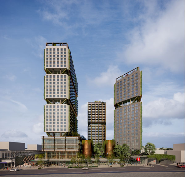

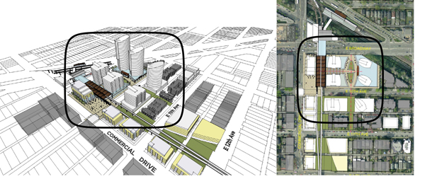
Last week, the proposed development in the Featured Image above, located at the Broadway and Commercial “Safeway Site” (BCSS), was referred to public hearing anticipated for July (consequently, while many are on vacation). The project is designed by a highly respected architect working with a creative developer who has delivered many innovative, industry-leading, projects. The proposal includes three towers, with heights ranging from 24 to 29 residential storeys sitting atop a series of “plinths” (or thicker bases) that add 9 more storeys: the tallest tower rising effectively to 38 storeys.
On the face of it, the proposal complies with a specifically referenced density of 5.7 FSR (or “floor space ratio” expressed as a multiple of site area) in the Grandview-Woodland Community Plan (GWCP), approved in 2016. However, the proposal is inconsistent with the council-approved site plan diagrams that staff included for this important site in the GWCP.
To see how we got here, and critique its value, it’s worth understanding the site’s public process history and related form of development refinement over time.
Grandview-Woodland Community Plan & Broadway and Commercial “Safeway Site” Public Process History
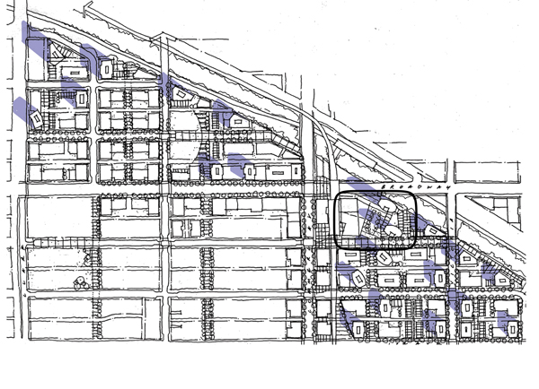
The Grandview-Woodland Community Plan was approved by the previous city council in 2016, with community stakeholders who helped shape the plan now monitoring implementation through market-driven redevelopment. Before this time, the Grandview-Woodland community initially suffered through a difficult public planning process that imploded over tower heights for the BCSS, ultimately contributing to the dismissal of the previous council and giving rise to the current council who must now vote on their referral. As such, it’s important to understand what led to this.
The image below was produced internally by the City of Vancouver in 2013. It was obtained through a Freedom of Information (FOI) request as it was never made public. Staff was instructed to “max out towers” with this drawing depicting 22 towers arranged along or near the Grandview Cut between Clark Street and Victoria. Two towers are shown for the BCSS.
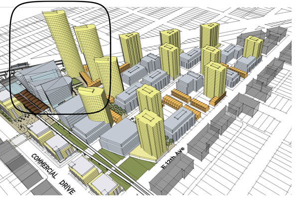
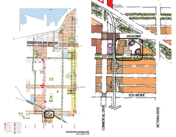
A reduced version shown below was ultimately released to the public as “Emerging Directions”, identifying half or 11 tower sites across the same area, including two for the BCSS.
The Emerging Directions recommended heights for the BCSS towers at 34-and 36-storeys. Both towers were intended to be proportionally slim to minimize view and shadow impacts. Here is the city’s urban design modeling (also obtained through an FOI request) that visualizes the Safeway Site and other nearby taller building sites, under the 11 tower proposal. This work was presented to the public with a disclaimer that further urban design analysis with respect to shadowing, place-making, scale and legibility, adjacencies, and other aspects was required. The proposed heights were measured from grade and included lower commercial volumes for a new food store.
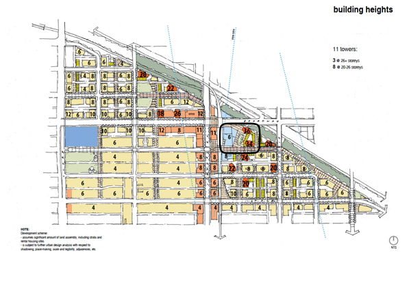
These heights, in turn, produced a community uproar causing the City to further reduce heights under the Grandview-Woodland Draft Concept Plan, to 22 and 28 storeys intended to be inclusive of any plinth/podium associated with a food store at grade (thereby allowing 20 and 26 potential residential storeys above assuming a 2-storey food store volume).
The GW public process imploded soon thereafter giving rise to the Citizens Assembly (CA), a 48-member council-appointed committee charged to address the backlash against the 22- and 28-storey heights for the BCSS. The CA released their report in June 2015 recommending low to mid-rise forms (including a single 12-storey building for the BCSS). It’s important to note that the City, at that time, did not agree with the Citizens Assembly (CA) with respect to the Safeway Site given Transit-Oriented Development (TOD) adjacency potential for such a large assembled site.
This brief history provokes many questions, but one is particularly relevant: How did the current 33- to 38-storey proposal achieve its referral to public hearing when it is taller and denser (including an additional tall 3rd tower) in comparison to the earlier less dense 34- and 36-storey concept investigated by staff and summarily dismissed by the GW community, let alone the 22- and 28-storey proposal that brought down the GWCP process, and ruling party, making way for the current council?
It is worth emphasizing that the tallest of the proposed three towers now referred to public hearing is 10 storeys higher than the heights that caused the Grandview-Woodland Community Plan process to be suspended. Further, it is 26 storeys higher than the Citizens Assembly preference for a dense mid-rise strategy.
It is also hard to understand why this tall, three-tower proposal, is approaching the height of the Woodwards development which is only 52 feet higher—defensible for its downtown context at 407′, but questionable for taller buildings to be built under the GWCP given such a fractious process history.
Let’s try to understand how such a public process disconnect has occurred with Council now forced to consider a development that includes a 3rd tall tower at an overall density well above the GW community’s expectations. Technical staff, who were producing urban design studies in support of the Grandview-Woodland Community Plan, were also aiming for substantively less density and only two towers. A bit more Safeway Site process history is necessary.
Early BCSS Enquiry Advice
Urban design engagement with the GW community reaches back to 1999 (actually before this but we’ll start here) when stakeholders contributed to design workshops that co-developed a Broadway Commercial Station Area Plan motivated by Millennium Line investment. Here are a few products from this work including drawings by former Director of Planning Ray Spaxman, highly respected architect and urban designer Norm Hotson, the city’s Senior Urban Designer Frank Ducote, and myself.
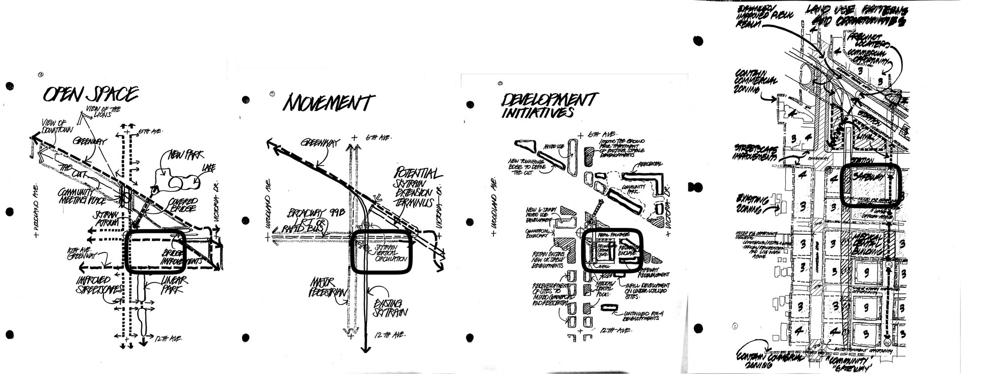
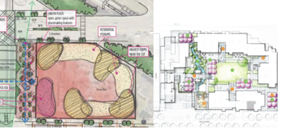
A key finding from this important co-design work was an emerging preference for a sunny public piazza on the northeast corner of Commercial Drive and 10th Avenue that would be activated by transit patronage and adjacent commercial frontages to the north. Over many years, the City’s Urban Design Studio continued to develop this public amenity in anticipation of substantive Community Amenity Charge (CAC) collection associated with new station area developments that would collectively help secure and develop this location as a vibrant “community heart”.
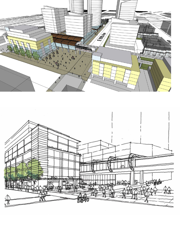
In 2006, building on the 1999 station area planning work, the City—in partnership with Translink—co-funded a study to identify Expo Line Station Improvements. Coincidently, this was produced by the same architectural practice who have designed the three-tower development referred to public hearing. Perhaps not coincidently, the consultants initially proposed 3 towers for the BCSS site as shown below.
City of Vancouver Planning staff, acting as the client for consulting services, did not agree with three towers for the site size as assembled and owned by Safeway. The final draft of the consulting report was specifically revised to allow only two towers as shown on the image further below. It is worth noting that this rejected three-tower development, recommended by the same architect 16 years ago, is very consistent with the form of development referred last week.
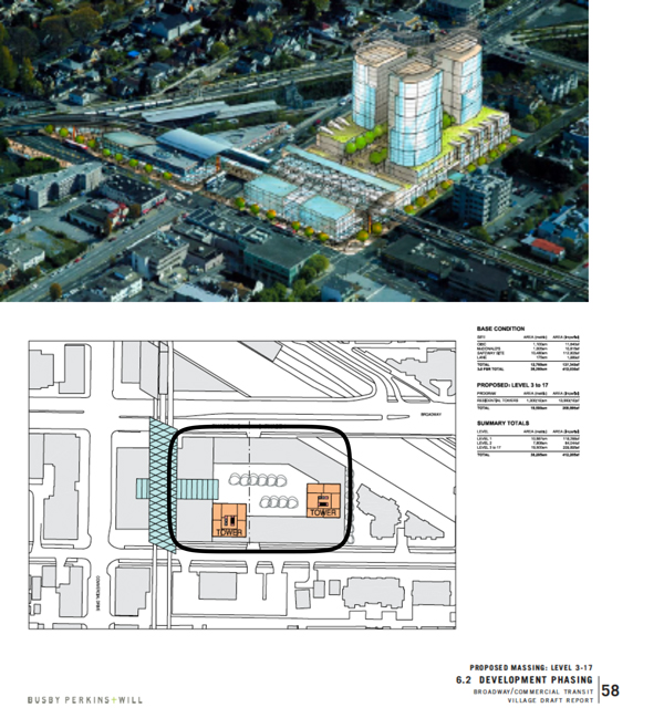
Moving forward into the Grandview-Woodland Community Plan, as well as the politically necessary Citizens Assembly process, staff remained consistent in their support for two slender towers of relatively modest height. The images below are representative of staff’s investigations between 2013 and 2016 that assessed multiple food store footprints, and related phasing implications within the site, as well as Safeway’s preference to include a high percentage of office uses stacked above their food store. This was done in response to the recognized best TOD land-use practices of the day.
Tower heights were capped at 24- and 28-storeys, as counted from the ground up: that is, inclusive of a new food store volume/plinth. The Commercial Drive and 10th Avenue piazza, as introduced in 1999 and further developed for the next 17 years, is also shown.
This important technical work reflected specific development preferences expressed by Safeway until their acquisition by Sobey’s, including the store size, phasing, and potential foregone revenue during the construction period towards a new, modernized food store. Staff worked closely with Safeway’s architect and the store’s head office to understand the complexity of this mixed-use development, and related economic considerations, towards a viable proforma.
The work at that time was therefore grounded in the reality of the landowner’s development program with an understanding of what was required to ensure that redevelopment occurred. The viable density reflected in these images was 4.5 FSR and would enable 475,000 square feet of new development, including office use immediately adjacent to the station, and a large-format food store. This development potential for the BCSS was intended to be enabled in the approved Grandview-Woodland Community Plan. Mixed use development, carefully scaled at 4.5 FSR with two slim towers of moderate height, would be considered.
As previously noted, senior City Hall leadership did not agree with the lower mid-rise heights recommended by the Citizens Assembly. Staff, ever mindful of the community’s preference for lower scaled form, and the necessary required density to trigger development for the BCSS, continued to refine the station area’s urban design to not over reach, or under reach, on density and scale.
Given the TOD adjacency and the importance of the station location within the transit network, staff believed that there was an aggressive, yet defensible, urban design rationale for two slender towers up to a maximum of 24- and 28-storeys (assuming conventional floor-to-floor heights for the ground commercial tenancy and residential floors above).
At the time, staff did not support greater tower height. The slender 24/28 storey height was well understood: it would not overwhelm the immediate station area scale, and would leverage the prospect for other nearby sites to have similar towers towards a hierarchy of descending taller forms that, as a collective, would mark the Broadway-Commercial Station Area within the urban landscape.
Staff strongly believed that such “compact tower bundling”, with adjacent/nearby landowners enjoying similar entitlements, to be a fair offering under the Grandview-Woodland Community Plan, and lead to viable development on multiple sites towards greater residential capacity. Balanced tower spacing across all contributing sites was, therefore, an important determinant when considering the Safeway Site development, and a particular reason why only 2 towers were preferred by technical staff. It’s worth noting that a 3rd slender tower may be possible on the adjacent site to the east of the BCSS that is not included in the current rezoning ownership/referral.
Importantly, the BCSS was never to be considered as an “island” unto itself, but rather as a catalyst to a station area development market to be enabled by the GWCP. The important aspiration was neglected during the Safeway Site development inquiry process, producing a uniquely distinctive development approach that could not be extended to other landowners/sites towards a larger “sum of the parts” urban form intention. Technical staff always wanted to ensure an optic of “development equity” towards other nearby landowners.
Ultimately, staff produced the following final representative diagram/image for inclusion in the GWCP. This work is consistent with the previous investigations noted above while taking greater advantage of streetwall development potential along 10th Avenue to the south, and Broadway to the north.
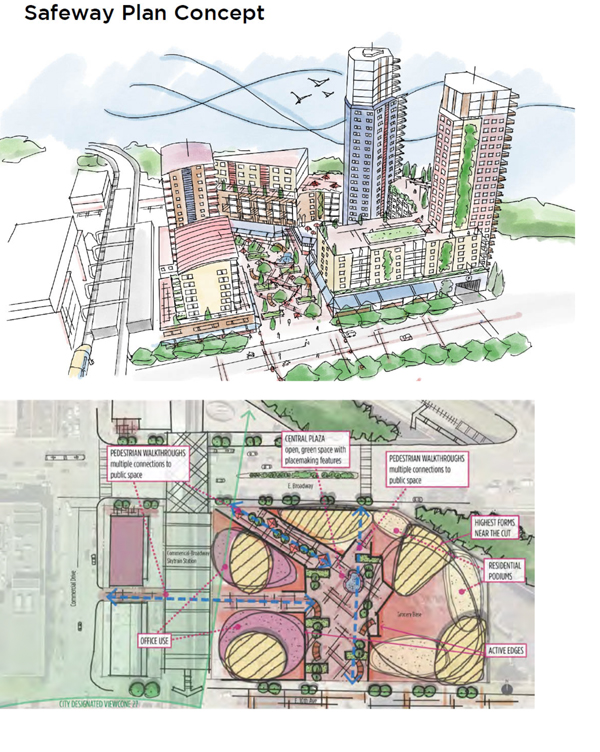
This thoughtful representation “breaks down” the overall massing into a series of distinct pieces that shape a human-scale environment. Public open space is at grade, accessible from multiple locations, and pays attention to building shading while mitigating the ambient Skytrain and automobile noise. While still not consistent with the Citizens Assembly’s preference for a lower form, this image seeks an “honorable scale” that is attentive to the GW community concerns, notwithstanding the two proposed slim towers also shown.
Staff believed these images were therefore defensible when Council was to consider the final Grandview-Woodland Community Plan. They accurately represent and summarize over 17 years of urban design investigation for this important site, with the community piazza to be located at Commercial Drive and 10th Avenue as previously emphasized. The work was intended to be the “comparative assessment standard” when advising market development inquiry, as well as technical policy context for Urban Design Panel consideration to ensure proposals meet the intent of the Council-approved GWCP. This clearly did not happen with the proposal that was referred to public hearing.
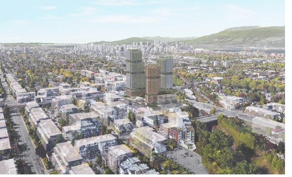
So why does the current proposal below, differ so substantially in form and scale?
This is where things get fuzzy. It appears that the two-tower rendering produced by staff, with thoughtful urban design merit described above, was intentionally left out of the final version of the draft Grandview-Woodland Community Plan. It is also curious that a second alternative site plan diagram was added, presumably at the instruction of senior leadership: one drafted just prior to finalizing the GWCP and substantively different than that supported by technical staff who were more directly involved with the community, and who had thought about the site’s development potential for 17 years.
Full disclosure: I left the city in 2014 which is why I am unsure of what occurred afterward. The GWCP site plan diagram (on the left) that was added late in the process, appears to be specifically representative of a development inquiry for an alternative, denser and taller, 4 tower concept shown on the right.
Such diagrammatic coincidence, perhaps reflective of private development inquiry occurring outside the Grandview-Woodland public process at that time—with 11th hour policy plan revisions tailored to apparently accommodate more specific market-driven development forms—understandably feels suspicious. Additionally, the very specific allowable density now stipulated in the GWCP at 5.7 FSR appears arbitrary, especially when the preferred technical staff approach, based on years of testing while collaborating with the landowner was understood to be no higher than 4.5 FSR. The FSR difference of 1.2 for this large site equates to an additional 126,830 square feet. This additional density overreaches.
It is simply hard to know for sure what happened as the final strokes of the Grandview-Woodland Community Plan were concluded and sent off to a potentially unknowing Council for approval, and if any urban design testing, of what might have been a purely market preferred higher density, even occurred before concluding on this potential. Did senior staff simply accept 5.7 FSR without question?
And now, a second development concept, that packs the “allowable” 5.7 FSR into three tall and thick towers, has been referred. I believe that this public process moment, resulting from a compounding series of errors, has now put this council in harm’s way.
Food for Thought
It is both fascinating and painful, to observe transient bureaucracies that are influenced by 4-year election cycles when city building (and community plans implementation) occurs over long arcs of time. Corporate memory can evaporate overnight leading to a certain “disconnect” that further widens the breach of public trust. Public process forensics can remind us of our systematic challenges to help us better coordinate such important work in service to the taxpaying public, and improve how we advise the market that delivers new developments to accommodate growth.
Important sites such as the Broadway and Commercial “Safeway Site” demand transparency, rigor, and sensitivity to ensure that all stakeholders remain informed of policy intentions so that there are no downstream “surprises” as with the current application.
The three-tower proposal that was referred last week, while “complying” with the GWCP’s curious 5.7 FSR, is a much different project than the urban design staff’s preference for two slender towers at 4.5 FSR. This challenging public process moment, which will culminate in Council approving or rejecting the current proposal, is an instructive lesson on why it is never a good idea to enshrine particular development inquiries as a matter of public policy. Sites are sold and different land owners/architects have different ideas.
Common sense suggests that whatever is ultimately built should not be worse than the proposed heights that imploded the Grandview-Woodland Community Plan process (while appreciating the Citizens Assembly’s preference for mid-rise buildings). Given this public process context for the Safeway Site, three very tall and thick towers are clearly worse than two very tall slender towers. It is the job of staff to immediately inform the development community when they overreach. Did staff do this, and if not, why not?
Further, the urban design work produced internally by the City well before, and during, the Grandview-Woodland Community Plan process should have shaped any related market-driven development inquiries to set proper limits, not the other way around—if this is what happened. The current proposal should have been dismissed at the first inquiry meeting leading to further exploration of viable approaches that could deliver better project scale, and public amenity sought in the GWCP. Just as urban design staff had done, on behalf of all stakeholders including the market, for many years.
The enormous amount of generously offered social capital, that is necessary to develop (and politically justify) Community Plans, only matters if they are honorably implemented. Community Plans should strive to clarify land value expectations, reflective of specific amenity obligations, for large/strategic sites. Such sites must have inherent limits so that we understand when any proposal “over-reaches”, or we have no politically defensible system of rewarding the market with density and height through regulation.
It appears, in this unfortunate case, that specific market interests may have influenced the allowable density outside of public processes that had already suffered a breach of trust three times (Emerging Directions, the Draft Grandview-Woodland Community Plan and The Citizens Assembly recommendations). Will there be a fourth?
I do not envy City Council.
***
Scot Hein is a retired architect, former senior urban designer at the City of Vancouver and the University of British Columbia. He is an adjunct professor of Urban Design at UBC, lecturer at Simon Fraser University and founding board member of the Urbanarium.
One comment
I was at the civic meetings at Trout Lake, in the early 80’s, over development at Broadway and Commercial. 5 decades and nothing’s been done. Something’s wrong with this process. It’s our Grand Central Station and it should be treated as such. Enough with the nimbyism. It’s going to look ridiculous having short building’s at the centre and 50 storey buildings, across the street, on the borders of the Grandview/ Woodlands precinct. Take the community contributions and let her rip. Get on with it!