
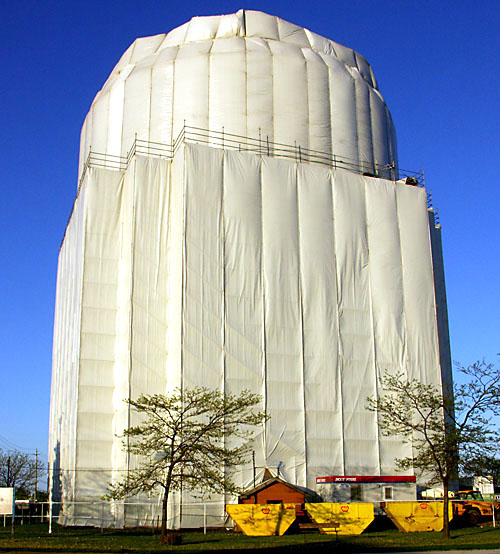
On his great wandering Toronto blog Dodgeville, Val Dodge just posted a picture of what could be Christo’s latest project at the Eglinton and Warden water tower. In the upcoming issue of Spacing (out in late June) we have an article on how water towers around Toronto are neighbourhood landmarks. I wonder how many people in Scarborough have suddenly taken notice of a piece of infrastructure that had become familiar and unremarkable background landscape.
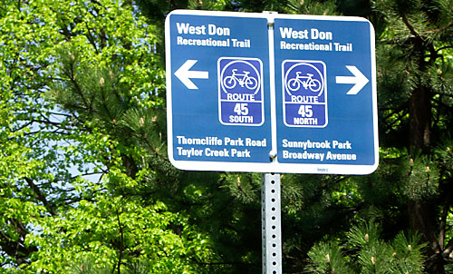
Also on Dodgeville are pictures of the new wayfinding signs in the Don Valley that I first saw last week on an evening ride up to Sunnybrook. They look nice (though as Val points out, the North-South arrows are pointing in the wrong direction here). Maybe one day I’ll figure out what all the route numbers mean and where they go — up until now they simply afford the mildly safe feeling that you’re on somebody’s official route.
Update: Further poking through Dodgeville reveals this examination of how the Canadian Tire at Main and Danforth behaved after they promised to make their new store store fit into the surrounding urban fabric. A cautionary tale as Leslieville gets ready for the possible arrival of a “smart centre” big box development on Eastern that also has promised sensitive design.

8 comments
The bike route numbers are set up in the same manner as the US Interstates (or Quebec Autoroutes, which copied the Interstates, even in its shield style), believe it or not.
Even routes are east-west and increase as one goes from Lake Ontario to Steeles. Odd routes are north-south and numbers increase from Etobicoke Creek to the Rouge River. The city-issued bike maps have these numbers. I find the placement of the signs to be useful (route junction before the intersection, rassurance signs along the routes). But I like now that destinations are slowly being added to the signs, something that I’ve seen in Chicago and San Francisco, which are more useful than numbers.
Though this is slowly being rolled out, starting with downtown. I’d like to see the city try to attempt to have continous numbered routes out in North York, bike lanes or not! The system is reliant on bike lanes and continous quieter roads (like Duplex Avenue), but these routes are often plagued with 4-way stops (which technically bicylists, like cars must come to complete stops).
They do something similar in Stockholm — they give destination points in terms of distance. Very helpful for things like transit stops, neighbourhoods, or markets.
It’s a very intuitive — European — way of navigating. You go from one landmark or neighbourhood to another. It matches the way most non-map-geeks think.
About the Main & Danforth Canadian Tire – it’s truly horrible, and the new one being built at Lakeshore & Leslie looks like it’ll be exactly the same.
Rather sad they tore down the Eastern Stub of the Gardiner and all the new development is geared around cars. Think of people. Oh won’t somebody think of the people!
The Canadian Tire on Lake Shore is built right out to the sidewalk, a quasi-urban concession, and is in keeping with its location on a highway that happens to have traffic lights and a pedestrian crosswalk. I would urge people not to treat Leslie and Lake Shore as if it were the Champs à ‰lysées; it’ll be an industrial highway for the rest of our lives. (What would you really prefer there? A nice artisanal coffee shop?)
The Version 2.0 of the Foundry District may or may not “promise sensitive design.†All that’s been shown in public are twee little faà §ades along the main streets, incorporating 60 units of housing that are impossible under any existing zoning. Inside? A sensitive, tidy, human-scaled, eco-friendly 700,000 square feet of big-box stores (Sherway Gardens is ostensibly only 500,000), accompanied by 1,900 parking spots. I have all the notes (and all the drawings on Flickr). Research first, please.
All necessary research was done for that paragraph that had the sole purpose of directing readers to an examination of the Main/Danforth Cdn Tire that may be similar to what might happen on Eastern Ave.
Thank you for a link to all the notes, they are extensive and useful (research lets me say this).
Just because Lakeshore between the DVP and Woodbine is an expressway now doesn’t mean it always has to be, or should be.
Woodbine (what Lakeshore turns into when it turns north at the Beaches) is more of a human-scaled street – with homes and businesses.
Lakeshore East should be atleast be built so that main entrances of stores are on Lakeshore (why can’t drivers park behind the store and walk around to the front? Too much exercise? ) And who’s to say that it won’t change? If the trees planted along each side and in the median survive (tough with all the car exhaust), it’ll be a great place to be outside in the shade on a hot summer day, watching cyclists pass by on the Martin-Goodman trail.
It’s not unreasonable to expect more on Lakeshore – it’s smack-dab between the Ashbridges Bay Park / The Leslie Street Spit / and the future Portlands neighbourhood and the nice neighbourhoods of Queen & Broadview and Leslieville. It’s a barrier at present, and bad architecture won’t make it better … but good architecture might.
Simple solution – tax parking lots, both free and pay, highly, and not just downtown and North York as Mayor Miller has suggested – everywhere. And make them plant a shade tree for every so many spaces or square feet.