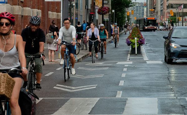
The Toronto Coalition for Active Transportation has released a brief report benchmarking the City of Toronto’s cycling programs against other cities (such as New York, London, Portland, Seattle, Chicago, Vancouver, Montreal). Toronto, as expected, is lagging behind its counterparts somewhat (although to be fair some of the comparisons are with the best cycling cities in the world).
Coverage of the report focused mostly on the total distance of “on-street bike facilities” (the report doesn’t define what that means exactly, so most coverage confused this number with bike lanes proper, which are in fact much more limited). Toronto’s performance in this category is middling (214 km, of which only 76 km are actually dedicated bike lanes), but it falls behind its Canadian big-city counterparts when that number is compared to the total size of the city.
The report also compares cycling spending per capita with other cities, and cycling’s share of total commuting trips, where the city again falls behind Montreal and Vancouver (although, to be fair, Vancouver has not been amalgamated with its suburbs. The share in the old central City of Toronto is probably more comparable to Vancouver). Finally, it ends with an interesting comparison of gender shares of cycling (Amsterdam is the only city where more than half of cyclists are women. In Toronto, almost two-thirds of cyclists are male).
Read the full report (PDF, two pages) to see all the detailed numbers. TCAT is working on developing a more comprehensive report.
The report was released in conjunction with TCAT’s Bike Summit 2008 held Friday April 25, which brought together all kinds of cycling experts and advocates. Podcast interviews with some of these participants can be found on the Sounds of Sustainability website (see April 28 and April 23). I found the interview with Koy Thompson of the London (UK) London Cycling Campaign quite interesting in relation to the situation in Toronto.
Photo by Steve’o.


9 comments
There is a lot of slush in these numbers. It’s not really useful to lump together all on-street bike lanes, for example. There is a huge difference between those that are between traffic and parked cars (99% of all on-street lanes here in NY) and those that are between parked cars and the curb (3 blocks worth). Which kinds are in which cities? I was biking around Manhattan (literally) last weekend, and I can tell you that on-street lanes mean nothing in New York where double parking is so endemic that even the cops casually do it. Bike lanes just scream to be double-parked in – how convenient! It’s insanely dangerous when forced to constantly swerve out of bike lanes into fast-moving car lanes in Harlem, for example, where the livery cabs love to honk and sideswipe you.
On the plus side, New York has off-street waterfront bike trails that would make Torontonians drool. The sheer density of bikers along, say, the Hudson River bike paths (dedicated lanes for bikes and bladers only, with smooth asphalt and granite curbs and an average speed of 10-15 mph) puts the busiest part of Martin Goodman to shame. The momentum here is great and the city is doing a terrific job stitching together these trails, just not on the streets themselves.
If any of you ever come to New York and have access to a bike, email me at uskyscraper(at)gmail.com and I’ll recommend some terrific recreational routes along the water, over and under bridges and through Central Park, Randall’s Island, Inwood Hill Park, etc.
Progress on bike infrastructure here has been incredibly slow.
However, there are some signs of movement.
Finally, this summer we get a bike station at Union Station (another is to be built at Vic. Park Stn by 2010)
Also, I noticed the first bike lanes report of the year has made it to the public works & infrastructure committee.
It only provides 3 new bike lanes, but its a start, finally the Wellesley lanes are coming forward.
Much more needs to happen here.
To Uskyscraper’s point – Will Scarborough ever get a meaningful waterfront trail?
And where are the commuter trails for the Finch and Gatineau Hydro corridors?
I would like to know whether 76 km refers to 76 km of streets on which there are bike lanes, or whether it refers to 76 bike lane-km (i.e. if they were all on two-way roads, it would actually only be on 38 km of streets). Same for the 214 km of “on-street bike facilities”… and whether the definition is applied consistently across all other cities (since the data are from different sources).
As an example, if it refers to length of streets that include bike facilities, the 476 km in New York is actually overstated if a lot of that distance is on one-way streets (vs. 214 km in Toronto where most is on two-way streets).
Another thing our city is lacking…
http://www.youtube.com/watch?v=wE4fvwTBtno
…Additionally, there should be bicycling lanes along Bloor Street Gauntlet. I highly doubt this will ever happen, but it was nice to see the “fake” one along the Bathurst-Spadina stretch last year. Perfect? No. It was a nice start, though.
In Toronto, there is no double-counting: A 1km stretch of two-way road, with a bike lane on both sides of the road would only be counted as 1km of bike lane. As for other cities, there is no standard, but our impression from doing the research is that most cities follow this same ‘accounting principle’.
I just did a check on mode splits in Metro from the 2006 Transportation Tomorrow Survey database. This provides data across the city, which is subdivided into 16 zones (roughly 3-4 zones per ward or so).
The average for all of Toronto — all work trips, all day — is 1.4%, generally similar to the census findings quoted by TCAT.
In the downtown zone (generally south of Summerhill, east of Bathurst, west of the Don River), cycling is around 3% of all work trips. Same for the zone to the east (about south of St. Clair? and west of Vic Park). The zone west of downtown to the Humber River (Spacing territory?) is a bit higher, at about 5 to 6%. These are the main cycling areas.
South of the 401, from the Humber River east to the West Don, cycling is around 1 to 1.5%, or about average for Toronto.
Elsewhere in the megacity, it’s fairly negligible and in some cases is matched or outpaced by taxi trips!
So, if you assume the area from, say, St. Clair south in the old city of Toronto, we are probably not quite at the level of Vancouver and Portland.
Arggh… 3-4 wards per zone!!
One important thing from the survey is how bike lanes improve women’s mobility as Amsterdam, Berlin and Copenhagen are about half/half, and here we’re about 2/3 guys.
It’s an interesting tip that Wellesley is moving forward – I was just biking on it tonight and the road is horribly rough in many spots – are we going to just paint the line and call it “progress”? Real progress is putting a proper bike lane – physically separated in my view – through the portions of Bloor St. that are now being rebuilt to link to the Queen’s Park and Harbord lanes – St. George up to Bloor on the eastbound. Bloor was the #1 east-west route apparently when the City of Toronto was first beginning to set up bike lanes, and Wellesley wasn’t even studied.
And there’s a pattern of providing bike lanes in the east core of every 700m or so – that means both Bloor and Wellesley.
Thanks to James for noting the Wellesley lanes being on the PWIC agenda for this coming Wed., Item 15.8. It’s important, as arguably for some cyclists won’t need Bloor if they’ve got Wellesley etc. as above. But I just was hauling back over Wellesley tonight and it’s very very rough in spots – so what’s the point of putting a white line on breaking up and scarred asphalt and calling it a bike lane? We need some quality on the road pavement along with white lines, and it’s telling that there is such a priority for the private paving party on Bloor but Sherbourne St. southbound is lousy and Wellesley also needs some repaving.
But thanks again James – and I don’t know if anyone else knows about the scheduling of bike lanes in this burg, I used to get info from the Road/Trails subcomm but that was taken away with 2/3 of the TCC members.