
The City of Toronto and Waterfront Toronto have been futzing around with the zoning for Ookwemin Minising, formerly Villiers Island, for going on a decade now — a period that included a lengthy digression that culminated in a nearly universally panned plan, released in 2024.
That grimly monochromatic version of a high-density community of an estimated 15,000 people looked, basically, like the cluster of big glass buildings in the South Core — large blocks, large podiums, large towers, no imagination.
After the City and WT were told in no uncertain terms to go back to the proverbial drawing board, they recruited a noted Danish landscape design shop, SLA, to lead an effort to conjure up something more expressive of the location and less (obviously) beholden to the least imaginative manifestations of Toronto high rise development.
The big reveal occurred last week, assisted by WT’s PR machine. The new “development concept plan” will go before council’s planning and transportation committee on Thursday.
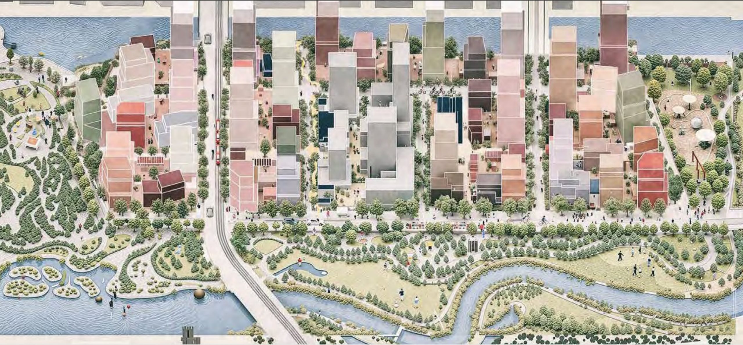
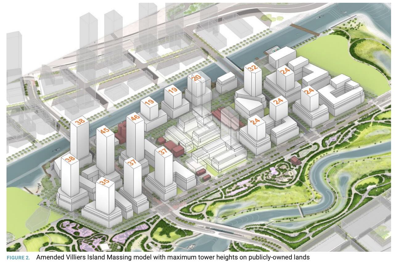
In several important ways, this plan is an improvement, featuring a much more granular approach to the development of a 21-acre island using smaller blocks, some riffs on public space (about which more in a moment) and a far greater variety of envisioned building sizes and forms, described in the proposal as “strategic density.” Per the bird’s eye renderings, the result is — or will be, or may be — a city scape that aspires to urbanism instead of ROI.
But I must confess I don’t love the new concept plan, and found myself wondering about the long-term viability of the ideas and symbolism it extolls — all the gestures towards Indigenization and the car-free high street (“commons”), as well as an idea of density that evokes those sections of mid-town Manhattan where buildings of all vintages, heights and purposes are crammed atmospherically together (and which took generations to achieve).
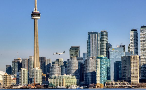
To my eye, the existential planning challenge confronting Ookwemin Minising is very obvious and external to the site itself: how does this island avoid becoming another Liberty Village, a precinct encumbered by a huge amount of density that is isolated from transit and cut off from the west end by transportation infrastructure? In fact, there are two other analogous development zones that should offer Toronto planners some cautionary lessons: the aforementioned South Core and City Place, between the Rogers Centre and Bathurst Street.
WT’s long-term and successful planning outlook has been to invest heavily in creating enticing public spaces — parks, boardwalks, etc. — that will, in turn, attract developers eager to build near such amenities. Ookwemin is surrounded on two sides — to the west and the south — with some of the most spectacular public spaces this city has ever created, i.e., Biidaasige Park, and the lower Don, as well the new park at the mouth of the Keating channel.
These spaces are necessary to attract development there, but they are not sufficient, and the reason has to do with transit. Yes, there are some bus loops through the port lands. Yes, some of the political blockage around the Waterfront East LRT loosened earlier this year with a big funding announcement. But that LRT project is years and years from completion, and, so far, we’re only talking about one part of the proposed streetcar service into Ookwemin.
Assuming the city and WT aren’t willing to wait for a decade-plus to tender the early development parcels, it seems highly likely to me that many of the first projects will offer plenty of parking to attract buyers/tenants who own cars they’ll need for crazy errands, like grocery shopping (how much density is required on Ookwemin to justify a supermarket?) or dropping kids off at school. Absent streetcars, we’ll be baking in car use, as well as bottlenecks near the two signature bridges, described in the new concept plan as “special moments.” Incidentally, the bottleneck story plays out twice daily at the spot where Liberty Village opens onto Strachan.
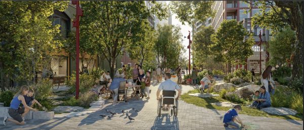
I also find that two of the most public-facing elements — the Centre Street Commons and Ookwemin Street, which are all or mainly pedestrian-oriented — to be performative, fodder for colour-saturated renderings and gullible city councillors, but by no means durable or even compelling.
More than most places with troubled settler narratives, Toronto has made significant strides in Indigenizing and decolonizing, which is as it should be. Indeed, I’d argue that the high-water mark of this work is the re-naturalization of the lower Don — a profound and historic gesture towards reconnecting the city with its pre-settler past.
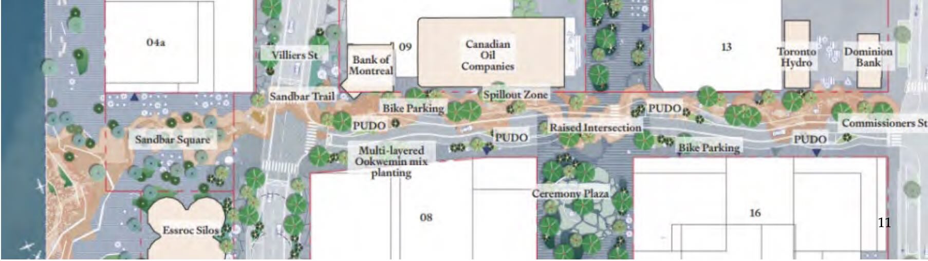
Next to that, Ookwemin Street — which uses meandering paver markings and trees to evoke an historic Indigenous path to the sandbars that became the Toronto Islands — feels gimmicky, and not especially resilient. We all know the type of public space neglect the City of Toronto is capable of, and I don’t think it’s overly cynical to predict that this “trail” will go the way of a lot of these kinds of high-concept landscaping gestures — torn up by roadwork, sloppily re-paved, littered upon, etc., etc.
Likewise the lushly landscaped Centre Street Commons, which is intended to somehow attract a spine of development, but without a civic focal point that will serve as an anchor and a magnet. Absent buildings, the Commons is just a street without a street wall. So the question is, does this particular expression of public space interest developers? It may be a lovely idea to have a car-free pedestrian street running through a fully built-out Ookwemin, but I’m not convinced this particular proposal is grand enough to entice builders to invest in a highly challenging area.
Finally, the projected walking times in the plan seem hugely optimistic, maybe clocking the pace of someone who is young and/or moves very quickly. Ookwemin’s south-east blocks, which will be developed last, are as far from the earliest phases, as well as proposed public spaces like Sandbar Square, as Church Street is from University Avenue. Not super far, but not close either, especially in a setting that will remain raw for years to come.
Sandbar Square — which is to overlook the Keating Channel, eventually facing a wall of tall towers, with another wall of tall towers at its back — to me exemplifies an unresolved tension at the core of this plan. Is Ookwemin supposed to be a piece of fully realized city, with all the trimmings, or does it aspire (at least via the design team’s ideas) to concoct some kind of naturalized, Indigenized slice of Manhattan or King West? Will the developers who build here buy in? And will the people who go to live there embrace these ideas as they go about the ordinary tasks of big city living?
Initially, those first residents will be, well, pioneers, colonizing, dare I say, this new-old piece of Toronto, and whatever form of urbanism takes root there. But if we want the future residents of Ookwemin Minising to live according to a vision of low-carbon urbanism, the city’s got to do the tough quotidian work of providing sufficient transit to ensure this precinct gestates and then functions without importing a glut of cars.
Whether the new concept plan gets us there, or even to the starting line, is an open question.
5 comments
Thanks you John for generating this great word of caution. As I was reading this I was reminded of my own neighbourhood – Corktown, which has all the physical elements of what makes for a great streetscape, which it definitely succeeds at BUT however the retail struggles, still lots of empty retail 11 years after the PanAm games and the a third of the trees dedicated to each country of the Americas that line Front St. E, are sticks or stumps and no sign of the City looking to replace or regenerate. SIGH!
The most vibrant “centre” is in fact the Cooper Koo YMCA, named after developer Michael Copper and his partner Krystal Koo. HAving been on the Board of the Y when this project was put in place, this makes for the case for greater multi sector partnerships in developing and designing our neighbourhoods.
Leslie
PS I could have sent this to you directly in an email but heck, the folks at Spacing should appreciate the great journalism that you undertake everyday and how important you are to the public discourse
Completely agree – I understand the need for more housing and I get that in Toronto, this has typically meant super high density in the places that we can fit it. But to me, there is a missed opportunity to create a truly liveable neighbourhood here. It might sound radical, but what if we imagined Ookwemin Minising with slightly fewer residents, living in predominantly 6-8 story buildings, with courtyards, ground floor commercial space, smaller streets etc. Despite the nice renderings filled with trees (though extremely out of proportion people and cars..) it’s looks like any other neighbourhood filled with towers. We all know how dehumanising those kinds of places feel. Despite the intentional design to create pedestrian only streets, that street is almost consistently going to be in the shade of 30+ storey towers. I’m a transplant from Toronto but I’ve lived in Berlin for nearly 7 years and while it’s by no means a perfect city, there is consistent density across most of it – with 6 storey buildings placed in large blocks with interior green courtyards. It feels like a more ‘human-scale’ city. When you can sit on a balcony on the sixth floor and still see and hear the street, or look into the trees growing in front of the building there’s a connection to your surroundings that doesn’t exist when you’re living 23 floors up.
I know there are many reasons for building such a neighbourhood in the way they’re proposing, the top one being economic of course…but for me it would be nice to see something that doesn’t look the same as everything else.
I really like Leslie’s and James’ thoughts – lower midrise to ‘see and hear the street…’ And thank you, John Lorinc, for a great article. This: ‘a city scape that aspires to urbanism instead of ROI…’ ‘Absent streetcars, we’ll be baking in car use…’ Toronto had lots of money at the same time cars were becoming the hot thing.
I personally don’t feel some of the public commons approach is too gimmicky – I do believe some meaning is meant to had here. I love the notion of this area growing as slowly and mindfully as it can and getting the grit and layers of great urbanism.
We know how to do this, we just need to do it. It is not a zero sum game. Toronto has some growing up to do and this seems like a better step forward to good vibes.
A key that Toronto city-builders could come to embrace is how can we build belonging while we build housing. Social infrastructure should be carefully considered especially in light of the many challenges the author points to. More than the infrastructure, the relational layer of how we connect new residents to what’s there for them and to one another like neighbours, is how we build the new districts where a feeling of pride, connection and belonging is possible. May it be great! Toronto deserves this exceptional place crowned with the Park.
Thank you for the great article John, the concerns you raised about the realities of how people actually populate neighborhoods, and how the City maintains – or rather doesn’t – the landscaping that architects dream up is very relevant.
The City’s 2024 plan was rightfully mocked, and the update is better in a great many ways, although the fact the first plan was ever released is concerning, and an indictment of our culture of planning and urban design.
From a transportation standpoint, the Waterfront East LRT represents multiple failures. As a concept, it draws only on Toronto’s past failed experiments with high-density waterfront transit, ignoring domestic and international examples that perform wildly better than our crawling streetcars, which even with supposedly incoming signal upgrades and operational reforms, will never match the speed or capacity or genuine grade-separated rapid transit. No matter how many pleasant streetscape photos are taken on Queens Quay West, the reality is transit is the slowest mode of transportation in the neighborhood, and the rate of private vehicle utilization reflects that.
For all the blatant nods to Canary Wharf and Lower Manhattan in the new plans design language, our terminally underperforming public servants have forgotten the keystone that allows these neighborhoods to function: genuinely fast and reliable metro service. In the Canary Wharf, this is delivered via the largely elevated DLR, and in Manhattan via the famous tunneled trunk lines of the New York City subway network. These lines make the streetcars look like the toy trains they are, operating at median speeds of 30km/hr, while our *best* streetcar lines are lucky to average 15km/hr. As a result, transit utilization will be low, and traffic will be even worse than in Liberty as downtown-bound east-end traffic tries to cut through the neighborhood. Do we need to build a mirror copy of either one of these examples to serve the area? No, of course not, but continuing our delusional obsession with streetcars is the worst of all possible options.
This neighborhood is a disaster in-wait that has been “planned” every step of the way.