The process of urban planning has always been a bit of a mystery to me and I don’t believe I am the only one to feel this way. The technical practice of contemporary urban planning tends to still be largely inaccessible to those not trained and directly involved in the process. This of course creates a gap in understanding between community members or clients and the urban planner.
It is this gap that the members of elementslab, an applied research group situated at the University of British Columbia within the School of Architecture and Landscape Architecture and the Centre for Interactive Research in Sustainability, are seeking to bridge through their research and development of spatial decision support tools and approaches for urban design projects and municipal planning. It is precisely through these tools, which they shared with me, that I got the chance to better understand the urban planning process – just a small example among many others that this research group is heading in the right direction towards greater accessibility in urban planning. By creating approaches that allow community members and clients to engage in the same technical processes, they may even open up the way for collaboration in which both parties can mutually inform one another.
The principal tool of elementslab is elementsdb, a database of systematized urban form case studies, or “elements”. Each of these elements shows a carefully measured, illustrated, and modeled study of an existing urban buildings or space and includes data about it—such as its density, environmental performance, and land use coverage. The database holds a variety of urban space examples including residential, commercial, civic, and industrial buildings, open spaces, streets, and parks. As staff member Mike van der Laan explained to me, the standardization of these elements is key to providing accurate visuals of typical neighborhood land uses. Most importantly, it allows for comparison across cases that has opened up the development of tools which can use the data to visualize potential urban plans, predict certain outcomes of these plans, and allow a comparison between the potential proposals.
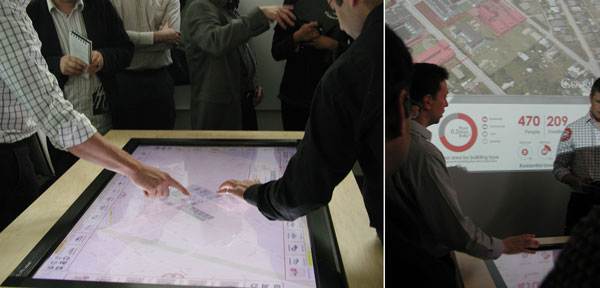
A recent and promising tool created by elementslab is a collaboration ‘touch table’. It is composed of a television set mounted flat onto a table built from plywood, attached by double-sided tape, and of course, linked to multiple communication softwares. What this does is allow the database “elements” to be digitally inserted onto a map, plan, or aerial photograph of a site as a means of exploring a potential urban plan.
The user simply drags the image of a selected case, for example a high-rise residential building, from a sidebar on the screen onto the digital map and looks at what the numbers say. The user can then replace the high-rise with another case, say a set of row-houses, and compare the difference in the predicted data. Co-founder Ronald Kellett refers to this kind of experimental process as “playing in a digital sandbox”.
While the sandbox metaphor may lighten the real complexity of the urban planning process, it effectively explains at least some aspects of the elementsdb database and touchable technology. A sandbox allows for play and experimentation in three-dimensions. The same holds true for research tools. As Ron explained, thanks to the database we can now “talk about density or land use and show pictures of them and can literally put them together in spatial ways and get some sort of picture and sense” which he believes will help bridge the gap between “academic endeavors and the needs of cities and societies, at large.”
Furthermore, similar to a sandbox where a variety of forms can be built and unbuilt without any additional resources, the same is possible with the database and technologies like the touchable. When once it was common for an urban planner to work thoroughly on only a few proposals, now multiple versions can be explored with less effort, in less time, without any extra resources, and not necessarily just by an urban planner.
elementslab and School of Community and Regional Planning faculty member, Maged Senbel also referred to play-building and experimentation by using lego blocks as a metaphor for explaining how this kind of urban planning process works. He characterized it as “creating building blocks that can be collaboratively assembled” in which “the building blocks are not necessarily buildings but they’re building blocks of a neighborhood with increasing sophistication in these blocks”. These building blocks (the urban elements) function like legos, which he characterizes as the simplest form, in that they’re manipulable and anyone can build with them. However, they carry a lot more information and will provide a record of what their placement means in terms of measurements and predicted data such as environmental impact, building use diversity, connectivity, and density.
Simply put, elementslab offers an accessible tool for urban planning play and experimentation that comes with a lot of sophisticated data and information. And they have put this play into practice. In a workshop with residents of Revelstoke, a small city in British Columbia, elementslab asked participants to use the database and touch table to design their own plans for the site in consideration. In their plans the participants were required to “achieve” a set of goals regarding the number of dwellings, emissions, and transportation. Threshold circles were programmed that showed whether the participants were below or above the desired numbers based on the data computed from their choice of elements.
In this exercise, the members of elementslab intentionally did not want one outcome. Indeed, the results were varied with community members showing different opinions regarding how much commercial space and how much density was acceptable. There was also a contrast between those that chose a diversity of building types and those that stuck to more homogenous plans.
Afterwards, elementslab graphed the various points and plans and overlaid them on top of each other to look for patterns. This exercise not only allowed for the public to better understand the work of the urban design process, but also created an opportunity for the public to inform the designers. Through the use of the database and touchable, both parties were able to communicate with the same technical, visual language, thus leading to better understanding between them.
elementslab hopes to continue this kind of exploratory research and to expand the number of cases in the database. As of now the selection of the elements in the database is largely dependent on resources made available to the lab – mainly through working with cities or through small grants. The staff members also often choose elements for specific cases because they either function as ‘typical’ urban forms or because they may perform particularly well to fulfill a specific requirement. For example, if there is a requirement to achieve a certain density, different multi-unit building types may be chosen to provide numerous options to achieve that density.
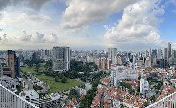
While the database holds elements from various Canadian cities, the lab predominantly focuses the West Coast and Vancouver and more specifically what they consider one of Vancouver’s greatest urban challenges – “fitting density to transportation investments”. Despite this focus, they do not limit themselves to site-specificity and often experiment, or “hack” as Ron calls it, by inserting elements from other cities into Vancouver site plans. Whether or not one perceives this as promising or problematic, it’s clear that if the database continues to grow it will open up the opportunity for many more diverse Canadian cases that can be mixed and ‘hacked’ and provide an exploration of what may or may not work in future plans.
In addition to continuously increasing the number of database cases, elementlab’s next focus is on how the small scale studies they have been doing can be applied to larger scales and how the data can be used to predict a longer period of time as development continues to grow. For now, they are using ESRI’s geospatial modeling software “CityEngine” that uses parametric rules to create codes that will replicate the smaller scale plans onto a larger scale. This work is based on the assumption that cities are made up of replicable land and building types that serve as a framework that is then “fine-tuned” through other design, social, political, and economic processes. However, the members of elementslab emphasized that their tools provide a much more fine-tuned framework because of the information that backs it up.
Despite their overall optimism, the staff at elementslab also stressed that the functionality of these approaches is still limited and that the process is still at the development stage. As co-founder Ron put it, “we’re rehearsing potential futures… they’re sandboxes we’re just playing in, simulating situations, creating potential… we can only do some things, there are many interesting questions about designing cities and we can only ask some of them”. These are important limitations to keep in mind. However, it’s hard not to feel hopeful about elementslab’s potential to answer many questions non-urban designers may have.
Based on how much I learned by playing in the sandbox, as well as by the community engagement such as in the Revelstoke workshop, it is clear that one of the most promising aspects is the program’s ability to, as Maged eloquently put it, “revolutionize spatial education” and to “empower non-designers and members of the public to participate in design processes that have been previously unavailable to them”.
***
Check out the elementsdb database.
**
Natalia Zdaniuk is a recent graduate of architecture and human geography at the University of Toronto. She is currently living in Vancouver and enjoying learning about the city.


