To understand contemporary Singapore, we have to understand key aspects of its history—divided here into “Four Acts.” This will be our starting point: introducing themes and issues that we will elaborate on in future pieces.
Act I: Before the Grid
Before the skylines, before the zoning codes, before the island was a node in global finance, there was another Singapore. For at least 700 years, long before British colonization, the island now known as Singapore was part of a shifting regional maritime world—marked not by land ownership, but by fluidity, trade, and cosmopolitan entanglement.
Archaeological findings and historical texts suggest that by the 14th century, Singapore—then known as Temasek—was already a significant regional port. Chinese records refer to it as Danmaxi, a place of exchange and strategic anchorage. Located at the crossroads of the monsoon winds, Temasek attracted Malay, Javanese, Indian, Arab, and Chinese traders. It was neither a nation-state nor a city in the modern sense, but a layered settlement shaped by tides, barter, and regional power struggles. Temasek’s links extended beyond Southeast Asia into the Indian Ocean and South China Sea networks, forming part of early global maritime circuits.
Among its earliest inhabitants were the Orang Laut, the “sea people,” who maintained networks across the Riau archipelago and played crucial roles as navigators, guardians of sea routes, and allies to regional sultanates. These communities lived in a way that was deeply connected to the sea—where movement, seasonal rhythms, and interdependence with water defined territory and belonging.
The rise of the Malay world in the 14th and 15th centuries saw Singapore’s fate tied to empires like Srivijaya and Melaka, and later to the Johor Sultanate. The island functioned as an outpost, a fortified location, and occasionally a contested prize between rival cultures. Its meaning was relational—dependent on broader regional ecologies and geopolitics, rather than any intrinsic fixed identity.
This pre-colonial past matters deeply. It unsettles the narrative that Singapore’s story began in 1819 with Stamford Raffles and reminds us that spatial organization in this region long predated modern planning. It also points to other forms of governance, connectivity, and cultural pluralism that were not based on bureaucratic control, but on negotiation, mobility, and ecological intimacy.
In recovering these histories, we also encounter silences. The Orang Laut, like many indigenous or non-state actors, were gradually marginalized—not only materially, but in the stories Singapore tells about itself. As the island transformed into a modern city-state, many of these earlier lifeways were erased or relegated to folklore.
Yet they leave traces: in place names, in maritime customs, in the margins of planning maps. To understand Singapore’s planning culture today, we must begin with what came before the grid.
Act II: The Colonial City – Order and Segregation
The arrival of Stamford Raffles in 1819 marks the formal entry of Singapore into British colonial rule, but it’s better understood as a turning point rather than a beginning. Raffles, drawing from the Enlightenment ideals of rational order and free trade, laid the foundations of a colonial port city that would serve British imperial interests in Southeast Asia.
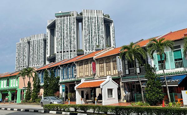
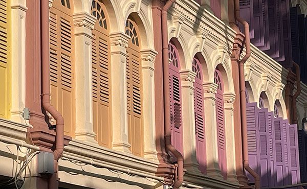
The 1822 Jackson Plan, commissioned by Raffles, was Singapore’s first urban blueprint. It imposed a layout based on separating races: a European Town, a Chinese quarter, a Malay-Muslim enclave, and a zone for Indians and “others.” Remarkably, key elements of this racialized spatial order remain embedded in Singapore’s urban fabric today. Districts like Chinatown, Little India, and Kampong Gelam continue to function as ethnic and cultural nodes, reflecting their original colonial designations.
These zones have been preserved not just as heritage sites, but also as living urban environments with strong cultural branding and community identity. This racialized urban form mirrored colonial ideologies of governance—order through separation, hierarchy through space.
Singapore’s transformation into a mercantile port accelerated with the growth of entrepôt trade. As a designated free port under British rule, Singapore attracted merchants from across Asia and beyond, offering tax-free trade that amplified its appeal as a regional hub. This status helped consolidate its role as a key node in British imperial logistics and contributed significantly to its rapid urban and economic development.
By the late 19th century, dockyards, godowns, and shophouses formed the backbone of a bustling economy. Yet infrastructure for the majority—particularly sanitation, housing, and public health—remained underdeveloped.
Kampongs (villages) and overcrowded tenements were common, especially among the working-class Chinese and Indian labourers. While most kampongs were cleared in the decades following independence, a few still persist on the city’s edges. Notably, Kampong Lorong Buangkok remains Singapore’s last traditional village on the mainland—a living anomaly in a landscape dominated by high-rises.
On Pulau Ubin—a place we will look at in more detail later in the series—kampong life endures more visibly, though it is slowly being erased through attrition and soft redevelopment pressures. These remnants serve as poignant reminders of the lifeways and the layout of the city’s displaced in the city’s march toward modernity.
Colonial urbanism, then, was a project of selective modernity. Roads, railways, and civic buildings reinforced imperial authority, while spatial segregation naturalized social divisions. Planning was less about inclusivity than about control…of bodies, capital, and space. The establishment of early municipal systems, particularly around water supply and waste disposal, exemplified how selective infrastructural investments were used to maintain order and hygiene within elite enclaves.
However, this period also saw the emergence of urban pluralism. Yet, the racial divisions enshrined by the Jackson Plan also find echoes in contemporary urban form—not just at the district scale, but also within the public housing system. Ethnic percentages implemented in Housing Development Board (HDB) estates ensure a balanced demographic mix, but also reveal how the logic of spatial differentiation continues in modified form, embedded within the built environment and everyday life.
Religious institutions, community organizations, and ethnic enclaves flourished in parallel. The strict layout rules of the Jackson Plan were never fully realized, and lived experience often defied formal zoning. These contradictions would set the stage for future debates around national identity and multiculturalism.
Act III: Post-Independence – Nation-Building through Planning
The Housing and Development Board (HDB), created in 1960, became the nucleus of Singapore’s public housing revolution. The early decades of this program required the displacement of hundreds of thousands of residents from kampongs and informal settlements. Entire communities were resettled—sometimes rapidly and without full consultation—as part of a broader land optimization strategy.
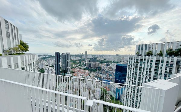
This principle of land optimization underpins much of Singapore’s planning ethos, where land is treated as a scarce and finite national asset to be rigorously managed. The outcome of this strategy is a city dominated by high-rise residential towers, a vertical urbanism that reflects both physical constraint and ideological vision.
Replacing the older Singapore Improvement Trust, HDB was tasked with clearing slums and resettling thousands into modern, high-rise flats. Through its work, HDB displaced kampong dwellers into high-rise flats and structured social life to support state goals. It implemented ethnic integration policies, developed Community Care Apartments for seniors, and encouraged intergenerational proximity through housing grants.
These strategies were tied closely to centralized land acquisition, made possible through the 1966 Land Acquisition Act, and financed via individual Central Provident Fund (CPF) savings—an initiative that we will look at more closely later in the series.
Architecturally, HDB flats were modular and standardized, ensuring rapid delivery and visual coherence. Yet its mission extended beyond housing provision—it became a mechanism for social engineering, integrating ethnic groups across estates and fostering a sense of national identity.
Each town was planned as a self-sufficient unit with markets, clinics, schools, and community spaces. Over time, HDB evolved from a provider of basic shelter to a designer of increasingly sophisticated, attractive, and integrated living environments, including the recent “Designing for Life” vision.
The Urban Redevelopment Authority (URA) took charge of city centre renewal and long-term land use planning, translating national imperatives into spatial form. It oversees the Concept and Master Plans that guide Singapore’s land use, ensuring alignment between national policy goals and spatial realities.
The URA also coordinates closely with HDB to determine zoning, plot ratios, and strategic infrastructure investments. The 1971 Concept Plan and its successors introduced a framework of decentralization, transport integration, and strategic land banking. Industrial development, notably in Jurong, exemplified this alignment between spatial planning and economic strategy.
Other key agencies also played significant roles. The Land Transport Authority (LTA), formed in 1995, was charged with developing an integrated transport system. It worked alongside URA to shape land use around Mass Rapid Transit (MRT) stations and major road corridors, enabling a transit-oriented development model.
Meanwhile, the Health Promotion Board (HPB), established in 2001, brought public health into the urban planning conversation, particularly through initiatives encouraging active lifestyles, ageing-in-place, and wellness design.
The National Parks Board (NParks) also became increasingly central, spearheading the greening of the city through initiatives like the Park Connector Network, urban biodiversity planning, and the “City in Nature” vision, integrating ecological resilience into the fabric of urban development.
Together, these agencies—HDB, URA, LTA, HPB, and NParks—created a coordinated ecosystem of planning, supported by a structured three-tiered planning framework: the long-term Concept Plan, the statutory Master Plan revised every five years, and detailed Development Plans with regulatory controls such as streetblock plans and urban design guidelines. URA plays a central coordinating role in aligning these plans across agencies and resolving cross-sectoral conflicts.
Planning in this era was unapologetically top-down, but it delivered.
One of the clearest examples of this coordination was the post-independence push to decentralize Singapore’s urban core. The 1971 Concept Plan envisioned a constellation of regional centres—such as Tampines, Jurong East, and Woodlands—intended to ease congestion in the central business district while bringing jobs, amenities, and housing closer to residents.
This move was supported by a robust Mass Rapid Transit (MRT) network and strategic expressways, designed and implemented by LTA, that made commuting between towns seamless. These transit corridors were not just infrastructural—they were planning tools that shaped land value, housing densities, and commercial siting.
In each case, agencies coordinated across plans: URA designated regional growth nodes, HDB populated them with housing and social infrastructure, and LTA ensured connectivity. The Healthy Promotion Board (HPB), while a later addition, began aligning these plans with public health strategies—encouraging walkability, elder-friendly design, and accessible wellness facilities.
Together, these efforts helped shape the modern polycentric Singapore, reducing reliance on the historic downtown while ensuring that growth remained equitable, strategic, and infrastructurally supported.
Act IV: The Contemporary Turn – From Control to Complexity
Another defining layer of Singapore’s spatial culture is its highly curated food and commercial infrastructure. The modern hawker centre system evolved from the government’s effort to relocate unregulated street hawkers into clean, organized environments. These centres now serve not only as vital public eating spaces but as expressions of multicultural identity and everyday social life.
Parallel to this is the emergence of a mall culture that permeates the cityscape. Malls are not only retail hubs but also air-conditioned public spheres—connecting to MRT stations and linked via vast underground pedestrian networks. These subterranean passages stretch for blocks, enabling seamless mobility sheltered from tropical heat and monsoon rains. The centrality of air conditioning in this landscape cannot be overstated—it is an infrastructural condition that shapes architectural form, commercial life, bodily experience in the city, and energy demands.
While Singapore is often portrayed as a city governed by top-down control and consensus-driven planning, it also harbours currents of dissent and alternative expression, particularly in its artistic and cultural scenes. As SFU’s Joanne Leow notes in her book Counter-cartographies, Singaporean artists, writers, and performers have long challenged official narratives, offering layered and sometimes subversive readings of space, identity, and history. These cultural interventions reclaim public discourse and complicate the image of a city wholly shaped by the state.
From performance art that critiques surveillance and censorship to literary works that reimagine erased landscapes, the arts in Singapore act as a quiet, persistent form of resistance. They constitute a parallel urbanism—one that sketches desire lines through a master-planned city, revealing the emotional and political geographies that lie just beneath the polished surface.
Since the 1990s, Singapore has gradually shifted from a paradigm of pure control to one of calibrated complexity. The planning apparatus still retains central authority, but it now incorporates new values: sustainability, liveability, wellness, and cultural vibrancy.
Initiatives like the LUSH program (Landscaping for Urban Spaces and High-rises), the City in a Garden vision, and the Singapore Green Plan 2030 illustrate this pivot. Conservation efforts have expanded, with heritage districts like Chinatown and Kampong Gelam integrated into urban branding and tourism.
At the same time, the government has embraced digital governance and data analytics to optimize everything from mobility to housing allocation, particularly in the context of urban planning and design. The Smart Nation initiative, for instance, leverages sensors, citizen feedback, and predictive modelling to enhance urban efficiency—but also raises questions about surveillance and the use of computer programs and data to help make decisions.
Tools such as the LTA’s OneMap geospatial platform exemplify this approach—embedding real-time data into the policymaking and design process to maximize efficiency, adaptability, and transparency. Singapore is also at the forefront of creating a digital twin of the city as a means of testing future transformations, as well as monitoring and maintaining infrastructural systems.
Importantly, planning has begun to grapple with social well-being. The idea of a “Healthy City” now intersects with transport design, green spaces, and ageing policy. Yet, tensions remain: between inclusivity and market logic, between heritage and development, and between soft governance and lived resistance.
Singapore’s planning story is still unfolding. It remains a city of intention—where every street, every void deck, and every skyline decision carries a deeper logic of survival, ambition, and identity. But the question is no longer just how to plan the city. It is how to live—and thrive—within it.
The next chapter in our journey will turn to conservation: how heritage is curated, contested, and reimagined in a city that often seems obsessed with the future.
***
All pieces in The Singapore Chronicles:
- Part 1 – Introduction: The Paradoxical City
- Part 2 – Singapore’s Urban History in Four Acts
- Part 3 – The Politics of Preservation
- Part 4 – Housing the Nation
- Part 5 – Memory in the Margins
- Part 6 – Designing for Urban Health
- Part 7 – Conclusion
- Part 8 – Divergent Models: Singapore, Barcelona, Vancouver
***
Erick Villagomez is the Editor-in-Chief at Spacing Vancouver and teaches at UBC’s School of Community and Regional Planning. He is also the author of The Laws of Settlements: 54 Laws Underlying Settlements Across Scale and Culture.