
Walk through a neighbourhood with someone who grew up there, and the stories start. The diner that used to be on that corner. The whole block that looked completely different. There is nostalgia in it, something close to loss, even when what is being mourned is a supermarket surrounded by a parking lot. The city changed; it is not the city they grew up in. The gap between what a place was and what it became is the past as most people carry it: personal, and real.
The physical city offers something different: what was actually built, what still stands, what was demolished. It is the least contestable version. Reading it is less like studying history and more like archaeology.
Reading the Physical City
A building either stood here, or it did not. A street was once narrower, or it was not. A shopfront changed, or it did not. These facts precede any story told about them. They do not shift depending on who is asking. The interpretation comes after. The evidence is prior.
Yet the way we naturally engage with the past is through narrative. Not history as a discipline but something more instinctive. The stories that tell us who we are and where we belong. A neighbourhood’s past gets filtered through identity, through group memory, through which communities have been present and which have been erased. The big moments get told: conquest, displacement, struggle, transformation. The mundane goes unrecorded. The everyday business of how people moved through a place, what they bought and sold, which corner they gathered on, rarely survives the passage into story.
Physical evidence cannot tell you what someone was thinking or feeling. It cannot capture the emotional texture of a place. It can show whether a building was there, what shape it was, where the lot lines fell. Sometimes, when everything around a single structure has changed, that one surviving building becomes the hook between past and present. Overlay a photograph from fifty years ago on what stands today. Trace one image onto the other. The difference between them is the time that passed.
Lines on the Map
Some of the most persistent things in a city are invisible. Not the buildings, not the streets, but the lines. The cadastre: the official record of property boundaries, ownership, and subdivision drawn at a specific moment in time. A cadastral line defines who owns what, where one lot ends, and the next begins, which land is private and which is public. Buildings come down. The cadastral line remains.
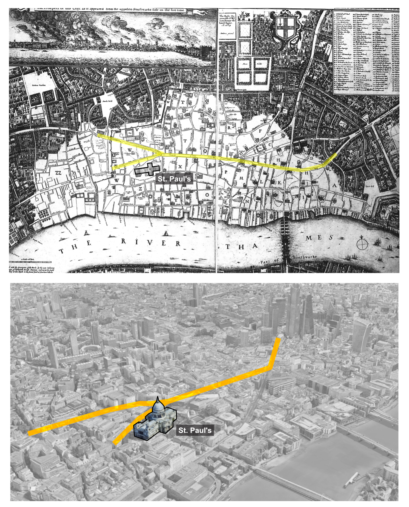
In 1666, the Great Fire of London destroyed most of the medieval city. A survey map made in the immediate aftermath shows the burned area in white, the surviving buildings in black. The destruction was almost total. Yet overlay that map on what stands today and some of the street pattern is still recognizable. The split at St Paul’s. The main trajectories. The fire burned the buildings. The land was still owned. The road was still public. The new buildings were rebuilt within the existing lines.
In 1755, the earthquake and fire that destroyed central Lisbon gave the Marquis of Pombal the choice to start again. The old cadastre was set aside, and a new rectilinear centre imposed: the Baixa Pombalina, symmetrical, ordered, with the Praça do Comércio at its end. The lines were redrawn by political authority. That grid stands today. London rebuilt within its cadastre. Lisbon redrew it. Both cities still carry the decision.
Catastrophe is the most visible version of this, but the same logic plays out in any change a city goes through. Industrial land is especially revealing, shaped by its own geometry: the turning radius of a train, the spur lines feeding a factory.
What the Rails Left
In Vancouver, a CPR rail line once ran diagonally from the port through Gastown and Chinatown to the False Creek yards, cutting across the rectilinear street grid at an angle. The line stopped carrying trains in 1931, its trace remaining in the cut-off corners of old buildings along the route, in triangular gaps that resisted straightforward development, in lot lines that no subsequent subdivision fully resolved.
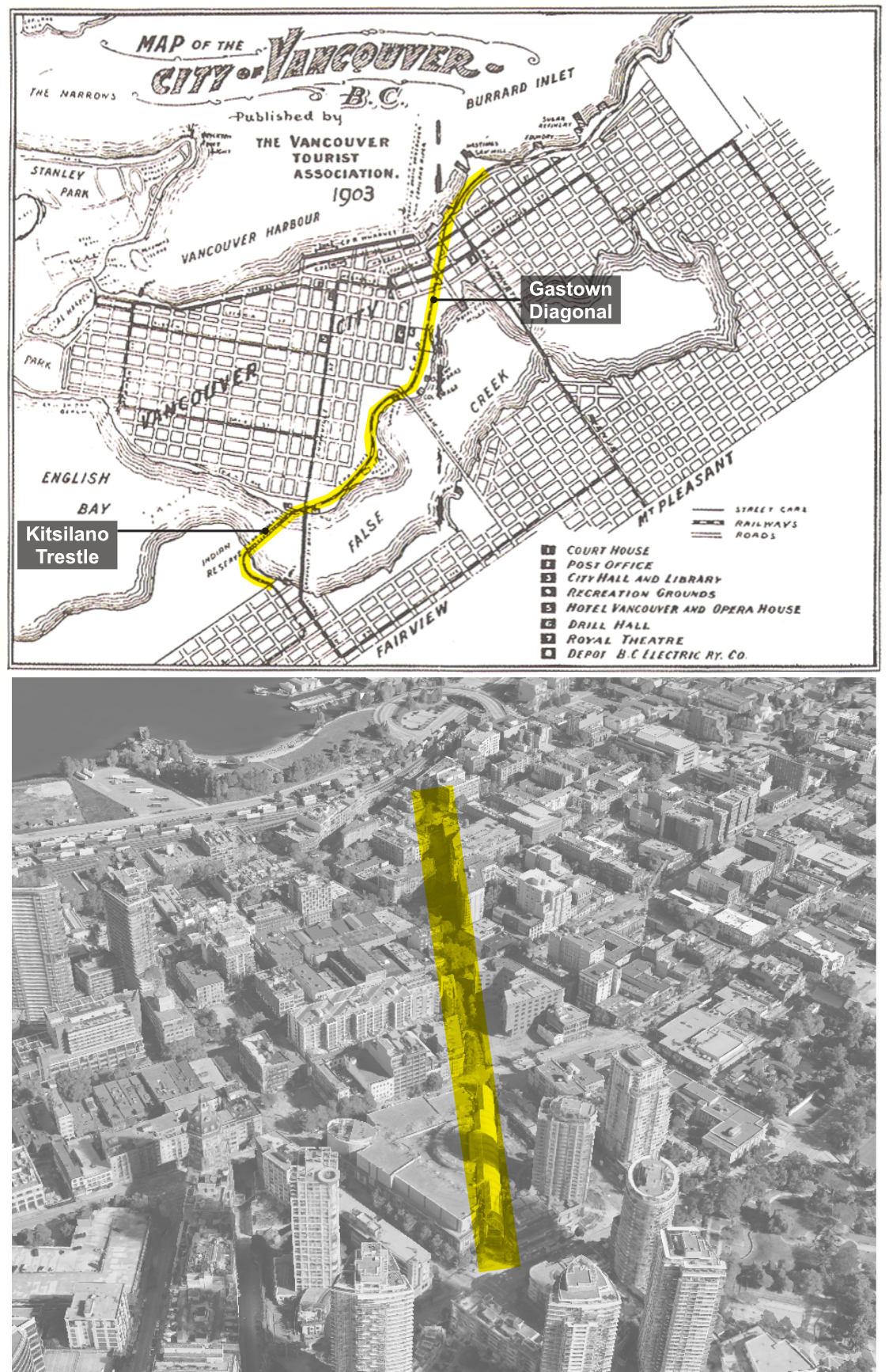
That same rail network continued west through the False Creek yards, where the Roundhouse community centre still marks the CPR’s former train-servicing hub, and across the Kitsilano Trestle, which spanned False Creek just east of the Burrard Bridge until its demolition in 1982.
Just south of where the trestle once landed, the Squamish Nation land that forms the Sénaḵw development site follows the same geometry. The land was returned to the Squamish Nation after the rail use ended. The 1903 map (above) of Vancouver labels it simply as “Indian Reserve.” For forty years after the trestle came down, it sat largely outside the city’s development ambitions. Now it is under construction: thousands of homes on a triangular strip whose shape was drawn by a rail corridor laid in the 1880s.
The Documented Near Past
The near past is still up for interpretation: what changed recently is still fresh, not yet history.
Access to the near past has never been more immediate. Not through official archives alone, but through crowdsourced documentation: maps anyone can update, photographs anyone can contribute, and the accumulated posts of social media, communities sharing images of places.
Mapping services that enable street-level navigation through imagery are regularly updated. That upkeep has produced, as a byproduct, a valuable year-by-year record of how the city changes. Incrementally, at a fine enough grain to see one shopfront replace another, one building renovated, one corner altered.
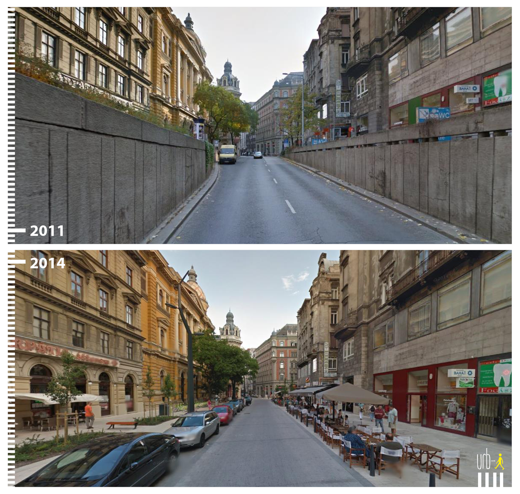
In 2015, I conceived the Urb-i Before|After project, using five or six years of available street-level imagery to document public space transformations across cities worldwide. Streets that had shifted from car-dominated to pedestrian-friendly, captured in pairs of photographs taken years apart. The project grew into a crowdsourced archive of thousands of examples, circulating on every continent. At that scale, a before and an after was the story. A decade later, the same approach applied to ten or twenty years of imagery reveals something different: not two endpoints, but the process between them.
As explored in Time and the City, cities change at different timescales. At five or ten years, the incremental drift becomes legible.
Trace an image of a street from ten years ago onto what exists today and what changed becomes visible in a single overlay. The curb line that moved as the street received a road diet. The buildings that appeared, or disappeared. A skyline seen from afar, buildings rising year after year until a new horizon has formed.
This is what the near past shows that the official record cannot: change as a process, not an event.
What Remains
The city holds its past in the ground. In the lot line that survived a fire. In the diagonal cut of a street that once followed a rail. In the triangular strip of land whose shape was drawn by a rail corridor that, over time, became obsolete. These are not only memories or stories. They are evidence, still present, still readable. More recently, a different kind of evidence has accumulated: the photographic record of streets, block by block, year by year. More stories are recoverable through increased documentation, though many remain untold. Where traces are no longer visible, the past is carried forward through memories, and the story is what remains.
***
<< The City in Tenses | The Pasts of the City | The City in the Present >> (next article in series is coming soon)
***
Yuval Fogelson is an urban designer, educator, and artist who loves to explore and understand cities. Based in Vancouver, his work spans the built environment, from public space transformations and tactical urbanism to mobility hub networks and digital twins. He is the founder of YF City Urbanism and paints maps as part of Yellow Future City.