
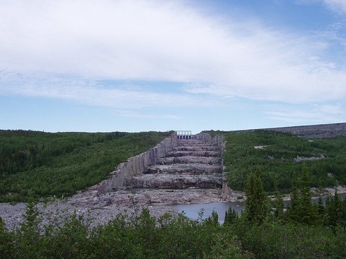
Les Escaliers des Géants: Spillway of the Robert Bourassa Hydroelectric Dam. Photo by Lily Pan, June 24th 2008. Used with permission.
1300 kilometers north of Montreal, I have reached the end of the road.
To the west, the town of Radisson perches below the Robert Bourassa (LG-2) hydroelectric complex, buzzing under a thick forest of electrical towers. To the east, towards James Bay, lies the infamously displaced Cree community of Chisasibi.
Montrealers have all, indreictly, had a hand shaping the landscape of this remote hinterland. Our city is connected to this place by a direct lifeline or, more precisely, by over 60,000 kms of aluminum powerlines.
The Robert Bourassa complex hosts 16 underground turbines that work day and night to produce the clean, relatively cheap electricity we consume in our city and beyond. Our reliance on hydroelectricity allows Quebec to stand so effortlessly in favor of the Kyoto Agreement and other climate change policies.
The darker side to Hydro development – displaced Cree commnities, major changes to the region’s hydrology and decades of mercury contamination in the fish – is, for most of us, a long-forgotten controversy.
But on-site, the extent to which we have altered the landscape to create hydropower in Quebec is astonishing, and undeniably impressive. Hydro Quebec’s tourist panels proudly describe the project, which began in the 1970s, as “audacious.” The magnitude of the project is hard to grasp even on-site as the entire La Grande complex covers over 100,000 square kilometers.

La Grande Complex map from Hydro Quebec
The Robert Bourassa dam is over 500 meters wide at its base and about as high as the Olympic Stadium. This structure can hold back the entire flow of La Grande Rivière, the second-largest river in Quebec (after the Saint-Lawrence). The Robert Bourassa reservoir stretches to the horizon, a flooded an area more than five times the island of Montreal.
The “giant stairs” of the reservoir’s spillway (a kind of emergency exit in case the reservoir were to overflow), are 1.5 km long and each step 10m high and wide as a city block.
Four other rivers (Caniapiscau, Eastmain, Opinaca and Petite Opinaca) have also been diverted to feed into the generators. The Rupert river will be the next to be dammed, with construction already underway. A large proportion of its water will be diverted 360 kms off its natural course into the Robert Bourassa reservoir.
Downstream, the Cree Nation of Waskagnish still has plenty of unanswered questions about how this will impact the local environment, their traditional hunting and fishing grounds, and their health.
More information about the La Grande hydroelectricity complex is available from Hydro Quebec:
More about the Cree community of Chisasibi on the Spacing Montreal tomorrow!
5 comments
I saw a movie a couple of years ago about a man who takes the corpse of his deceased father to this dam to burry it. I was amazed at the scale of the project. Since then I always wanted to go there but 1300 km is a bit far.
It was a good movie, though I can’t find its title right now.
Excellent post and stunning picture. I got thinking about this place when I read this question at Ask Metafilter a while back: “What is this huge line across Canada?” For some reason, just following the lines north through all that barren land gives me the willies. The scale of the whole system — the fact that it connects from up there to my apartment — is for me difficult to believe.
Wow-the scale of this scheme is incredible. Hope all the cheap gas and electricity is worth it.
Where’s the follow-up article?
Here’s the follow up article, which ended up coming out a few weeks later,
https://spacing.ca/montreal/2008/09/27/the-lost-village-of-fort-george/