Sources :
Le collège André Grasset, Jacques Bannon, Fides 2003 www.maps.live.com
Recommended for You
13 comments
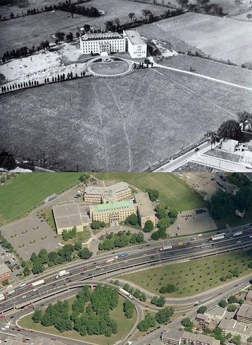
La courbe que le boulevard Métropolitain fait à cet endroit était précisément pour ne pas exproprier le collège.
Comparativement, le grand déplacement vers l’ouest que l’autoroute 15 fait à Laval entre l’autoroute 640 et la rivière des Mille-Îles a été fait pour pouvoir exproprier quelques terres de supporteurs de l’Union Nationale et éviter d’autres terres libérales.
Je me demandais pourquoi ce collège était aussi mal situé. ..
Man – there was so much room to build a real highway and not the two lane retardedness that they built.
Il y a 50 ans, il n’y avait même pas un dixième des autos qu’il y a présentement; le boulevard Métropolitain tel que construit suffisait amplement à la tâche.
Not far south and west of there, the grounds of St-Alphonse d’Youville were also destroyed by the bloody boulevard Métropolitain.
Where do all these fans of polluting, urban-tissue destroying private motor transport come from? A throwback to the 1950s?
I go there!!!
The school is very neat but everything is so wasted with the Met!!!
Everytime I finish my classes, it’s impossible to forget the met, so ugly!!!
By the way, in some pictures of 1939 or so in the school, it shows an annex with a clocktower on the West Side part of school, where now sits the gymnasium. Has anyone heard of it?
That part was never built, it was just a proposition.
The Met was inadequate upon completion. That is why they had to add an additional lane immediately. Moreover, the thinking at the time already acknowledged the need for room to expand, they choose not to do so to save money. The same goes for Decarie.
BTW – the highway supports and lets exist the “urban tissue” around it. Unless the high and mighty use magic for their food, clothes etc..
GDS don’t bother with them, density builds around highways, especially the MET… have you seen how many towers have popped around it?
Highways aren’t supposed to look good, they are not art, they are utilitarian infrastructures needed by far and large by this society, get over it people.
Highways are so 50s… yeah right, as if the solution to people and goods transportation has been solved by teleportation… it hasn’t, get used to them.
These people are just jealous cause they can’t walk or bike on the MET… ;-)
There are trains and trams you know. Nobody is talking about teleportation.
Here is a view from the STM collection showing the end of one era and the beginning of the next.
A MTC Tower Car is removing the trolley wire from the supports on the Millen Route private right of way behind houses on the East side of Rue Foucher at Cremazie, now at the Southern end of Parc St Alphonse.
To the left of the image is the Metropolitan under construction.
At this time the track was single at this location being used just to bring the streetcars back to Youville Shops for the night, the Southern-most station on the Millen route being located to the North at Ave. Emile Journault.
The LAST streetcar track actually constructed in Montreal was a single-track built to the West/Right of this image over to Youville Shops at St Laurent.
After the wire was down, the Tower Car went to Youville Shops and was burned with the streetcars that preceeded it.
They soon had company with the cars from Cartierville 17 in June/July 1959, then most of the cars from Papineau and Mount Royal routes in September after the last day of tramway operation in Montreal on August 30, 1959, soon to be 50 years ago.

13 comments
La courbe que le boulevard Métropolitain fait à cet endroit était précisément pour ne pas exproprier le collège.
Comparativement, le grand déplacement vers l’ouest que l’autoroute 15 fait à Laval entre l’autoroute 640 et la rivière des Mille-Îles a été fait pour pouvoir exproprier quelques terres de supporteurs de l’Union Nationale et éviter d’autres terres libérales.
Je me demandais pourquoi ce collège était aussi mal situé. ..
Man – there was so much room to build a real highway and not the two lane retardedness that they built.
Il y a 50 ans, il n’y avait même pas un dixième des autos qu’il y a présentement; le boulevard Métropolitain tel que construit suffisait amplement à la tâche.
Not far south and west of there, the grounds of St-Alphonse d’Youville were also destroyed by the bloody boulevard Métropolitain.
Where do all these fans of polluting, urban-tissue destroying private motor transport come from? A throwback to the 1950s?
I go there!!!
The school is very neat but everything is so wasted with the Met!!!
Everytime I finish my classes, it’s impossible to forget the met, so ugly!!!
By the way, in some pictures of 1939 or so in the school, it shows an annex with a clocktower on the West Side part of school, where now sits the gymnasium. Has anyone heard of it?
That part was never built, it was just a proposition.
The Met was inadequate upon completion. That is why they had to add an additional lane immediately. Moreover, the thinking at the time already acknowledged the need for room to expand, they choose not to do so to save money. The same goes for Decarie.
BTW – the highway supports and lets exist the “urban tissue” around it. Unless the high and mighty use magic for their food, clothes etc..
GDS don’t bother with them, density builds around highways, especially the MET… have you seen how many towers have popped around it?
Highways aren’t supposed to look good, they are not art, they are utilitarian infrastructures needed by far and large by this society, get over it people.
Highways are so 50s… yeah right, as if the solution to people and goods transportation has been solved by teleportation… it hasn’t, get used to them.
These people are just jealous cause they can’t walk or bike on the MET… ;-)
There are trains and trams you know. Nobody is talking about teleportation.
Here is a view from the STM collection showing the end of one era and the beginning of the next.
http://www.stm.info/en-bref/tramways/description/S611134_1.htm
A MTC Tower Car is removing the trolley wire from the supports on the Millen Route private right of way behind houses on the East side of Rue Foucher at Cremazie, now at the Southern end of Parc St Alphonse.
To the left of the image is the Metropolitan under construction.
At this time the track was single at this location being used just to bring the streetcars back to Youville Shops for the night, the Southern-most station on the Millen route being located to the North at Ave. Emile Journault.
The LAST streetcar track actually constructed in Montreal was a single-track built to the West/Right of this image over to Youville Shops at St Laurent.
After the wire was down, the Tower Car went to Youville Shops and was burned with the streetcars that preceeded it.
http://www.stm.info/en-bref/tramways/description/S611134_2.htm
They soon had company with the cars from Cartierville 17 in June/July 1959, then most of the cars from Papineau and Mount Royal routes in September after the last day of tramway operation in Montreal on August 30, 1959, soon to be 50 years ago.
Lifting rails on private right of way April 1959.
http://www.stm.info/en-bref/tramways/description/S611134_11.htm
CNR line to Pointe aux Trembles is on the overpass, which has since been filled in, CNR Ahuntsic Station is to the East/left towards rue St Hubert.
Here is a 2002 view from Parc St Alphonse on Cremazie at the same location as the MTC Tower Car in 1959 in above article.
http://i17.photobucket.com/albums/b61/SDR_North/ParcStAlphonse2002LocationofTowerCa.jpg
The Metropolitan is showing it’s age, and rebar.
Since repaired.