
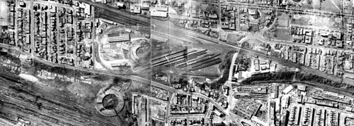
The NDG Jane’s walk earlier this month ventured “below the tracks” to an area that is as fascinating as it is has been isolated over the ages, initially by a natural escarpment, and then by rail and highway development. After talking about the experience with local architect Gavin Affleck, he sent these two aerial photos of the Turcot and Glen yards.
The photo above which dates from around 1930 is centred on the Glen yards which were run by CP. The massive CNR Roundhouse is clearly visible in Turcot yards in the lower right corner.
The cluster of residential streets in the lower central part of the photo is the tip of Village des Tanneries. In the present-day photo below, you can see that the Turcot interchange has lopped off most of the homes to the north of Cazelais street, and the new proposal for the highway would finish off the job, expropriating hundreds more residents.
But the neatest discovery in this photo ia the small, terraced agricultural plots at the base of the Saint-Jacques escarpment, which must have been planted and harvested by Saint-Raymond residents.
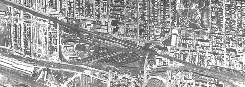
Around 1966, the tentacles of the interchange can be seen creeping into the Turcot yards but the project is still in its infancy. Near the left of the image, are the flattened remains of Minto street, a residential street between Addington and Prud-Homme that was completely flattened to make way for the Decarie Expressway. Just below that, the concrete pylons which would support the elevated highway rise like a row of dominos.

Hard to believe that, in less than a century, this site has been shaped by the coming and going of so much infrastructure and is about to undergo yet another massive overhaul. This 2009 google map will be obsolete in a matter of years. The CPR sold Glen yards in 2001 and the land is currently being decontaminated (ie: dug up and shipped out), to make way for the MUHC Superhospital. The BAPE environmental public consultation on the Turcot project are also underway this month.
But there is less moving and shaking going on around the Saint-Jacques escarpment (falaise Saint-Jacques) This photo shows only the eastern-most tip of the 3-km wide green strip which may or may not consist largely of junked cars, trashed household appliances, and rail-yard debris.
The escarpment is labeled an eco-territory by the city of Montreal and for decades there has been talk among community groups about creating a nature park, cycling link and interpretation centre. But the only thing to show for it so far is the occasional cracked slab of concrete which litters the cliff, remains of a bike path which was constructed in the ’80s and then never used because it had no legal access nor destination. I’ve also heard its great spot for birdwatching, assuming you don’t mind crawling through chain-link to get in.
Nikki Shiebel, NDG Eco-Quartier coordinator and my co-host of the NDG Jane’s walk, explains that, since the territory belongs to 3 different boroughs with a couple of private owners thrown in for good measure, and because “eco-territory” is essentially a meaningless term coined by the city, the chances of this green space becoming accessible – or even cleaned up for the benefit of wildlife – are pretty slim.
In the meantime, at least one creature is enjoying the inaccessibility of the escarpment: this is one of two Montreal area sites were you can find an particular species of endangered little brown snake.
11 comments
Most interesting feature, in the lower right side, is the “switchback” line, which allowed CP trains to get down the St-Jacques cliff to serve some industries in St-Henri. Usually, one will find such swithbacks in remote mountain areas, not in dense urban environments…
There was also a little rail yard (not visible on the picture) exactly where the new Imperial Tobacco head-office now stands.
That “switchback” was ripped about 15 years ago; when the 720 highway was built, there was room in the pillars to accommodate the switchbacking line. As it happens, the road-bed is still quite visible and if it weren’t for the seedyness of the area (the place is filthy with graffiti and shady characters), it could make an interesting stroll for industrial past afficionados.
As Mr. Dufour has pointed out, there was once an interesting Switchback below the CPR.
The ‘Tail’ of this switchback ended below the Westmount City Works just to the North of the-then Tramways St Henri car barns on the N.E. corner of Rue de Courcelle and Rue St Antoine.
The switchback then descended further down to the East, crossing St Antoine on to what is now Rue Bourget to allow CPR rail access to the Imperial Tobacco plant.
The following image shows an Eastbound FREIGHT train passing Montreal West Station on Track FOUR heading East to switch the switchback just East of the Glen.
http://members.shaw.ca/cprclc1/TMPics/CPR8901.jpg
Old Track ONE nearest the station at Montreal West was removed c. 1972, causing Track Two to become Track One, etc.
They used to unload milk in cans from trains onto trucks on Track One for Elmhurst Dairy.
Not to be outdone, CNR had a spur North from their Bonaventure Station lines crossing Rue St Jacques into Rue Bourget from the South.
Dominion Building Materials had a concrete plant South of the CPR on the upper part of the CPR Switchback and their grey Mack mixers labelled ‘DBM’ were once a common sight on the streets in the West end.
For CNR trains exiting Bonaventure Station headed for the Victoria Bridge there was once a single-track wye connection crossing beneath Notre Dame between Workman St and Chemin de la Station.
http://maps.live.com/default.aspx?v=2&FORM=LMLTCP&cp=rkcqv38w17jv&style=b&lvl=2&tilt=-90&dir=0&alt=-1000&phx=0&phy=0&phscl=1&scene=28381400&encType=1
Weststeel, the plant with the tall chimney, used to make LIU ( Lineman and Installation Unit ) and Cable Splicer’s truck bodies for The Bell Telephone Company of Canada before they switched to Van-type trucks c 1961.
American version of Bell LIU as built by Weststeel.
http://www.porticus.org/bell/images/edward_kelly_photos/truck.jpg
The poor old Falaise. The problem started with the railroads as we can see with their roundhouses, so close yet pretty much with their backs to one another (there is a great Canadian metaphor in there somewhere ). Caught in the middle again today where it is pretty much stuck inside three boroughs as stated above.
On the recent visit to Montreal we were in a kitchen on Patricia lamenting the past whilst consuming way too many alcohol substances.
Yes, we talked about ‘Dow’, too!
As we all present had decades of railway service we spoke mostly about the CPR, the CNR, Turcot, the Glen Yard and the Tramways, all being part of our youths.
One thing that came up was that the area where the Glen passenger yard once stood opposite the Westmount Station, apparently, was built up by the CPR with dump cars transporting fill in from another location.
We then went on to conjecture from where the fill was brought by rail, if, indeed, this is true.
It would take a lot of fill along that escarpment!
Alcohol judiciously applied in moderation can expand the thought processes, but, can also expand the BS factor.
Good tunes a necessity.
That is very cool, Roger!
I would like to get street and building pictures of the surrounding area, circa 1920, 30, 40 or 50s. This is for a research book and would pay for pictures or copies.
Interested in anything along Western and all adjoining streets, west of Decarie Boulevard.
Anything along Upper-Lachine to Town of Montreal West. Also including the St-Pierre River below the bluff.
Several years ago, the former Cumming Perrault FORD dealership was moved west and to the south of St. Jacques. A great furor ensued when the owners cleaned out the protected trees at the top of the escarpment so that their sign would be more visible. Like everthing else, it seems that nothing was done to renew this denuded portion of trees and the dealership soldiers along, with presumed soil erosion taking hold of the top of the escarpment.
Hello,There is a video is being made on Decarie and Crowley I would like to know if there is anyone who has pictures of this area dating as far back as 1930’s Please contact me at the above email. Thanks.
WOW!!! Alot has changed in the past 6 years! I just stumbled across this article and it’s amazing how much it is changing now. Things are finally happening!! I just wish I had a time machine so I could avoid the next few years of traffic chaos.
As usual, taxpaying motorists are getting short shifted just so some renaissance-men bikers can enjoy paths paid for by those that actually have a job. If they were smart, they should have expanded the highway to cover the entire escarpment and keep the turcot interchange as well
During the 70’s while driving along St Patrick ( which was coved in spur tracks) or the the 20. One could see that the city of montreal used the western most part of the falaisse as a dumping ground