

Photo from 1850s of Beaver Hall Hill, the Anglo prestige district of the mid 19th century. The street visible in the foreground is modern-day St-Antoine.
In most unequal societies across time the rich have a tendency to stick to themselves, and Montreal is no exception. Throughout our city’s history there have been special neighbourhoods, accessible only to the most wealthy. The recent debate around the Redpath Mansion put the spotlight on one, the old Golden Square Mile. Once a residential neighbourhood for the ultra-rich Anglophone elite of a very different Quebec, it is now in the heart of downtown; its former residents have moved on, leaving behind them a trail of opulent heritage architecture. But the Golden Square Mile is only one of a number of prestige districts that have existed in Montreal. Let’s look back in the city’s history and trace the trail of money through time and space.
The early Montreal of the 17th and 18th centuries was little more than a frontier town of a few thousand people and almost everyone lived within the small territory inside the city walls. One has to wait until the early 1800s to see the first distinction between where the rich and where the common people lived. As the city outgrew the walls, wealthy merchants continued to live in grand stone houses on the inside, while the poor increasingly moved outside the walls to build simple wood shacks in the new faubourgs that were developing around the city gates.
As time went on and the city became larger and denser, certain members of the Anglophone elite built “country homes” on the slopes north of Victoria Square leading up to the mountain, in what was at that time Montréal’s agricultural hinterland. One of the most notable was Burnside, the estate of fur trader James McGill which would go on to become the centre of McGill University’s downtown campus.
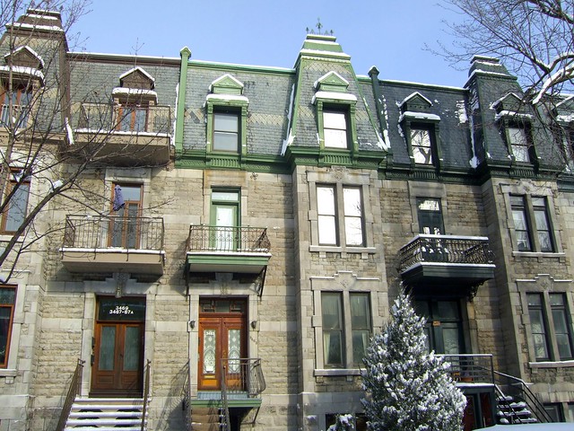
Through the course of the early 19th century, Montreal continued its expansion and much of the Anglo elite left their former homes in the increasingly crowded Old Montreal and took up permanent residence on the lower slopes of the mountain. By the mid-1800s this move was more or less finished. The 1850’s and 60s saw the construction of numerous protestant churches in the area such as the Christchurch Anglican Cathedral as well as the since demolished St. Andrew’s Church (at Beaver Hall Hill) and St. Paul’s Church which was originally built where Place Ville-Marie is located. It was later moved, stone by stone, to become part of Collège St-Laurent. Now located in the heart of downtown, they were in overwhelmingly residential neighbourhoods when they were first constructed.
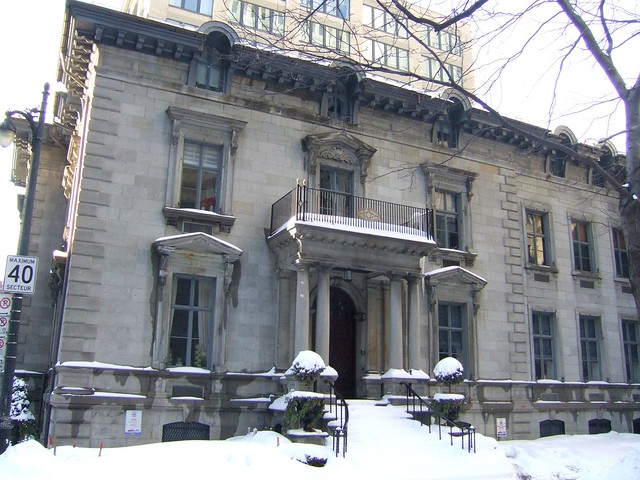
The Dow House, built in 1860 at the corner of Beaver Hall and modern-day René-Lévesque. It is one of the few remaining buildings that hark back to that area’s past as a well-to-do residential neighbourhood.
While most wealth during this period was concentrated amongst the Anglophone merchants, a comparatively modest francophone petty bourgeois district began to form as well, this time around Square Viger. Built in 1857, the Square quickly became a favourite of the francophone upper middle-class, with its beautiful gardens and opulent fountain. They built their homes around it and on the surrounding streets such as St-Denis , Berri, and St-Hubert in what is now the Latin Quarter. The area came to host a number of prestigious institutions such as the Université de Montréal, the École Polytechnique, and the École des hautes études commerciales, a powerful symbol of a newly developing francophone business elite.
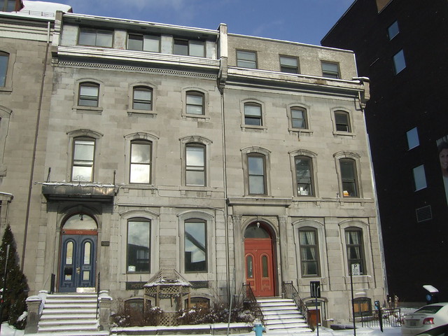
Row houses on St-Denis near de la Gauchetière. Built in an understated Neoclassical style, they would have once housed upper middle-class francophone families. Like much of this part of town they have seen better days.
Very little of these early 19th century neighbourhoods remain. The original merchants’ homes inside the old walls were demolished when the area became a primarily commercial district and most the architecture we see today are office buildings and warehouses dating from the late 1800s. The old Anglophone elite neighbourhood has also largely been replaced by the modern downtown, with few traces remaining. Its Francophone equivalent around Square Viger has been largely destroyed by the construction of the Ville-Marie Expressway and general neglect. Both districts lost heritage buildings to the expansion of Dorchester boulevard, later renamed René-Lévesque.
As the 19th century progressed, Montreal’s growth reached an unprecedented pace. Rapid industrialisation pulled hundreds of thousands of migrants to the city, both poor French-Canadian peasants from rural Quebec and international immigration from the Old World. Montreal’s population doubled between 1870 and 1890, and then again between 1890 and 1910. And like the city as a whole, the prestige neighbourhoods expanded and changed.
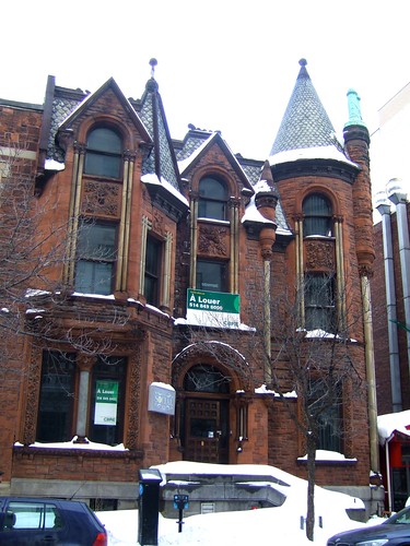
The Peter Lyall House, a Golden Square Mile landmark that was built in 1889.
The Anglophone elite continued its migration further west and higher up the mountain. This was the period of the Golden Square Mile, whose heyday was between 1890 and 1930. There lived the McTavishes, Molsons, Redpaths, Shaughnessys, and other families whose names are synonymous with turn of the century Canadian capitalism. Sherbrooke St. West would become one of the most desirable streets, sometimes being compared to Paris’ Champs-Élysées or New York’s 5th Avenue. Unfortunately, most of the mansions of this era met the wrecking ball to be replaced with office buildings and modernist apartment towers as the city’s downtown shifted from Old Montreal to its present location.
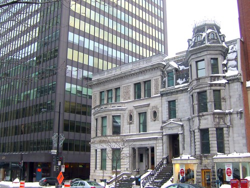
The Lord Atholstan house, on Sherbrooke Street.
On the francophone side, money climbed north of Sherbrooke to establish itself around Square St-Louis and the surrounding boulevards. The striking mansions on Laval avenue are a testament to this era. Unlike the relatively well defined anglo prestige neighbourhood, wealthy francophones tended to live on high-status wide, once tree-lined avenues like St-Denis, St-Hubert, Sherbrooke East, and the streets boardering Parc Lafontaine. Interspersed between these areas were narrower streets housing residents of more modest means.

One of the grandest mansions on Laval avenue, the Pierre-Desforges house, built in 1901.
Unlike its anglophone equivalent, most of the ornate residences of this neighbourhood have survived to the present day. The well-know gentrification of the Plateau could in some areas be more accurately labelled re-gentrification as better off residents establish themselves in sectors which had one hundred years earlier been the haunt of wealthy businessmen, lawyers, and doctors.
More typical Laval avenue row houses, built in the Second Empire style.
By the 1920s and 1930s these areas were increasingly being incorporated into the city’s downtown, and the rich migrated once more. It was during this period that the more well known bastions of Anglo and Franco wealth, Westmount and Outremont, were established. Both these municipalities were founded in the late 1800s, but their growth really took off in the beginning of the twentieth century. By the end of the 1930s the transformation was more or less complete and the stately mansions of the turn of the century were progressively subdivided into apartments as the rich took refuge on opposite flanks of Mount-Royal. This geography of wealth would continue through the end of World War II.

An approximate representation of the neighbourhoods mentioned.
Over the course of more than a century of industrial development (early 19th century to mid 20th), the trend was one of westward migration of Anglophones and northward migration of Francophones. On the map above blue is francophone, red is anglophone. The lightest areas represent the situation in the mid 19th century; Beaver Hall Hill and Square-Viger/Quartier-Latin. The mid-tone is the turn of the century; the Golden Square Mile and the Plateau around Square St-Louis and Parc Lafontaine. And the darkest are early to mid 20th century; Westmount and Outremont. This is hardly an exhaustive list of all areas where the rich have ever lived in Montreal, but it gives and idea of the general trends and an explanation of why our heritage treasures are located where they are across the city.
Since the postwar period, the geography of wealth and prestige is less clear than it once was. The arrival of the Quiet Revolution and the gradual softening of Montreal’s traditionally pillarised society also meant the end of a strict division between the anglo and franco elites. Some people moved to the Town of Mont-Royal, others to the lake-front West Island municipalities, and still others to a wide variety of off-island suburbs. There is also the added complexity of more wealth coming back into the central city, with gentrification and the construction of new exclusive condo developments in the area around downtown. But most importantly, the arrival of the automobile shattered transportation barriers and like urban development in general, wealth sprawled across the metropolitan region, defying the clear spatial categories of previous eras.
14 comments
Excellent Article. I did a search on ‘pillarised’. I have never encountered the word; and was led to a wikipedia site describing pillarised societies in Belgium which I read en diagonal. In the article mentioned there were many other countries mentioned to which other articles on pillarisation were referred. These included almost all of the countries of Europe, South America, Asia and Africa. Makes you wonder why we can’t all get along. It seems to me that pillarisaion simply breeds hate and unhappiness. At least that is my life experience here in Canada and Quebec. There should be school courses on the subject.
Thank you! I’m glad that you enjoyed it; I was afraid that it might be a bit of an information overload. As for the term “pillarised” I came across it a while back as a descriptor for Dutch/Belgium society but I was really struck by how well it could also describe pre-Quiet Revolution Quebec. And yes, I completely agree that it’s really unhealthy and I’m happy that it’s a thing of the past. I remember Phyllis Lambert commenting on this in an interview, saying that growing up in Montreal in the 30s and 40s she found it an incredibly stifling place because of how pigeonholed everyone was and how little meaningful interaction existed between communities. When she came back in the 70s she found that the barriers had dramatically broken down and that Montreal was so much more vibrant and human as a result.
Great piece! Really fascinating and definitely not an information overload. It has a nice narrative flow, actually, as you follow the course of a history, like watching a river chart new course through flood plains over time.
I have one question, what’s the story with Saint-Joseph? It has really beautiful apartments, that are now mainly medical offices, but they look like they were once wealthy homes, either single family or originally divided up.
One real estate agent told me that it was where the early agriculture landowners built their homes, with farmlands stretching out behind. Is that true?
Selon Gérard Beaudet, cette migration des riches autour du mont Royal est très révélatrice par rapport à la structure de la région métropolitaine.
Cet article de 1997 expose certains éléments de sa thèse.
http://www.cgq.ulaval.ca/textes/vol_41/no_112/MA580.html
@Walkerp : Thanks! I’m glad you brought up the question of St-Joseph. I didn’t mention it in the article, but it seems like there were a few other streets with a concentration of better-off residents in the early 20th century, namely St-Joseph and Delorimier. It’s a great irony that many of the Plateau boulevards that are now become mini-highways were once the most desireable addresses in the area. In the East End there were also some more expensive areas in Maisonneuve as well. I decided not to write about them partly because they were more middle-class than truely elite (St-Joseph for instance is mainly composed of higher-quality, spacious appartments, but there are relatively few true mansions), but also to keep the narrative flow from being interrupted by too many caveats and side notes.
Regarding the comment about agricultural landowners, I’m not really sure. That part of town was built up at the beginning of the 20th century. When it was on the edge of town there surely would have been a time when urban and agricultural uses existed side by side, but it would have been fleeting. Urban development was happening at such a fast pace during that period. Just to give you an idea of how fast things grew, here is a map of the city from 1894. As you can see the city is really just downtown, the centre-sud, the southern half of the Plateau, Point-Saint-Charles (not shown on map), and St-Henri (idem). Between the making of this map and 1930s, the following neighbourhoods were built: Mile-End, northern Plateau, Petite-Patrie, Rosemont, western NDG, Westmount, Outremont, Ville-Émard, Verdun, St-Paul, Hochelaga, Maisonneuve, Villeray, and the old core of Ahunstic. It really was an explosion of urban development. Industrialisation provided the economic impetus, and the development of the streetcar network made such rapid expansion physically possible (just like the automobile would allow for the post-war suburban boom).
As for the conversion to medical offices, I would guess that it probably has to do with city zoning regulations. The street started off entirely residential but as it became a busy throroughfare used to funnel east-west traffic throught the Plateau, I imagine that the city decided that it would be a street where they would allow zoning conversions from residential to commercial. In general this is something tightly controlled, so it was probably one of the few places in the area where professionals with their own small practice could get a smallish office in the area.
@ Laurent : Merci pour ce lien. Je n’ai pas vraiment abordé la question du pourquoi parce que je voulais me concentrer sur la description géographique de l’évolution, mais c’est important de se demander pourquoi la ville s’est développé de la manière décrite.
@walkerp
St-Joseph was built at the beginning of the twentieth century, a time when most farmland on the Plateau had already been subdivided and developed. It was first planned by the City of St. Louis, whose boundaries were equivalent to those of the present-day municipal electoral district of Mile End. It was later extended east.
The oldest houses on St-Joseph, in the west, would have been home to upper-middle-class WASPs, who had a significant presence in the neighbourhood until the 1930s. Most of the triplex-style buildings that line the boulevard east of St-Laurent were built in the 1920s and 30s and were home to middle-class francophones. In terms of wealth, I think St-Joseph was a step down from St-Denis and St-Hubert.
What’s interesting to me is how the trends Devin describes were reflected on a local scale in every Montreal neighbourhood, where each street seems to have a different socio-economic status reflected in its scale and architecture.
On the western Plateau, Esplanade in front of the park was clearly a wealthy street, but St-Urbain was more modest, and Clark was clearly quite working-class. Up in the Mile End, the streets west of St-Laurent (Waverly in particular) were much wealthier than those just east of it.
In St-Henri, which is generally considered a very poor neighbourhood, factory managers and the local merchant élite lived in beautiful houses around St-Henri Park, which is like a miniature St-Louis Square. St-Henri’s professional class lived in slightly less luxurious homes around Sir George Étienne Cartier Square.
The historically wealthy portions of neighbourhoods — the Esplanade Avenues, St-Louis Squares, St-Hubert Streets and so forth — were usually the first to gentrify in the 1980s and 90s.
On the same token, Devin’s map is actually a bit inaccurate, since it includes portions of Outremont and Westmount that were historically not wealthy. Lower Outremont, north of Bernard, was a lower-middle-class and working-class neighbourhood. Same with parts of Lower Westmount around the CPR tracks. These areas did not become wealthy until they gentrified in the 1980s.
@ Chris : Thanks for your input. You’re definitley right about Lower Outremont and Lower Westmount. If I have a minute I’ll change the map to reflect that. I’m also happy that you mentioned certain other local pockets of wealth across the city, such Square Sir-Georges-Étienne-Cartier, de l’Esplanade, and Parc-St-Henri. In reality the picture is somewhat more nuanced that what I presented, even if the broad strokes of where the “real” elite (versus local petty bourgeois) lived are correct.
With these sorts of historical articles I find that there is always a tough balance to make between rigour and simplicity. While highly detailed and nuanced articles have clear advantages, at the same time it’s also nice to have articles that present general trends without explaining every caveat. Not to mention the fact that the amount of research required for such a text takes a lot of time and in practice would mean significantly fewer articles written and less topics covered. I always have trouble deciding when I have enough information and when it’s time to throw the article together.
At any rate, I’m glad to see you’re still following Spacing, even though you’re on the other side of the world now!
Thanks a lot for those great responses. So fascinating. Part of what makes Montreal such a cool city historically is that you can still see so much of that history. Yes, much is lost and what remains is often barely visible under layers of decay, change and “renovation”, but it is still peeking out, making us think of a lively past.
L’église St. Paul était plutôt construite du côté sud de la rue, soit à l’actuel emplacement de l’hôtel Reine Élisabeth.
Very interesting article. One feels the ebb and flow of the evolution of a city. It would be interesting to extrapolate over the next 50 years or so taking account of the changing perceptions of what the ideal city should be (from a machine for working in (Le Corbusier and the Montréal administration of the ’60’s and ’70’s (sublime to the ridiculous)) to that of the pedestrian-friendly city of Projet Montréal today. And of course decline of the suburbs and private car use.
I am nevertheless afraid that the more the city becomes agreeable to live in the more it will be expropriated by the rich and many of us will be forced further and further away. This a tendance lourde observale everywhere. In my twenties I could live in more or less any part of Central Montréal I wanted (I even had an apartment in front of Ogilvies at one stage).
It would have been interesting to trace the movement of the jewish community, too, as they moved from St-Laurent street to the north side of the Mountain, west of Outremont and then on to Côte-St-Luc.
@ David : Yes, I completely agree with you. My greatest fear that Montreal will slowly be “Parisified”. That is to say, the historic core will become lovely and wonderful and only accessible to the well-off, and the poor will be stuck living in really crappy, deteriorating, immediate post-war suburbs. I am 100% behind efforts to make the core of the city walkable, green, family-friendly, etc., but without a concerted effort to ensure access to housing for everyone, there could be some major unintended consequences.
@ Emdx : Well, you seem to have gotten the general trend right. More specifically the evolution of Jewish neighbourhoods goes something like this: (modern-day) Chinatown => “The Main” => Mile-End => Côte-des-Neiges/Snowdon => CSL/Hampstead (and to a lesser extend DDO).
Hi Devin, what a fascinating article! I came across it whilst researching a paper I’m writing for my university back in London and it’s really given an interesting new perspective on my original topic, which was the gentrification of the Plateau in the last 60-ish years. I was just wondering where you sourced all this information/knowledge? I’m always on the lookout for new articles and books etc!
Bethany
Thank you for your comment, Bethany. An indispensable tool for most of the historical articles that I write is Pignon sur rue by Michèle Benoît and Roger Gratton. It’s really an architecture book, but it talks about the history of neighbourhoods and urbanisation too. Another useful source was Jean-Claude Marsan’s Montreal in Evolution, a very detailed yet accessible overview of Montréal’s history and urban development.
And finally, another significant source was Montréal de vive mémoire, which documents neighbourhood histories from the perspective of personal histories. They are all really good publications, but their focus tends to be earlier than your period of interest.