In my last entry I talked about Montreal’s Aqueduct canal and its role in bringing water to the city of Montreal. In this entry, we’ll begin to go underground, but first, a bit more history…
I mentioned the use of hydraulic machinery and how it was powered by water by the aqueduct. Only a small portion of that water (less than 5%) was actually sent through the pipes and into homes and businesses. By the late 1800s, several problems with this system started to make it less than ideal. The first issue was that demand for water was increasing and more horsepower was required to distribute it. The aqueduct at the turn of the century, roughly a quarter the width it is today, was incapable of providing the hydraulic horsepower necessary to power the pumps.
On top of this, the success of system was often at the whims of mother nature. Low water levels in the summer and ice blockages in the winter frequently reduced pumping capacity. As a result, steam power, which was both cost and labour intensive, would then have to be used as a back-up.
Another problem was that the water was being brought in directly close the shoreline of the St. Lawrence River, which by this time was starting to become less than pure. City officials maintained that the water posed no health risks. However, there was a concern that drainage from properties situated upstream of the entrance to the aqueduct had the potential to cause future problems. Given that there was still no filtration process yet in place (and wouldn’t be until the early 1920s), engineers were starting to become somewhat mindful of what could possibly be entering the city’s water supply.
20th Century Solutions
To address the shortage of available horsepower, in 1907, after two decades worth of proposals and deliberations, it was decided to widen the aqueduct from 40 to 140 feet. Along with upgrades to pumping equipment, the alteration would provide a total of 2,500 HP during the winter months. A rate of 5,000 HP during the summer was achievable when the aqueduct was free of ice, or ‘frazil‘.
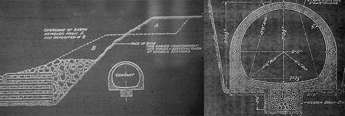
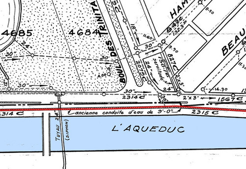
To help improve quality of water, a 9’ concrete conduit running underneath the aqueduct’s north shore was built between 1907 and 1909. In addition, the intake for this conduit would extend towards the middle of the St. Lawrence, where the water was less likely to contain sediment. By enclosing the water inside this underground pipe, the risk of further cross-contamination would also be diminished. The conduit would also serve as a continuous water supply while the aqueduct was emptied during its widening.
Rumour Has It.
I first learned of the conduit a couple of years ago, not through the city archives or maps, but from a message board dedicated to Verdun . In a bit of oral history, an older member recollected a time during his youth when he and his friends would open a manhole cover near the north side of the Crawford Street Bridge and climb down into a ‘9 foot pipe.’ This was enough to pique my interest. I decided to go have a look for myself.
When I arrived, the only manhole I could find in the area was now in the middle of Blvd De La Verendrye- a rather busy thoroughfare. If it was the same one he entered, then it must have been before the 1960s which was when they built the road . I walked further along the street hoping to find other options, but every single one was situated in the road. Feeling a bit dejected, I filed it under ‘things to look for if ever bored’ and left it at that.
A few months passed before I came across another reference to the conduit, this time in a city planning document from the 1930s. I learned that the pipe was connected to the waterworks system. A few weeks later, when Controleman came back from the City Planning department with a handful of sewer maps, one of which made clear where the conduit ran, that it was no longer in use, and more importantly, where the best point of entry was located.
In what I consider to be a continuation of underground exploration traditions, our entry point ended up being but a few feet away from the manhole that the older gentleman from Verdun once used. A three foot high drainage pipe within Parc Angrignon, just large enough the crawl through, provides a 21st century means of access.
Inside the Conduit.
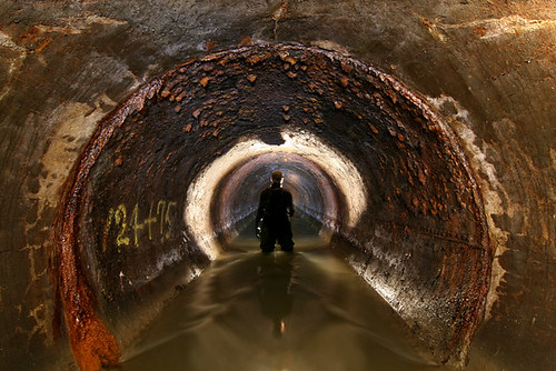
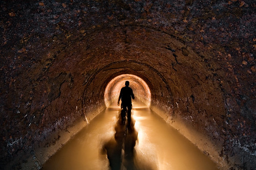
The conduit itself resembles many of Montreal’s older concrete sewers, but with pronounced horizontal lines from the wooden forms that were used during construction. For a century old tunnel, it’s in excellent. The water is, at times, thigh-deep, but it is slow moving and not that much of an issue assuming you have the stamina to wade through it for long periods of time. Sewage can be detected, but for the most part the water is cleaner than what is usually encountered underground in Montreal. I wouldn’t want to drink it, but I wouldn’t mind falling in it either.
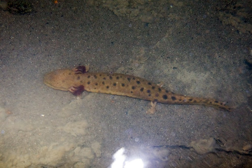
As a testament to its cleanliness, small fish can often be spotted over the course of its length. During one trip, I even came across about a half dozen mud-puppies that somehow got swept into the system and have done their best to make this dark tunnel their home.
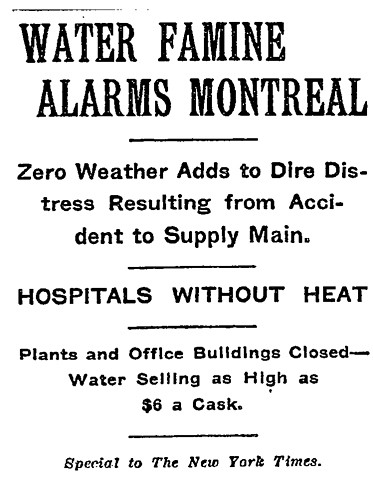
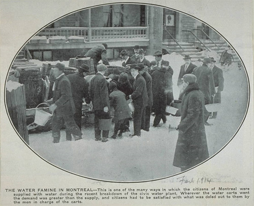
The Montreal Water Famine of 1913
By the winter of 1913, work had begun to widen the canal an additional 25 feet. This further widening was commenced to help generate electrical power for the city’s lighting systems. Rather than have to expropriate additional land on the south side of the canal, the City decided to make the enlargement on the north shore instead, close to where the conduit ran. It’s here where all sorts of problems began.
In the midst of this second enlargement, a two-foot long portion of the conduit was damaged. Workers did their best to try and repair the break, but a few days later, sixty feet worth of the conduit collapsed. The damage left close to 300,000 people in Montreal without a proper water supply. Adding insult to injury, the event occurred on Christmas Day — never a good time for catastrophe to strike.
City workers scrambled to repair the break while the people of Montreal had to receive water through water carts or from properties fortunate enough to have access to Cartesian wells. In one instance, Ogilvy’s department store, with a 1,200 foot deep artesian well in its basement, was able to provide water for people in the area. Meanwhile, large factories such as the Angus Shops had to be temporarily closed, while streets were patrolled day and night to react quickly to the first sign of fire.
The conduit was eventually repaired four days after its collapse using sections of boiler plate riveted together to form a steel pipe. Wasting no time, the city decided to let water through the length of the conduit as soon as the concrete surrounding the pipe had finished setting.
The joints held, and close to a century later the steel pipe can still be found. It’s a great deal rustier, but despite this, it’s holding up well.
While the conduit repair was successful, the city’s confidence in its water supply was severely shaken. An investigative report submitted to the city’s Board of Commissioners blamed the collapse on both the materials used during construction of the conduit as well as the excavation that had been taking place at the time.
More importantly, the report made several recommendations that would help prevent another such calamity from occurring. Based on the report, an emergency supply pipe running from the Lachine Canal to the pumping engines was soon added as a temporary solution. Ensuring a more reliable back-up supply system wouldn’t come until later.
Yesterday and Today.
It’s not clear at this point when the city stopped using the conduit for its drinking water supply. It likely became obsolete by the time the filtration plant was put into operation during the 1920s. Impure water running the length of the open aqueduct was less of an issue after that. Repositioning of the system’s intake pipes probably also ensured a cleaner supply as well. Also unclear is when (and why) the City officially abandoned its plans to use the aqueduct for purposes of power generation.
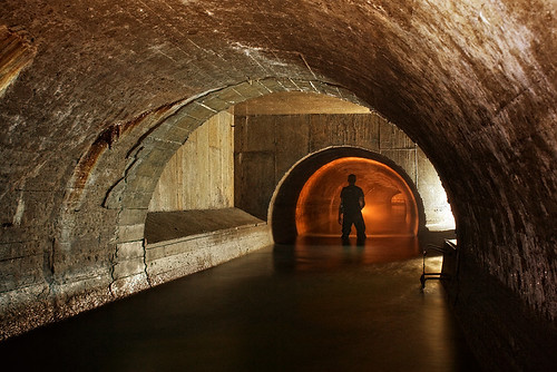
Today the conduit is still in use, both as a sewer for LaSalle and what I’m assuming is an overflow tunnel for the Charles Des Baillets water purification plant. The aforementioned relatively clean water and levels of sand (fare probably attributable to the plant’s filtering system. A walled off section prevents water from the River from entering the conduit directly. Before this, a section of the conduit has been replaced with a junction chamber with one pipe leading towards the discharge tunnel of the plant.
Given that there is currently only one known feasible entry point into the conduit, walking its entire length (and back again) would be a formidable task involving a 16 km round trip. To this date, I’ve walked roughly half its length, but I’m going to have to find other ways in if I’m to see the remaining portions.
Cross-posted from Undermontreal




6 comments
Great work, well documented. I love your series and I cant wait for the next installement.
As usual, absolutely fascinating. I wonder what, if any, effect the polio scare in the 50’s may have had on the water systems in Montreal. Up to that time people used to swim in the Saint Lawrence but suddenly it became a dangerous thing to do and was seriously discouraged.
Thanks. Given the amount of sewage that was draining out into the Saint Lawrence, I’m guessing polio was probably one of the reasons swimming was discouraged. I imagine it was even worse for areas along the Back River.
The St-Lawrence is extremely swimmable, on the south-shore.
The north shore (along Montréal island) is disgusting, thanks to the Ottawa river. If there is a filthy river, the Ottawa is it, thanks to wood floating and paper mills.
But upstreams from Pointe-des-Cascades, the St-Lawrence is absolutely pristine. (In Pointe-des-Cascades, the Soulanges canal is a very interesting dive spot).
I have seen 100 feet visibility in the Thousands Islands; on a wreck, 120 feet down, the light was extremely good.
Very interesting write up, nice work.
I am also very interested in the Aqueduct. Although not as thorough as your research, I have written an article on the subject for our quarterly revue “Les Argoulets” as a member of the Société d’Histoire et de Généalogie de Verdun. I am presently gathering information on the old Petite Rivière Saint-Pierre including the Petit Lac Sain-Pierre also called Lac à la Loutre. At a meeting at the Dawson Cultural Center, someone asked how many bridges crossed the Aqeduct and nobody had the answer. In the summer of 2007 I decided to take my bike and took pictures of the bridges alongside the bicycle path and counted 10 including the LaSalle Boulevard pumping station. These photos can be viewed in Album No. 3 on my following website:
http://shgverdun.multiply.com/photos
Guy Billard
guy.billard@sympatico.ca