
What is the best use of public land? Who should be privileged with the best views of the river? How does national identity intersect with everyday use?
These are just a few of the questions asked by fourth year Carleton Architecture students this past semester. Looking at Pinecrest Creek in the west end, the team questioned how to address the gaps created when utopian creations several decades past are now home to families with less resources; the gaps created as beliefs about lifestyles evolve while the context remains the same; and the possibilities created when major infrastructure is reworked, as is the case with the construction of an LRT. As there will indeed be an LRT line serving the area within the relatively near future, the answers to these queries become increasingly pertinent.
The Pinecrest Creek area posits an intriguing project site through which to explore the many components that make up a city. Particularly, the existing conditions are relevant both here in Ottawa in a number of neighbourhoods, and throughout North America. As Ottawa is our nation’s capital, we can use the site to put forward best practices in the design of public space and revitalization of mid twentieth century development. Major components of the site that needed to be addressed were:
- The Sir John A MacDonald Parkway
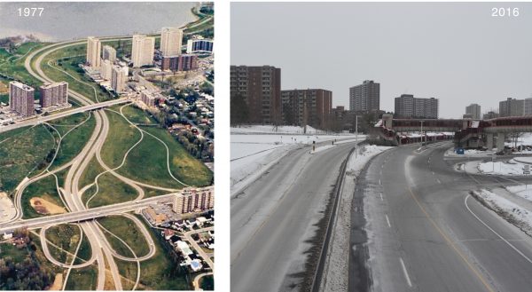
It spans 10km from downtown to Lincoln Fields, with only three connections on the duration: at Parkdale, Island Park, and Woodroffe. With two separated roadways at two lanes apiece, a speed limit of 60km/h, and an average actual speed of closer to 80km/h, the parkway effectively cuts off most adjacent residential fabric from the water. There is one two-lane multi-use path along the water’s edge for all other users; at many points the proximity of this path to the roadway is tight enough to make non-vehicular users uncomfortable, and renders the path entirely useless during the winter due to snowbanks. - The Transitway
Currently, the Transitway utilizes the Parkway from Dominion station to Lincoln Fields, a distance of approximately 4.9km, or half the length of the Parkway, with a number of bus routes utilizing Woodroffe. So, while the Parkway currently has a public use as a transit thoroughfare, once the LRT is complete, the Parkway will solely host private vehicles. Once at Lincoln Fields, the Transitway continues south and is transit only. Again, this thoroughfare will be replaced by an LRT line. - Pinecrest Creek
Buried beneath the last stretch of the Parkway, Lincoln Fields, and a bit of the Transitway, is Pinecrest Creek. Piped in the 1960s to accommodate development of the area, Pinecrest Creek goes underground alongside Woodroffe Highschool and remains underground until its outlet at the Ottawa River, alongside Mud Lake. As the LRT does not require near the amount of paved impermeable surfaces of the current transit system, there is an opportunity to reconfigure this infrastructure and daylight the creek. - Modernist towers in parks
Anchoring the western-most end of the Parkway is a number of twenty-plus-story towers, built as per the modernist utopian ideals. Again, these parks are cut off from the river, and in often cases fenced against one another. - Residential fabric comprising nearly entirely of single family detached homes
Again, built in the 1960s, the area was envisioned to be a west-end haven for upper middle class families: the classic two parent, two kid, two car setup. At an average price tag of $35,000 per home, the houses were far more luxurious than the Ottawa average at the time, a meager $15,000. However, several decades later, demographics show that, while there are still some dual-parent families, many households are single parent families, single occupancy, seniors, and/or much lower income than the Ottawa average. The lifestyles of the current residents often do not include a car, and are equally ill suited to either a single-family detached home, or one-or-two bedroom apartment. Revising the built form to reflect these demographics, effectively closing the gap between 1960’s ideals and current realities, would have profound impacts upon the neighbourhood. - Lincoln Fields Shopping Centre // Commercial Amenities
With the withdrawal of Walmart and revitalization of other neighbouring malls, Lincoln Fields needs at the least to be revamped. An LRT station will be located at the current Lincoln Fields transit station, effectively directly connecting the mall as far as downtown, and acting as an interface between the LRT and the Pinecrest community.
In addition to researching these physical components of the neighbourhood, the team undertook a number of community consultation sessions to get a better feel for the social fabric. Students from Regina Street Public School’s Mud Lake Program got involved, seniors through Carefor, Parkdale food bank and the local stylist all provided very valuable insight about their wants and needs, which greatly informed the students’ work and further helped to ground the project in reality.
Ultimately, the final project is part urbanism, part architecture; it leverages a linear park to revitalize older infrastructure, daylights a creek to improve the ecology of the area, and infuses new commerce through several insightful, well placed mixed use buildings.
See the final project here: https://pinecrest-renewal.squarespace.com/
The site model and panels are on display at the Main Branch of the Ottawa Public Library, 120 Metcalfe Street, 3rd floor.
Story by Robin Woollacott and participating students
Edit note: Please note an earlier posted version of the story mentioned a discussion at the NCC urban lab on June 8. Unfortunately the discussion will not be open to the public as previously reported.