
 Five years ago when I was a resident at the Canadian Film Centre’s Media Lab we would brainstorm possible new media programs/applications/devices/things that we could create content for. Lots of ideas involved the city and, more importantly, locations in the city. We thought about how to deliver content and information to those locations — information that was specifically about that location. The problem was our ideas were way ahead of the technological solutions at the time. Devices either did not exist with the capability we needed or the technology was far too expensive or clunky. Eventually we developed [murmur] there and it avoided the technological issues by simply getting the user (in this case, somebody who wants to hear a location specific story) to give us their location manually (by typing the location code into their mobile phone). Easy, cheap and low tech.
 Fast forward to 2008 and we have the iPhone (and similar GPS enabled devices). I resisted for four days when it was launched in Canada back in July, but broke down and got one. My immediate reaction was that the iPhone effortlessly does all the stuff we wished a device could do back in 2003. It knows where you are and can tell you things about your surrounding area. Those things could be restaurant locations, various nearby Twitter users, what your neighbours are listening to on Last FM, and now, with the release of the Red Rocket iPhone application, TTC information.
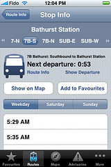
I installed it on my phone earlier this week and have been using it around the city. It is quite a big download as it comes with a lot of information embedded in it (rather than pulling it off of the network as you need it) which is necessary as it needs to work when in subway tunnels that haven’t yet been (un)wired (soon, please!). It comes with information on each bus route, maps of the subway and streetcar lines as well as an automatic RSS feed from the TTC (for transit advisories) and updates from the Transit Toronto blog. The futuristic-for-2003 part is that you can ask it to find the closest TTC stops for your current location. Though I knew the main TTC routes that went through North York on my Toronto Flaneur hydro corridor walk on Sunday afternoon I could have found out what the closest stop was at anytime, including more obscure routes that I’m not familiar with. I admit I used the iPhone’s Google Map application to figure out a way around an uncrossable stream.
 Most useful is that Red Rocket will tell you the next time each TTC vehicle is due at that particular stop (on routes where information is available). An interesting point is the developers decided to use non-TTC stop-time information gathered by MyTTC.ca contributors because “we believe that MyTTC times are more accurate than those posted at your stop or station”. Ideally the TTC will one day also open up their internal (publicly owned) data to feed 3rd party applications like this. While Red Rocket is something the TTC themselves should have created, it’s likely done considerably cheaper, quicker and more nimbly by an outside firm. “Nimbly” in the sense that a small firm can respond and makes changes quicker than a bureaucracy with 50 years of staid momentum (this opinion is simply based on how long it has taken for the TTC to update their website and install “next bus/streetcar/subway” technology). If all that (public!) information was freed up, talented designers and programmers could create things we haven’t dreamed of yet.
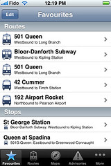 The application was developed by a two-person software development team in Toronto who point out that this is their 1.0 version, and future iterations will be tightened up and expanded. They hope to gather feedback from early users in order to make it better. I look forward to expanded stop information on routes that don’t currently list that information, and more detailed route maps that shows bus routes as well as a drill-down function that allows us to see each individual stop on all the surface routes.
To check it out for yourself, head to the iTunes application store and look up “Red Rocket.” It will set you back a cool $1.99, about as much as I paid for a TTC ride when I first moved to Toronto.

26 comments
Will they be updating frequently when routes change? Virtually every route in the city will have service changes in a few weeks when the much-awaited RGS improvements happen (service till past midnight on all routes, maximum 30 minute headways, lowered maximum loading standards). Given that this is from a third-party data source, I wonder how many days/weeks it will be wrong after the RGS changes come in?
The screenshot of the subway map includes streetcars. Something the geniuses designing the LED-illuminated subway maps in the new subway cars could not figure out. Exasperating.
@David: we’re already working on it 😉
George & Hilary (and anyone else who wants it!) will have the data very shortly after we’re finished.
@David: Which is all the more alarming considering the TTC itself doesn’t deign to update its service charge notices long after they’ve occurred (see paper notices left to rot in rain and snow).
meanwhile Montreal has Google Transit and Toronto… doesn’t.
“While Red Rocket is something the TTC themselves should have created, it’s likely done considerably cheaper, quicker and more nimbly by an outside firm.”
Except TTC will still probably use consultants to create their super-whizzbang-trip-planner anyway.
@Kieran: terrific, this makes me wish I lived in Toronto (as opposed to Durham) and owned an iPhone. 🙂
Somebody really needs to bring this to Metrolinx’s attention. They should be facilitating making this data available for all systems and supporting independent work like this and myttc.ca.
…I was just testing out Google Transit in Montreal — pretty impressive indeed, given that it includes info from (I counted ’em) 18 different transit companies that serve the north and south shores. With so many companies, how is it that Montreal is there, but Toronto is not?
I use the app on an iPod Touch. Although this means that it only can find your location if near an open wi-fi connection, it is still impressive. There are a few bugs including use of bus icons for streetcar routes – and missing schedules for some routes. However, no doubt this will be fixed in future upgrades.
There is also another TTC schedule app called iTTC. Although it has fewer features it does a decent job.
It’s nice to have a surplus of options.
@David: Mark Kuznicki (and others) have a discussion online at http://metronauts.ca and offline at various transitcamps around the GTA that are being curated and submitted to Metrolinx. I’ll be talking about open data and transit information @ Metronauts in the next few days – I hope it will spawn a good discussion.
@Tristou: It’s largely an open access to data issue – Montreal has made their data available to Google (and others) in an open format. Incidentally, we’ve made our data available in the same format so that Google Transit (or anyone for that matter) can use it. Google would (understandably) prefer to get this data from the agency itself, whenever possible.
Someday, You People will stop acting like outsourcing irreplaceable Canadian public data to a U.S. corporation with an inaccessible interface is a good idea.
Google Transit (the team, not the application) have done a wonderful job of helping define an open data spec – they have been and continue to be very inclusive of developer feedback.
I’d agree that their interfaces could use some attention (especially on the accessibility front) but I don’t mind their service supplementing an agency’s (or public 😉 ) effort done properly.
Hmmm… this discussion may be more productive in an upcoming metronauts post – I hope to see you all there!
Uh, Joe, you realize that the pixels you see on your screen right now probably passed through seven US universities, a couple multinational corporations and a defense contractor on their way to your computer? The internet, and digital information, does not mesh well with nationalist barriers. (Neither, for that matter, do streetcar contracts. The world has gone flat.)
In the screenshot, I don’t get why you would include streetcar lines, but exclude bus lines.
In every other city in the world — Philly, SF, Boston, etc. — streetcars or LRT appear on the rapid transit map. Nothing against buses but that is just convention. Toronto has been backwards for so long that people have forgotten how the rest of the world works. Maybe grassroots apps like Red Rocket will turn things around by treating rail like rail.
And while on the topic of graphics, those articles in the Star on the signage at Union are right on. No professional graphics agency would design such garbage. Visit a modern airport or college campus for proper wayfinding examples.
Joe
open access to data != outsourcing. Google are not looking for exclusivity. Stop trying to make this sound like the Lockheed Martin deal on the census or something.
uSkyscraper: But streetcars provide service that is equivalent to bus service. That’s not true in most other cities, which generally have better tram service than Toronto.
Isn’t it misleading to put streetcar lines on a rapid transit map, and not buses? Why not exclude both, if you’re not going to include everything?
We decided to include the subway and streetcar maps together as they’re both rail lines that receive a lot of ridership. Also, we wanted to keep the map clean for at-a-glance use. In the future we’d like to provide route maps for the busses too.
“uSkyscraper: But streetcars provide service that is equivalent to bus service. That’s not true in most other cities, which generally have better tram service than Toronto.”
It depends what you mean by “equivalent”. While downtown streetcars do not run in private right of way, even the non-articulated cars have higher capacity than buses.
Classifying them as “higher order” is something of a statement of intent – we should be demanding that the TTC add more streetcar service and demanding the City and Toronto Police to do more to ensure their passage is not unduly impeded by private cars and unprioritised traffic signals as it is now on some choke points.
Mark: Streetcars are certainly equivalent to buses from the perspective of getting from A to B. This iPhone app is meant for riders, not urban planners. A rider only cares about capacity if the capacity is less than demand, which happens both on bus routes and streetcar routes.
As for classifying the streetcars as “higher order”, their current mode of operation hasn’t changed in close to a century, so that classification seems somewhat meaningless.
Unless this is some kind of deathbed conversion, I understand Google Transit’s advocates to be calling for data to be turned over to a foreign corporation so it can give us a trip planner instead of waiting for the TTC to get around to one. At that point, Google advocates won’t even bother waiting for or asking for a real TTC-owned trip planner anymore because they will consider the problem solved.
Who developed the data, who owns it, why should a foreign corporation tell me how to get from one location in the 416 to another, and how am I supposed to use the interface if I have one or more relevant disabilities?
If, all of a sudden, you’re trying to suggest it’s a more-the-merrier scenario and anyone, not just Google, should be able to develop a trip planner, well, what the hell do you think just happened? Somebody other than Google already did develop trip planners. But it’s not the real thing until Google does it. Right?
The TTC has spent years developing its own geospatial data – at immense cost and worth every penny. A public institution has to own its own data. Now, it may later license it to other parties, but the data has to be public. What we’ll end up with is more than one set of data. I just don’t want a foreign juggernaut owning the only set, and I want Google advocates to stop acting as though, once Google gives us what the advocates want, every single wrinkle of the issue is resolved.
@Andrew
Although many TTC streetcars don’t have their own right-of-way, some do. E.g. Spadina has dedicated lanes, which will be faster than buses would.
Joe: “TTC has spent years developing its own geospatial data at immense cost and worth every penny” — do you remember iridium, the satellite phone? It, too, was developed at great cost, and arguably worth every penny since you could phone from anywhere, not just close to a cell phone tower. Well, it just didn’t fly with consumers, who prefered the smaller, cheaper cell phones and could apparently live with not receiving calls the middle of the sahara or at their cottage by the lake.
As for ownership and duplicates: well, as long as TTC feeds Google, they control and own the data, don’t they?
Montreal’s STM has had its own trip planner for years now — and lo and behold, they’ve now put up a link to Google right beside their own at http://www.stm.info/english/azimuts/a-index.htm. They mention the extra options their own trip planner offers, but in fact, I prefer Google: it shows you the map of your trip, it’s less clunky and easier to use, it’s quicker, and it covers all the transit companies around Montreal, not just the STM.
Seems to me that they don’t have a problem with handing over their data to a foreign juggernaut, and hey, if Google has built a better interface, I’ll use it. But I’ll still buy my carrots and mushrooms at Jean Talon market grown from local farmers, okay?
The next version of iPhone/iPod Touch Software 2.2 will have Public Transit Capabilities. Given the close ties between Apple & Goggle, I presume the public transit software will run on Google Maps and require transit data in a Google format.
The details, including (Google Map-like) screenshots were released on AppleInsider: “iPhone Software 2.2 to add public transit & walking directionsâ€Â: http://www.appleinsider.com/articles/08/10/25/iphone_software_2_2_to_add_public_transitwalking_directions.html I’d be interested, once V2.2 released to know if the walking portion shows Shawn a “better way” around the uncrossable stream he encountered on his weekend walk than Google Map (Walk option).
Unfortunately, the TTC is a Blackberry/Windows-only shop (or was the last time I asked TTC CIO in Spring) and all the Senior Execs use Blackberries… so they likely won’t “get†the iPhone’s appeal (despite selling more smartphones than Blackberry (see AppleInsider: Apple iPhone 3G sales surpass RIM’s Blackberry @ http://www.appleinsider.com/articles/08/10/21/apple_iphone_3g_sales_surpass_rims_blackberry.html)
If there is one saving grace, TTC Chair Adam Giambrone DOES use a Mac at City Hall and DOES get technology (Robert Ouelette’s/Torontoist TTC website challenge and follow-up Transit Camp) was/is pushing TTC Staff hard behind the scenes to implement long overdue website redesign, TTC Trip planner and soon hopefully, real-time, anywhere (AVL) vehicle location~the holy grail of transit information.
Iridium was hardware. Data are data.
@Bob
I have little doubt that the Blackberry Storm will have an equivalent Google Maps+Transit add-on, just as the current Blackberry has Google Maps+GPS.
TTC being a Windows-Blackberry environment is unsurprising – most large corporations in Toronto are. iPhone is (mostly) a consumer device, just as Blackberry is (mostly) a corporate device. That’s changing, but slowly. As a Blackberry Enterprise Server administrator, I find the remote administration and remote disable functions critical – and that fact that buying Blackberry is supporting many high-paid Canadian R&D jobs doesn’t hurt either.
The critical issue is that TTC open the data fully so that if someone out there can do a better job than TTC or a corporate licencee then they should be free to take a whack at it. After all, we’ve seen what a poor job TTC does when they licence their brand to a merchandiser – who’s to say that armed with official data either myTTC or someone else wouldn’t do with transit planning what Spacing did with the buttons?
This makes me want to get an iPhone.