

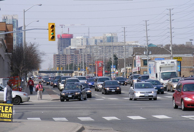
 Modern condo towers in Mississauga City Centre and traffic on Hurontario Street overwhelm old Cooksville
In 1794, one year after the founding of York, Governor John Graves Simcoe ordered the construction of two military roads: Yonge Street, heading north to Lake Simcoe, and Dundas Street, heading west from Cootes Paradise (at what was later the town of Dundas, since absorbed into the City of Hamilton). Both streets were named for prominent British figures; Henry Dundas, Viscount Melville, then British Home Secretary (George Yonge, a friend of Simcoe’s was Secretary of War).
The original purpose of Dundas Street was to link Lake Ontario with Simcoe’s preferred location for the capital of Upper Canada, on the Thames River at London. However, plans for that townsite were soon dropped and with York as the new capital and commercial centre of the new colony, the road was extended east to the new city. (Dundas Street was planned to extend as far east as Kingston, but this was eventually built as Danforth Road/Kingston Road, though in some places, such as Belleville, the Dundas Street name prevails.) As a military road, Dundas Street kept a fair distance from the lake to be an effective alternative route in the case of war.
It took a while for the Dundas-London part of the road to see much settlement, but farms and villages quickly developed near Toronto. Communities included Brockton (an incorporated village for three years before annexation by Toronto in 1884), Lambton Mills, Islington, and Cooksville.
Cooksville, the subject of today’s post in this intermittent series, is not totally “lost”. But it suffers from benign neglect, even though it remained an important local centre up to the early 1960s, long after many other “lost villages” declined. In this case, municipal amalgamation and rush to build a new city centre to the north helped cause Cooksville to languish.
At the corner of two early, important roads, Dundas Street and Hurontario Street (so named as it connected Lake Ontario with Port Credit with Collingwood on Georgian Bay, part of Lake Huron), Cooksville thrived. It became the seat of government for prosperous Toronto Township, yet never incorporated as nearby Port Credit and Streetsville did. While the Great Western Railway’s Hamilton-Toronto branch, opened in 1853, ran well to the south at Port Credit, the Credit Valley Railway’s line to Orangeville (later part of the CP empire) opened in 1871, with a station right in town. In 1917, the Toronto Suburban’s Guelph Interurban began serving Cooksville. A large brickyard just to the west (near present-day Mavis Road) provided a further economic base.
But by the 1950s, Toronto Township began urbanizing as a suburban satellite to Metropolitan Toronto. Ranch houses, factories and shopping plazas began filling the land between Dundas Street and Lake Ontario as outgrowths of Port Credit and Etobicoke’s southern urban tier. In 1968, Toronto Township became the Town of Mississauga, and in 1974, municipal restructuring of the former Counties of Halton and Peel resulted in the City of Mississauga.
As Mississauga transformed from a rural, mostly agricultural, township to a major suburban city, Cooksville got no respect. The new, shiny vision for the Town of Mississauga (and the successor city) was a new city centre surrounded by a super-regional shopping mall in the municipality’s geographic centre.
Cooksville’s role as the administrative centre came to a close, with a new, larger town hall at the corner of Hurontario and Robert Speck; the old 1953 modernist town hall was turned over to Sheridan College and for school board administrative offices. In 2009, the old town hall, which had some interesting friezes, was demolished after sitting abandoned for several years. (In turn, the 1970s civic centre was replaced by the post-modern Mississauga City Hall.) The brickyards were closed in the 1980s and replaced by big-box shopping. And just last week, the old trailer park, a relic of Cooksville’s small town era, closed for good.
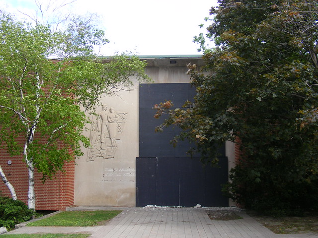 The demolished Toronto Township/Town of Mississauga offices. The frieze on the left is a map of the township, representing the economic diversity of the region, such as Malton Airport and industry in Lakeview.
The wildly successful Square One shopping centre represented the new era; Cooksville seen as a relic of the past. The CP Station was demolished in 1975, many of the old commercial buildings were removed in the 1950s and 1960s to widen Highways 5 and 10. Modern strip plazas replaced the old village hotels and shops.
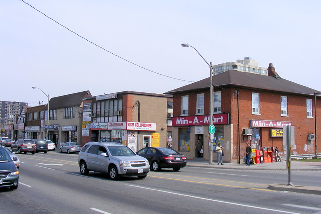 Some remaining commercial buildings on Dundas Street
Today, Dundas and Hurontario remains a busy intersection. It is the transfer point for two of Mississauga’s busiest bus routes, and GO Transit opened a station at Cooksville in 1981 when it started the Milton commuter service. Still, it remains in the shadow of the condo towers at the new Mississauga centre to the north, and apart from the Cooksville Common office building (with a new library branch) built several years ago, little new urban investment has been made in the area.
The small parkette at the southeast corner of Dundas and Hurontario, a well-used meeting place, is neglected and and in need of TLC. This is despite the fact that Port Credit was named by Spacing as the best public space in suburban Toronto, and the city just completed Celebration Square, a fine renewal of the public space at its current Civic Centre.
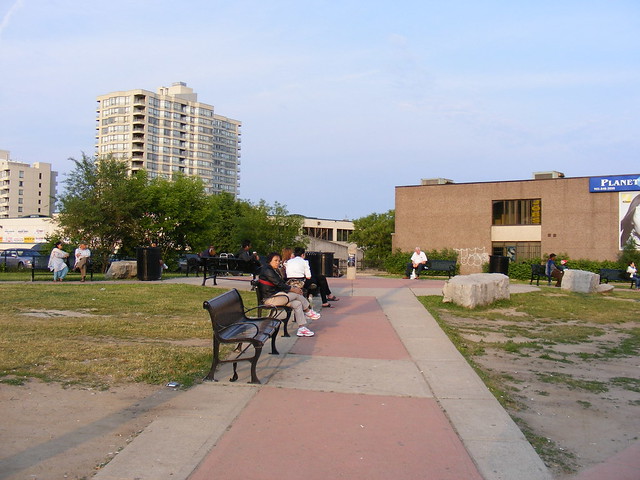 The shadeless public square at Cooksville is rather sad, and we know Mississauga can do much better.
Yet there is hope for Cooksville, and even despite suburban sprawl and benign neglect, several of the old buildings are still standing, and the old strip plazas, with many shops catering to the local Middle Eastern, Persian and South Asian communities, are thriving. What Cooksville now needs is some civic recognition and investment, and to be recognized as much more than just a GO station. Hopefully, if built, the Hurontario-Main Street LRT will help in this respect.
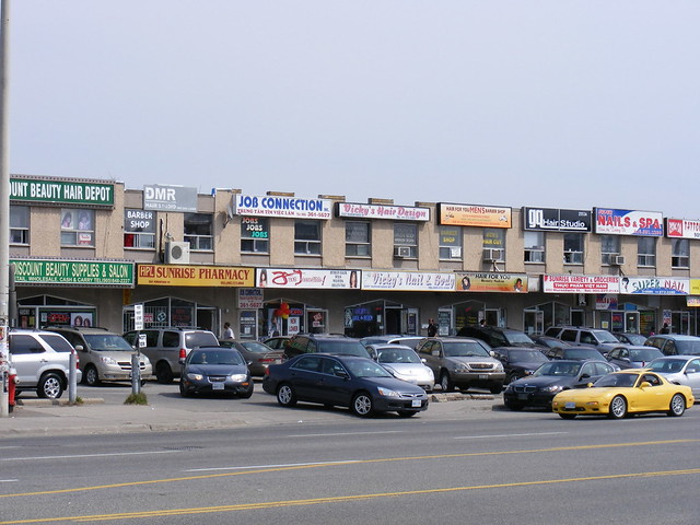 1960s strip plazas thrive, but this one has a disproportionate number of hair and nail salons


7 comments
Great read! I always knew there was a long history attached to Dundas Street but didn’t have the details until now. Some historic photos of old Cooksville would have been great.
Thank you for getting the Dundas street history correct. Normally it’s noted as “the road to Dundas” even though it’s much older than that city.
R
You should do an article on the huge number of store-front churches on Wilson in Downsview between Keele and Bathurst.
A big part of Cooksville’s stagnation is the fractured property ownership situation. One person owns a significant proportion of the key properties and buildings, while many of the strip malls are condominiums that do not lend themselves to shared action. This in turn has meant Cooksville continues to function without a BIA, whereas most of the other successful subcentres in Mississauga (and Toronto), including Port Credit, Streetsville, and Clarkson, benefit from very active BIAs. The City is not interested in picking up the slack if there is no leadership from within the business community.
Not only was Dundas Street built far from the lake for military reasons, but it follows a natural ridge (at least for a significant portion of its route through Toronto’s west end). From what I know of local history, Dundas Street incorporated an existing aboriginal road. I’ve always wanted to know more about this; it fascinates me that this road I’ve lived on or near for many years has been a thoroughfare for centuries.
I’ve made the mistake about Dundas Street’s naming origins in the past, so that’s something I wanted to be sure about this time before posting. I also have a strong sense that the path pre-dates European settlement (there are several streets in Toronto that are for sure, such as Davenport Road), but was not sure about Dundas, but is the most logical explanation. The Queenston Road/Highway 8 between Hamilton (as King Street) all the way to the Niagara River certainly was a former aboriginal trail, and follows the old lakeshore just below the escarpment.
Most of Dundas Street is quite straight, but there are areas where I wonder about its historical route:
– What route did Dundas Street take between Dundas and Waterdown? My sense is that it climbed the escarpment via York Road to head east to Toronto.
– Did the original Dundas Street go straight all the way to London originally, or did it follow the South Thames River west of Woodstock? (via the existing county road through Beachville/Ingersoll, which enters downtown London as Hamilton Road). What I do know is that the original Dundas Street west of Dundas is known as Governor’s Road/Highway 99/Highway 5; and Highway 2 west of Paris, and is straight as possible until you get to that fork in the road just west of Woodstock.
Interesting stuff, Sean.
I think we can also assume that Portage Road in Niagara Falls was there long before Europeans as well 🙂