

In the wake of last week’s decision to continue to build-out Toronto’s LRT plans — and since Mayor Rob Ford continues to mistakenly call any LRT project a streetcar line — Spacing will profile a handful of LRT projects from around the world that will give readers a little better understanding of this transit option
![]()
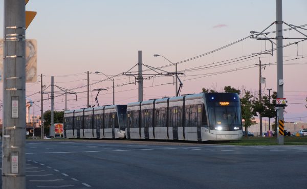
Stockholm’s subway stations are world renown for their artistic beauty, rivalling those of Moscow, Munich or London. Equally impressive is the Swedish capital’s LRT network, a major component of public transport for Scandinavia’s most populated urban area.
Stockholm’s trams go back to 1877 with the establishment of a horse-drawn line, electrified in 1901. The city’s subway began as a tram that went underground in 1933. In a bizarre turn of events, virtually every tram line in central Stockholm was abandoned as the result of Sweden’s switch to right-hand side traffic in 1967.
In 1991, Route 7, the Djurgårdslinjen LRT, was restored as a heritage tramway. Since then, two additional lines have been built and two modernized. Further, several lines are undergoing expansion.
Currently, Stockholm’s LRT network is composed of 4 lines with 53 stops stretching over 30 kilometres.

Route 7 is a combination inner city and heritage tramway route, inaugurated in 2010. Spårväg City is the first tram line integrated into regular traffic in central Stockholm since 1967. It is essentially an elongation of the Djurgårdslinjen (heritage tramway). The line is expanding east–west through the city centre and the new LRT route will replace some inner city bus routes.
Route 12 was one of the few lines that survived the abandonment of Stockholm’s tram system in 1967. Established in 1914, The Nockebybanan LRT continues to provide service to the western suburbs.
Route 21 the Lidingöbanan is actually a railroad, operated with trams as an interurban LRT route. It services the eastern suburbs.
Route 22 opened in 2000 and runs outside of central Stockholm, connecting adjacent municipalities, suburbs, and major transfer points. Known as the Tvärbanan (Crossways Line), this LRT carries over 40,000 passengers daily, projected to increase to 150,000 pending the completion of the eastern and northern extensions.
Photo by Hans Nerstu
13 comments
Um, other than saying they have four lines, what value does this bring to the discussion?
Love to see these kinds of examples!
To respond to Brian, it’s clear to me that this is an example of a city that has both a subway and an LRT system. Stockholm is quite comparable to Toronto in terms of population and size and even weather. The fact that they are building their own version of the Crosstown LRT (route 22) that “runs outside of central Stockholm, connecting adjacent municipalities, suburbs, and major transfer points” is what a post like this “rbings to the discussion.”
Can’t wait to see which other cities you choose to profile. Gotheburg Sweden?
@Brian, I think that it shows that other cities, yea, even those in a northern climate, do have a sensible mix of transit: it’s not just “people want subways” and that’s the only option. Note that 47,000 people a day use the Route 22, just under the number who currently use the Sheppard subway, which will be underutilized for decades to come, and require operational subsidies of tens of millions per year.
On the other hand, let’s put in an LRT at no cost to us (the City, of course the taxpayers pay), and down the road convert it to subway if needs be. That what happened with the Yonge and Bloor lines, which were oringially streetcars running in mixed traffic. A Sheppard LRT would not even be running in mixed traffic.
I’m with Brian. This doesn’t really tell me much or help the argument. We all know that there are cities, even big ones, with LRTs. The problem is that the Fordists trot out St. Clair, which is what Torontonians know. The TTC claims that “these ones will be different”, but people hear “median ROW” and think St. Clair (or don’t trust TTC to get it right, which may not be an unfounded fear).
This could be a really interesting and useful series if it focuses less on the “where” and more on the “what” and “how” — as in, what does the design look like, how does it operate (speed, traffic signals, stop spacing, frequency, etc.), and are there any sections where the design and operations are comparable to what Toronto is planning to build? Links to Street View sections? Links to YouTube videos (especially the LRV driver perspective)? What kind of transit priority measures do they use and how do they make them work? If it was recently built, did they need to get around a “war on car” mentality like here?
Brian, what’s wrong with St Clair?
Brent, rather.
Brent: Tvärbanan, which is really the flagship of Stockholm’s tramways, combines just about all modes of operation. At its east end, a nice new-build waterfront suburb on former port lands, it runs in the median (this is the area shown in the photograph). Much of the rest is on a largely separated line, where the experience is very similar to riding the metro. There’s also a bit of mixed-traffic running in the Liljeholmen area (which doesn’t seem to impact speed very much), and Stockholm’s geography makes the occasional bridge or tunnel inevitable. The new extension follows similar principles, involving a new tunnel, some on-street track around Sundbyberg, and taking over an old railway.
The City line runs in the median and bus lanes the whole way, though it’s a much slower line, with frequent stops and more interaction with road traffic. The remaining two are run much like low-end railways, with their own tracks that don’t particularly follow a road, but level crossings here and there. The next stage will be to build tracks along the eastern edge of the city to link line 7 to line 21 (which is the only line not yet using modern low-floor trams).
There has been substantial argument over trams vs. metro extensions, though tempers don’t usually get as heated as in Toronto, and neither side wants to defend the car. And there’s a reasonable awareness that Tvärbanan has taken pressure off the metro by allowing suburb-to-suburb trips to bypass the city centre (the area around the western end of line 7). Oddly, in Stockholm it’s the left wing who keep arguing for ‘just one more subway’, while the right advance a plan for trams to eventually cover the entire city.
Stockholm is a much smaller city than Toronto. It is similar in size to Vancouver. Solutions that work in a metro area of 2 million do not necessarily work in a metro area of 5.5 million.
I love the idea here, but I agree with Brent: More details would be very much appreciated. The routes are not as valuable as a description of the experience would be.
Thanks, David, for all the details you added!
Dave, Brian & others: Check out the post that went up Wednesday about Melbourne’s LRT. I think that might be what you’re looking for.
https://spacing.ca/toronto/2012/02/15/lrt-today-worlds-largest-tram-network-in-melbourne/
John,
while I cannot speak for Brent, here is what I think is wrong with St. Clair: too many stops, no real signal priority, not consistently far-side stop, and generally too slow. It is built as a Spadina-style streetcar, instead of LRT. As such TTC missed a great opportunity to showcase modern LRT to Torontonians. Instead it becomes a perfect vehicle for the opposition of LRT to spread mis-information about LRT.
I had said this before on this forum and was rebuked with the argument that St. Clair is different, it is a main street with lots of local businesses that requires a streetcar instead of LRT. But would it really hurt if the stops are 500-600 meters apart instead of 250? Is it that hard to require people to walk 150 meters more to those shops? How would signal priority hurt anyway? BTW Eglinton West is not much different from St Clair, so why is LRT considered OK there? I am pretty sure some of those modern LRT lines in other cities run through vibrant commercial streets, what damage have them done to the those streets?
I know that the decision about the stop spacing was made based on public consultation. Of course every business owner on the stretch wanted a stop right in front of his shop. But if you try to satisfy them all, what you get is sub-optimal to everybody.
Yu, you write: “would it really hurt if the stops are 500-600 meters apart instead of 250?”
Answer: yes. St. Clair swrves the local communities it passes through. It is not a commuter route and thus does not need LRT. There are lots of churches along St Clair and the area serves an older demographic than most TO neighbourhoods.
You also wrote: “Eglinton West is not much different from St Clair, so why is LRT considered OK there?”
Answer: Eglinton W is about 33% less wide than St Clair. It cannot accommodate more than 1.5 cars lanes if LRT is above ground along Eglinton West. Eglinton Ave, except for 5km in the middle of town, is an arterial road. St Clair isn’t like that. Eglinton is a much different beast than St Clair.
Lastly, you wrote: “I know that the decision about the stop spacing was made based on public consultation. Of course every business owner on the stretch wanted a stop right in front of his shop. But if you try to satisfy them all, what you get is sub-optimal to everybody.”
Answer: II asked for short atop spacing as a resident of the street. And so did almost every other resident who took part in the consultation. And so did the businesses. So did the developers. So did the councillors. Why? Because the line is not a commuter line.
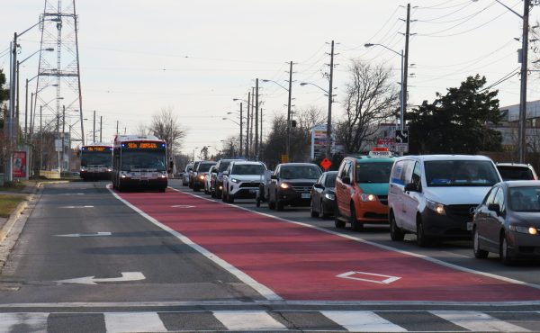
Your desire for suburan-style LRT exists in Toronto on the Queensway between Roncesvalles and Humber Loop — it is low-density and has wide stop-spacing. 4 lanes of traffic 2 lanes of streetcar. Looks good, runs quickly until it runs into traffic in the density of Queen West.
This is what the original Transit City plan is supposed to look like. LRT vehicles in their own right-of-way, stations that dont require stairs or elevators, etc… I wonder if Mr Ford has actually seen a photo like the one above or is he showing his surface transit phobia again by not look at LRT images.