
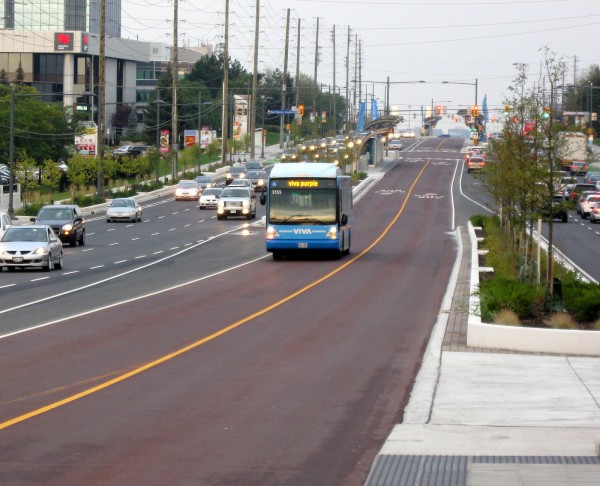
Viva Purple bus on new Highway 7 Rapidway
I recently visited the first completed section of “Rapidway”, York Region Transit’s moniker for its new median bus rapid transit (BRT) lanes. YRT’s planned network of Rapidways is intended to transform YRT’s backbone, Viva, into a true bus rapid transit system. Viva was introduced in 2005 as a separate brand, but integrated with, YRT, as a “BRT-lite” service, with conventional buses making limited stops in mixed traffic, with off-board fare payment and all-door boarding.
This first section opened in August, on Highway 7 between Bayview Avenue and East Beaver Creek Road on the Markham/Richmond Hill border. An eastern extension of the new busway on Highway 7 to Town Centre Boulevard (near Warden Avenue) is nearing completion. The primary service on this first phase is Viva Purple, which operates from York University to Markham-Stouffville Hospital. A rush-hour supplemental route, Viva Pink, operates between Finch Station and Unionville GO Station.
The Highway 7 Rapidway is part of a much larger “VivaNext” plan for building new rapid transit corridors and upgrading others across York Region. Rapidways are also under construction on Highway 7 in Vaughan near the terminus of the Spadina Subway extension, and on Davis Drive in Newmarket, which will see new Viva service in 2014. Further phases include Highway 7 and Centre Street in Vaughan and Yonge Street north from Highway 7 in Richmond Hill.
Interestingly, there were also plans for similar bus-only median lanes on Yonge Street south of Highway 7 all the way to Finch Station; this is the busiest of York Region’s transit corridors. However, York Region is lobbying for the extension of the Yonge Subway to Richmond Hill and has replaced the busway in its plans with the proposed subway extension.

Valleymede Vivastation
There are six new “Vivastations” (as Viva’s bus stops are branded) in service in this first section. At Bayview Avenue, buses load and unload at the curb. Going eastbound, buses cross three lanes of general traffic and enter red-paved bus-only lanes in the middle of Highway 7. Attractive glass canopies shelter waiting passengers at each station; shelters are heated in the winter. Fare payment is made at the station (Viva uses the proof-of-payment system, similar to GO trains), so boarding is fast and simple.
Traffic signals have the same basic operation as on St. Clair Avenue. Rapidway stations are usually on the far side of each intersection, providing room on the near side for left turn lanes. Each intersection has separate left-turn phases from Highway 7, buses proceed with the general through traffic phase. Pedestrians going to and from the Vivastations must cross with the lights at the designated crosswalks.
There is much to like about the new Rapidways, but there are several downsides, particularly for pedestrians. And the ugly truth is that while York Region builds impressive transit infrastructure, transit service remains neglected.
Highway 7 is urbanizing though Markham and Richmond Hill
The good
There are many good things about the new Rapidways. The stations are attractive and well-designed. During construction on Highway 7, York Region improved the streetscaping, including improved sidewalks as well as flowerbeds and many newly-planted trees. Hopefully these improvements are maintained over the long term.
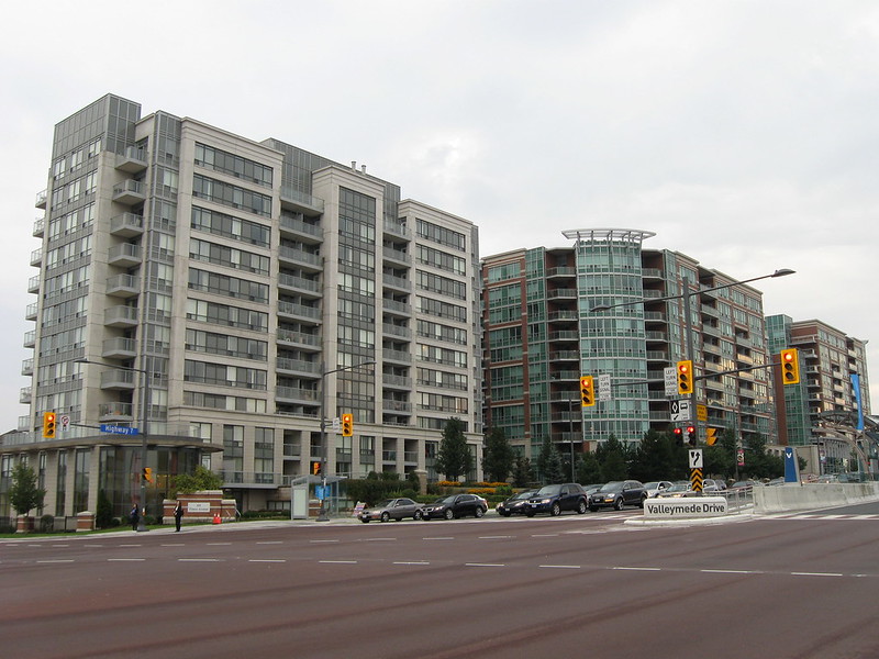
Highway 7 through parts of Richmond Hill and Markham have urbanized over the last decade; mid-rise and high-rise condominium towers, many of which have successful streetfront retail. There appears to be a deliberate effort to direct high-density development to these transit corridors. Many of the renderings on the VivaNext website illustrate those plans.
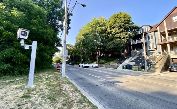
Where the Rapidway has opened, York Region also built new bicycle lanes and lowered speed limits from 70 and 80 kilometres an hour down to 60 km/h. The bike lanes are not separated from the busy car and truck traffic on the corridor, but a narrow painted buffer was added, giving cyclists a bit more room. Near intersections, the bike lanes are painted green, while green-painted boxes guide cyclists to make indirect two-stage left turns. These boxes, shown below, allow cyclists to avoid crossing three lanes of busy traffic to reach the left turn lanes. 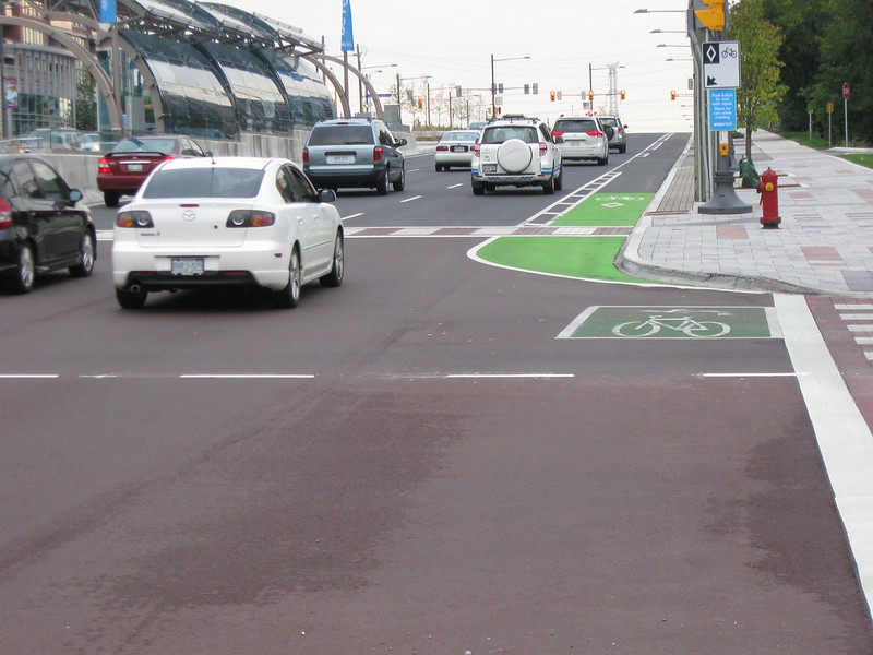
New bicycle lane and left-turn box at Highway 7 and Valleymede Drive.
The bad
While Highway 7 itself is now a bit more pedestrian-friendly, it’s a different story when having to cross it. York Region widened Highway 7 to accommodate the two bus-only centre lanes while maintaining six through traffic lanes (three in each direction). Therefore, in order to cross Highway 7, pedestrians must traverse seven traffic lanes (includes the left-turn lane), two bus lanes and two bike lanes. Unlike Spadina or St. Clair Avenues, which also have transit medians, pedestrians must cross Highway 7 in two separate phases; the countdown timers are too short to cross all at once. Pedestrians must wait between lights in the median at the entrance to the station. Walk signals are not automatic for crossing Highway 7; the button must be pressed a second time to get all the way across.
Local services, such as the parallel #1 Highway 7 bus, do not serve the bus median but load from conventional stops on the curb, on the near-side of each intersection, making it difficult to transfer from the express Viva service to the local YRT service. Short trips that could utilize either the local or Viva bus requires the passenger to choose which bus to catch, rather than wait in one general area and board the first bus that appears.
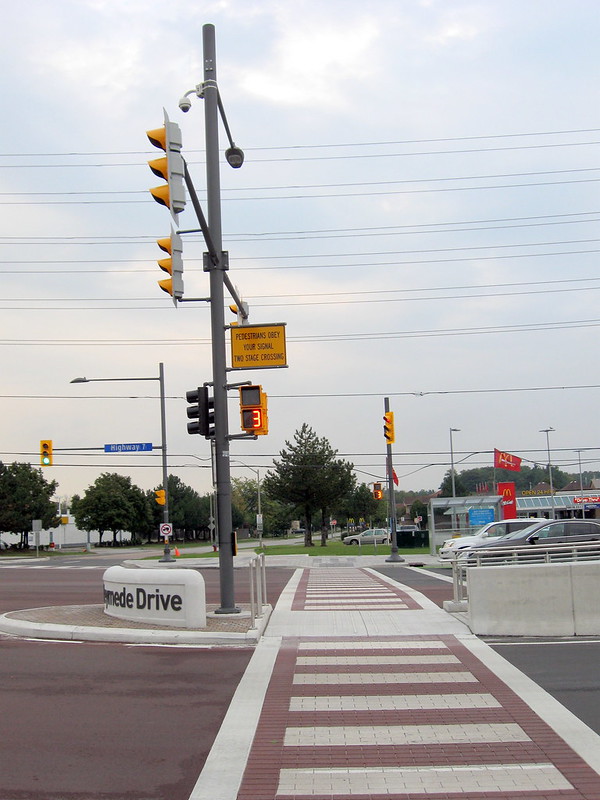
Two-phase pedestrian crossing across seven traffic lanes, two bus lanes and two bike lanes. Note the local bus stop and shelter on the far side of the intersection.
The ugly
While York Region has been busy building the fancy new BRT infrastructure, the rest of the bus network that feeds into the Viva spine is largely neglected. YRT has cut service levels on many of its routes each year since 2010; the 2014 service plan (PDF) proposes more service reductions. A lengthy strike by YRT’s private contractors over three months in 2011-2012 affected most of the system. Meanwhile YRT’s fares are the highest in the Greater Toronto Area; in fact there’s a proposal to hike one-zone cash fares from $3.75 to $4.00 in early 2014 and make similar increases to the cost of other fare media. (In comparison, TTC cash fares are currently $3.00, tokens are $2.60 each.)
Even on the fancy new Rapidway, service levels almost make a mockery of the fine new infrastructure. On this portion of Highway 7, buses are scheduled every 16 minutes off-peak, this improves to a bus every 8 minutes during the peak hours. The TTC has several dozen routes – operating in mixed traffic – that see better service. Incredibly, the 2014 service plan proposes cutting some late evening trips cut from Viva Purple, the only off-peak service on the new busway.
With further intensification and attractiveness of a faster, more comfortable commute by bus, I’m hopeful that York Region’s trend of cost-cutting will reverse itself and that these attractive new Rapidways will prove their worth. In the short term, however, it is hard not to feel a bit skeptical.
12 comments
Unprotected bike lanes, fancy bus lanes that only feature a bus every 16 minutes….
In a word, crappy.
How do pedestrians board the buses stopping in the far lane? Do the buses have doors on both sides or do pedestrians have to cross in front of the bus and then board from the far side? Considering how little space there is between the bus lane and the turning lane, that seems far too dangerous.
Basshat: The stations are in the median, on the far side stop of each intersection; the stops are positioned almost exactly the same way as the streetcar stops in the median right-of-ways on St. Clair and Spadina (the second photograph shows where the bus boards) Eastbound stops are on the east side of the intersection, westbound stops on the west side. Pedestrians must cross part of Highway 7, using the crosswalk, to reach each station. Once there, they board the bus using conventional curb-side doors.
Well, on the plus side, they got the hard part out of the way: they got money and they managed to build the darn thing.
It may be underused, but at least it’s there. Yes, YRT needs to change its operational culture and that’s not going to be easy, but when they do have a change of mind at least they don’t have to go looking for money or wait for shovels.
I have a bit concern with the station design. With the infrequent buses some riders may have a strong urge to cross against signal to catch a bus. Now, jay walking on Hwy7 is totally a different ball game than on St. Clair or Spadina. Hope this scenario does not turn into reality.
A couple of things I’d like to point out:
1. While “technically” you are supposed to cross in two stages, the countdown timers provide ample amounts of time to cross in a single phase.
2. While the stops are on the far side, transit priority (at least when I tried it) is set very high, so rarely are you stopped for more than a few moments before crossing. In fact in most cases, lights will turn green as the bus approaches.
Besides that, you seem to hit all the right points. Especially regarding reducing service and fare increases.
York region took the easy way out by widening its already harsh arterials where space was available.York Region’s 2010 road construction program identified that ‘numerous roads … have a potential of being widened to 6 lane cross-sections by 2020′. To provide a green halo to these widenings YR required any ‘street widening to 6 lanes must incorporate dedicated Transit’, HOV lanes and bike lanes..’
Transportation chose its locations based on land availability and current & expected vehicle congestion. It’s hard to take York region seriously when the vast majority of York region’s ‘main street’ highway 7 doesn’t even have sidewalks. Even ‘downtown Markham’ (e.x. in front of the Markham Civic Centre).
If support for providing transit doesn’t improve in York expect increasing congestion. Stalled vehicles on Hwy 7 will jealously eye the underused pavement, eventually pushing Markham pols to fight for some dubious ‘transit improvement’ (subway, LRT etc) that would allow the lanes to revert to drivers. Others will propose more efficient utilization by adding HOV traffic, taxis, HOT lanes, electric vehicles or some other trojan horse.
Roger:
“. Stalled vehicles on Hwy 7 will jealously eye the underused pavement, eventually pushing Markham pols to fight for some dubious ‘transit improvement’ (subway, LRT etc) that would allow the lanes to revert to drivers. ”
I’m not so sure of that. I’ve never seen an urban arterial in North America that was 8 lanes (4 in each direction) wide consistently for kilometers. 6 lanes seems to be the maximum everywhere, including in the most sprawly of the big sunbelt cities. I think that beyond 3 lanes there are diminishing marginal returns on the amount of traffic that can be pushed through. Someone in the right or left-most lane would have to move over 3 lanes to make a right or left turn; something that would happen with increasing frequency in a wide road and cause many tie-ups. If nobody else does, I think that municipal traffic engineers would put a nix to that idea pretty quickly.
“I’m not so sure of that. I’ve never seen an urban arterial in North America that was 8 lanes”
I was suggesting that stalled drivers would eye the usually empty bus lanes and would lobby politicians for some type of above or below grade transit option either under hwy 7 or that would serve the corridor demand to some extent, (e.g. 407 corridor or a line heading north to downtown Markham for ex. The line would essentially be sold as a hwy 7 relief line for drivers who would then take over the then unused bus lanes.
While a highway 7 subway or skytrain etc may be financially insane (like Vaughan Metro Ctr, STC & Sheppard) subways are doled out to address the political demands of frustrated suburban motorists (& developers) rather than addressing the needs of transit riders who are a minority in the politically crucial 905.
One thing to note:
York Region took away most dedicated right turn lanes on Hwy 7 onto other north/south streets in order to create the bus lanes. What that amounts to is a lot more congestion in the 2 right lanes because people have to slow down in an active lane to turn right. Congestion = more gas wasted = more emissions/greenhouse gases.
The real concern for passengers between 6-9am and 4-6pm is the commute
downtown to Finch station. I lived in York Region over a year ago and
let me tell you that the stretch from Hwy 7 to Steeles along Yonge is some of the
slowest, most congested transit I have ever ridden in the world. It takes about half
an hour or much more often in rush hour to get from Richmond Hill Centre to
Finch. The dedicated bus lane (that occurs between Finch and Steeles should
extend all the way to Richmond Hill, period. If you want to make a subway line
there someday start with a bus zone like they have here on Hwy 7 east/west.
It seems unfortunately that the set up for Yonge Street is to have lots
of stoplights and access to strip malls (fine for people who aren’t
commuting downtown). This is one of the reasons I find it hard to ever
want to move back to the GTA ever again.
Steven, just wait until the World on Yonge complex — four residential towers (20-30 storeys), shopping (including the Galleria 24-hour Korean supermarket), hotel, office building — begins to come online shortly on Yonge not far north of Steeles. On the stretch you are talking about, you ain’t seen nothing yet! So much more transit is needed there.