
With this post, Spacing Toronto welcomes a new contributor, Shoshanna Saxe. Shoshanna is a proud Torontonian and a civil engineer. From 2009 to 2012 she worked on the design of four forthcoming transit stations in Toronto. Shoshanna is currently working on a PhD at the University of Cambridge researching subways. She will be writing about transport and transport infrastructure. @shoshannasaxe
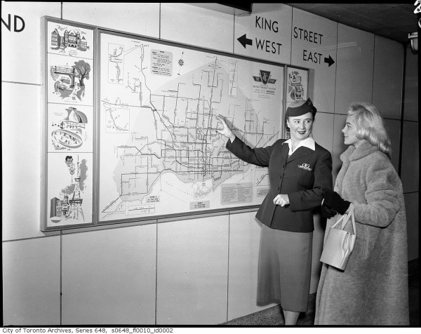
The first segment of the Toronto Subway opened to great fanfare on March 30 1954; the original Yonge Line had 12 stops running from Union to Eglinton. Two decades later, these stations consistently showed up in academic literature as the best-planned in North America. Toronto was world-renowned for its transit system and had the highest transit ridership in the continent. What made the Toronto subway successful?
Ideally, subways and local development create a positive feedback loop: the construction of new subway stations provides an incentive for development nearby which, in turn, contribute to the success of the subway system and to the finances of the city that built it. This relationship between subways and development has always been one of the selling points used to promote subway projects.
By the 1970s it was clear from the experience in other cities that promised development didn’t always appear and that Toronto had been more successful than most in linking transit and development. Constructing transit stations, it turned out, was not enough by itself to spur new development and achieve high ridership.
In a seminal study from 1977, “Land Use Impacts of Rapid Transit”, the San Francisco engineers Robert Knight and Lisa Trygg found that successful subway stations were supported by aggressive public policy in the form of zoning and development incentives. Toronto was held up as a best-case scenario of what it is possible to achieve with careful investment, design and policy.
The TTC has studied (PDF) the neighbourhood density requirements that lead to well-used stations. To be economically successful, as defined by the TTC, stations need to have a density of 100 people or jobs per hectare within 500 meters. For the Yonge Line, still Toronto’s busiest, much of its density comes from buildings built in the 1950s. From 1952 to 1962 more that 90% of all office construction in Toronto was built within 5 minutes of Yonge Street and its subway. Half of all new apartments built between 1954 and 1984 were sited walking distance from a subway station. In the first decade of operation the subway was responsible for a $10 billion (1968 dollars) appreciation in land value along Yonge Street.

In some ways Toronto got lucky: the opening of the subway coincided with an era of rapid urban development across Canada; however, the development near subways was not just luck. Toronto’s government made use of deliberate policy initiatives to attract the development to the subway corridor.
In concert with the initial construction of the Yonge Line, the Metropolitan Toronto Government changed nearby zoning to allow for 12 to 1 floor area to footprint ratios (FAR) and awarded density bonuses. The subway started by providing much-needed access to the central business district. Government buildings were built near the subway to demonstrate public faith in the system, which inspired private developers to follow suit. Stations were sited beside plots of land, such as underused industrial yards, that were available for development. In addition, costs to developers were actively limited; long term leases were made available on publically owned land near stations removing the expense of land purchase. Even the structure of the stations were designed and constructed to facilitate construction of tall heavy buildings nearby; the strength of the subway structure limited the need for expensive foundation work in new buildings. The bus system was aggressively integrated into the subway system to facilitate seamless connections and ease of use.
Moreover, the city followed through on promised projects, allowing developers to have confidence in them. In 1966, the metropolitan planning department recommended that Toronto build 59.5 km of subway by 1980. Toronto exceeded this goal—by 1980 it had 63 km of subway operational or under construction.
The legacy of this early planning success continues to be visible in Toronto, even outside the downtown core. As the Yonge-University-Spadina Line was extended, similar development-centric polices contributed to the success of the Sheppard Centre and Yorkdale Shopping Centre. The vitality of Toronto through the second half of the 20th century is often linked to the success of the city’s transit system.
In 1986, when writing about the great success of Toronto’s and other Canadian city’s transit systems, the famed urban planner Robert Cervero noted: “Whether Canada is light-years ahead of most other nations will perhaps best be determined by future transportation historians. Regardless, it presently offers a gold mine of fresh ideas and insights in the transit field that should not be over looked.”
The current Toronto Subway has 68 operational km, slightly more than in the 1980s. Over the past 25 years the system has been expanded twice. Downsview Station extended the Yonge-University-Spadina line by 2 km when it opened in 1996. The 5.5 km Sheppard Line followed in 2002. As the TTC moved away from system expansion Toronto’s reputation as a transit leader faded.

7 comments
Thank you for this. I always hear how the Toronto transit system was renowned at one time in the past but have never actually looked in to it. This is a great summary.
Anything new is great. Then it gets old.
There’s the second chapter of this story that is missing. And that helps explain more clearly the links between subways and development.
The second subway line – Bloor – Danforth – did not create the same pattern of development that the Yonge line did. For the simple reason that the neighbourhoods along that line opposed development. City Hall listened to the voters. When I arrived in Toronto in 1988, I was of course taken up the CN tower and shown the pattern of high rises along Yonge at each subway stop. But that was not visible along the east west line at all.
“Anything new is great. Then it gets old.”
just like us…
There is nothing particularly “wrong” with the Bloor-Danforth line which manages to be full in spite of the (mainly) preserved low rise neighbourhoods around it.
There was already a busy streetcar line on Bloor-Danforth fed both by walk-in trade and by buses from what we now call the “inner suburbs”, and this pattern expanded as the line extended into Etobicoke and Scarborough.
It is worth noting that it is the concentration of jobs, particularly in the core, that generates demand on the subway and less so the population around its stations. Finch Station does not depend on walk in traffic, but on floods of buses carrying riders from afar.
The station-as-predictor-of-demand model is deeply flawed, but it is part of the Toronto mythology.
The TTC was easily the best-run transit system in North America from about 1922 to 1972. Thus Toronto managed to get through the crisis that destroyed so many U.S. systems, and the ups and downs of wartime, with a high level of reliable service – and no operating deficit. The dates on either end of this 50-year streak are significant. The TTC came under municipal control in 1922, one of the first publicly-owned transit systems on the continent, the essential key to surviving the next three decades unscathed. And until the end of 1972, a single TTC fare would take you anywhere within the compact, pre-WW2 urban zone but *not* into the postwar suburbs. Not to say that suburbia shouldn’t be served, but that it makes things a lot more difficult for transit operations and planning.
Building subway lines along the major transport axes of the pre-WW2 city was an easy right decision, especially when accompanied by enlightened policy choices as the article points out. Going beyond that, transit planning in Toronto foundered. The initial success of the inner-city subway has also left a perception that only the subway is good enough, even when extending into low-density suburbs along secondary arterials. Yet there is plenty of need for transit lines that are faster and more capacious than bus service without being full-blown subways. Another problem has been cooperation and integration with regional rail (GO). After the convulsions of the recent past, perhaps things might advance with a bit more clarity now?
If judicious development planning is part and parcel of transit planning, then in many cases the evonomic benefits of rapid transit can be realized. The problem occurs when the line is built because of the dream of (or promise of) new development or significant passenger numbers…and those numbers are simply not realized for whatever reason.
The interesting thing here is that Line 1 and Line 2 can both be extended from each of their terminals to areas that provide a great opportunity to redevelop and redesign the communities the would serve.
In Toronto, City Planning is already talkung about rezoning the McCowan precinct in the east end, while the 6-Points interchange redesign and development of abandoned/underused land along Dundas St in Etobicoke will be starting very soon. Perhaps we will see an extension of Line 2 westwards to a terminal south of Cloverdale Mall start construction before my 3 year old attends university.
Vaughan already has their Vaughan Metropolitan Centre plans at the north end of Line 1, and development along the Yonge St corridor at the other end will present an opportunity too.
The problem is if we think we can import a model that has proven effective in other areas (like the rail+property model from Hong Kong or the overarching transport authority from London) without realizing that such a model will have to be adapted to Toronto’s own situation…and that this adaptation is a long and tiring process.
Cheers, Moaz