
The Toronto Streetcar, older or newer type, is an ever-present symbol of the city. The red, black and white TTC colours trundle along century old tracks, east and west, north and south and are a crucial part of the city’s fabric: 56 million trips were made by Streetcar in 2017.
On one street, famous to Torontonians, streetcar ridership has jumped 17 per cent. And what is happening there for a meagre $1.5 million in urban design tweaking, offers us a potential model for the city as a whole.
King Street pilot goes permanent
The King Street pilot effectively banned through-traffic for two-and-a-half kilometres of King Street along 13 downtown blocks from Bathurst to Jarvis. Deliveries and services who need vehicle access still can use the street; they just can’t use it as a through-route. It’s all achieved by road signs, some signal changes and changes to road markings, all cheap and quickly reversible if the City changed its mind. But it didn’t. On April 16th 2019, Toronto city councillors voted to make the changes permanent. Here’s why.
1. Transit is better
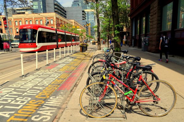
By filtering out the main competitor for space and capacity, streetcar journeys became quicker and more reliable. And streetcar ridership is ticking-up as a result: the City’s data reports a third more riders in the morning peak and 44 per cent more riders in the evening peak. On an average day 84,000 trips now take place on the route.
2. Public space is better
Parking bays along the route have been quickly and cheaply made in to miniature public spaces or parklets. 18 have been created in total, making the street a more pleasant place to spend time, and creating a buffer between moving vehicles and the sidewalk.
Compared to many European cities, Toronto’s downtown is really starved for public space. The parklets are an absolutely welcome addition: somewhere to sit and rest, take a lunch-break or socialize. Some of the spaces are even programmed with activities or artworks. It’s not always about moving people but providing somewhere to go. The more Torontonians get used to this kind of thing, the more they’ll want.
3. Cycling is better
A street with fewer cars is a safer, more pleasant place to cycle. It’s now the second most popular street for cycling in Toronto after the cycle tracks on the parallel Richmond-Adelaide corridor. Cycling numbers are nearly double what they were before the changes (an increase of 190 per cent, according to the city’s counts). That said, sharing a street with streetcars and their tracks is by no means inclusive cycling infrastructure, but it is still a major improvement.
4. What about traffic?
Clearly vehicles numbers dropped significantly on one street, but the dispersal to other streets hasn’t been as feared. Journey times for cars on parallel routes have barely changed: plus or minus a minute here and there, states the City’s monitoring. People who used to drive along King have likely changed in step with the infrastructure; we choose different routes, times, modes, a mix of these, or simply stay put. It became a little harder to drive along a short section of King, but its public space, transit and cycling options got a lot better. For any modern city planner, this would count as a success.
What next for King?
The cheap and cheerful makeover will now get a little more money to smarten it up. The City has set-aside $1.5 million to make some of the pilot features permanent. That means those built-out streetcar stops will be made a more accessible part of the sidewalk. Permanent policy needs to look permanent on the street too.
1. Protecting the public
In an age of ‘hostile vehicle mitigation’, as the UK’s Centre for the Protection of National Infrastructure calls it, there is greater urgency to protect people from vehicles. The parklets and public spaces on King ought to have more robust materials to do this. Riding the 504 on a Sunday in April, I witnessed a driver crash into the planters, knocking two people over in the process. Defensive materials can be subtle or not so subtle, but either way, they are important. With a Vision Zero approach in place, we should accept that people make mistakes behind the wheel and therefore people outside cars need as much physical protection as those inside.
2. Extending to more of King and Toronto
With the rapid growth of Liberty Village and other places along King, the 504 is in demand. Extending transit priority further would, of course, be worth looking into. On King, extending it west to Dufferin may give some respite to the sufferin bus (the city’s fourth busiest) as people opt for a quicker, more reliable street car over riding the 29 to the subway.
Other streets in Toronto would definitely benefit from this. LRTs like the Eglinton Crosstown are essentially a much more heavier infrastructure version. But a glance at the busiest bus and street car routes in the city gives you an idea of where could be next – 501, 506, Finch, Lawrence etc.. The City can also use transit priority to increase ridership on strategic routes in areas of low incomes, poor accessibility. Improving them, not because there is existing demand, but because that demand is suppressed by congestion, poor reliability or infrequent service.
These approaches are common in Europe. In London, a major transport priority project is underway to expedite the big red London bus, create new public space and build cycle tracks (sound familiar?). The entirety of Cambridge’s core is transit only while in Germany, Freiburg’s spinal streets are streetcar and pedestrian only and many French cities clear their streets of cars to put trams in.
With the pilot we have proof of concept. Now is the time to start rolling out to other key corridors in the city.
3. Private sector contributions
I’d like to see Canadian cities secure more meaningful contributions from developers to this sort of infrastructure. I’d also like the City to get tougher on restricting on parking garages in accessible locations.
For example, Liberty Village is growing rapidly. New condos are rising. The area is a fifteen-minute bike ride to downtown, sandwiched between the Exhibition GO station to the south and the King Street 504 to the north. To the west, it has the sufferin bus. It is one of the most accessible locations in the city. And yet there are four story basement car parks buried beneath the towers. Those deep basements add to the cost of construction and maintenance for floor space that could have more value in a city fighting a housing crisis.
Transport infrastructure is like water, broadband access, health facilities: a core part of what enables growth and enables house-builders to sell those homes. Those profiting from growth should contribute to the infrastructure that enables it.
4. Improving cycling
While taking out through traffic has been a huge improvement for cycling, there are still streetcars and their tracks to contend with. One could accept that the parallel Richmond-Adelaide streets provide the main through cycling corridor. However, people riding still need safe infrastructure to get to all the destinations along King Street itself. Cycle tracks could be installed in a number of ways. You might need a sliver of the public space formed from old parking bays. Tacks might then be raised through street car stops (like Roncesvalles) or bypassed around the back of a waiting area (like London and Copenhagen). And, even without any of the above, cycle priority signals could be installed. Ensuring people riding get separate green lights to go ahead of other vehicles, or separately altogether, while people turning right are held at a red light.
These changes aside, there are valuable lessons to learn from the King Street Pilot.
What does the King Street pilot teach us?
1. Prioritise our streets
With a finite amount of street space, something has to give to make the other thing significantly better. And a strategic approach to Toronto’s streets would involve mapping out exactly which modes should have priority where, and developing our street plans accordingly. As far as I know, King is the only street to have benefited from this approach.
The 504 gets priority on King, while on Richmond and Adelaide nearby, through-movement (both cars and people on bikes) gets priority.
The small changes to King Street that boosted reliability, journey times and ridership for the humble street car need repeating elsewhere.
So while subway projects move along (or don’t), the City and TTC can get on with improving transportation at street level. A little less space for cars can unlock huge suppressed demand for walking, cycling, transit and outdoor public space. It’s time for the City of Toronto to agree on what it wants from its streets and invest accordingly.
2. Pilots have value
As a professional, I’ve stood on street corners and talked to people how their streets could change. The most common replies are that it’ll never work: traffic will displace, congestion will get worse, “you’ll never get me on a bike”. Pilots are the perfect counter. For cities, pilots allow us to test an idea, before tweaking and improving it, or even scrapping it all together. For the public, pilots help us to experience something different and, hopefully, beneficial. While pilots aren’t always be possible for technical reasons, they are a hugely helpful tool for planners.
Elsewhere pilots have been used to great effect. In New York, led by Jannette Sadik-Khan, the City famously painted the floor, put out temporary cones and bought up the City’s entire stock of deck chairs to create a pedestrian plaza on Time Square. Closer to home, we have the Richmond-Adelaide cycletracks in downtown Toronto. Pilots like these are a relatively quick and cheap way to demonstrate a concept and inform better decision-making of a permanent scheme (if it’s worth it).
3. Meaningful engagement matters
The level of engagement from the City with interest groups and communities on the King pilot has gone above and beyond most street projects, as has the monitoring effort with it. The fact that king works so well for the majority of the people that use it is a testament to this engagement and the robust data collection that has informed this engagement.
Lectures, emails, rider outreach, focus groups, group walks, interviews, surveys, public meetings and a stakeholder advisory group all provided meaningful opportunities to influence the project and gain local insights. A combination of online and offline engagement has allowed people to shape the project from the outset. A meaningful contribution leads to broader and deeper support, even vocal advocates.
If we want to move toward a more liveable city, one that moves people safely and efficiently, without the carbon emissions, road danger and isolating effect of cars, then more transit corridors, like King, are needed. The City ought to be expanding the existing schemes to improve the transit network and looking at other corridors where transit is becoming overcrowded, or where its underused but highly needed. The King Transit pilot shows that we can improve our streets with only minor tweaks and changes in design; that piloting and iteration – something the digital sector is very proud of – is valuable in city building, too. And that through deeper engagement we can build better schemes and support and advocacy for them.
After decades of car dominance, Toronto’s streets might just be on the cusp of a civic renaissance.
Nick is an independent policy and communications consultant from the UK, currently working out of Toronto, specializing in transport and environment issues. Follow him on Twitter @Nicholas_I_S
Find out more at: nicksanderson.co.uk
7 comments
It’s been a while since I’ve taken a stroll down a stretch of King street, but are their areas of old parking spaces that have been turned into patios for some of the restaurants and bars like they do in Montreal? While the parkets are good, perhaps they are more succesful in European cities becuase you can acutally sit and have a beer with friends. So dedicating the entirity of the leftover space to parklets is probably not the best way to activate the entirety of the corridor. A nice mix of patios and parklets would be ideal.
A natural first extension of the transitway would be to protect/prioritize the routing between the Dufferin Gate and Distillery loops. That’s really only a few kms in each direction
Wonder how much business the restaurants along King Street got when we had the Raptors parade? Especially when most of the streets were closed off to traffic.
Agreed! But I can’t see Mayor Tory having the cahones to establish more such lines. He already wanted to water down the King Street Crosstown significantly. We need another Jennifer Keesmaat to lead the way once again.
For those streetcar lines that aren’t yet converted, the city really needs to streetcar stops with pavement markings to indicate to speeding drivers that riders are boarding and alighting – “In an age of ‘hostile vehicle mitigation’, as the UK’s Centre for the Protection of National Infrastructure calls it, there is greater urgency to protect people from vehicles.” Road paint, like the city is already installing on bikelanes at bus stops, will make it intuitive to drivers that stops are danger zones. Drivers in this city are increasing aggressive and hostile to pedestrians.
The King St pilot is great for transit, and pretty good for pedestrians. I find it hard to count as an improvement for cyclists though. The seating areas in the former curb lanes extend really far out, so that cyclists are inches from deadly streetcar tracks. I wouldn’t risk it. Especially not with kids. It baffles me why the design couldn’t accommodate cyclists.
Pavement marking at streetcar stops is an excellent step to enhance Vision Zero 2.0. I suggest a Pilot at all major intersections (i.e. transit routes) . Furthermore, enforce this restriction with Traffic Wardens.
Overall it’s a huge improvement. I live and work in the King Spadina area. I don’t find traffic any worse in the wider area. As a pedestrian it’s definitely better. The restaurants in what was “restaurant row” have had it a bit tough. Partially I think it’s because that block is being squeezed to close and be redeveloped a a condo. If you go a couple of blocks further west, the restaurants and bars seem to be busier than ever, and have taken advantage of the expanded patio space.
Drivers still don’t understand the rules. I think they find the signage a bit cluttered and confusing. Hopefully that will be ironed out now that it’s permanent.
The addition of concrete blocks as barriers makes it all feel a bit like a street in Baghdad. The city needs to do something to make it look a little better. The stretch of King from Bathurst to University is a heavily travelled tourist area. It is really one of the main places where Toronto can make an impression. As a pedestrian, the streets and sitting areas are really dirty. It’s not very inviting. The city needs to follow through to really embrace what they’ve created. Replicating it elsewhere would be great, but they need to do it properly alll the way through.