In a city that loves to make, but not execute, plans and then overthink, but not solve, problems, there’s surely no better illustration of this twin-set of frustrating civic habits than the recently released 25-year Toronto Island Master Plan, which has done an absolutely masterful job of missing the proverbial forest for the trees.
The two-volume plan took four years to gestate, clocks in at 228 pages and has over 100 recommendations. It comes with numerous sidebars outlining engagement strategies, a “framework” document and a web of links to no fewer than nine other City strategies. The second volume concludes with a two-page appendix outlining all the various “ongoing studies,” “new studies” and “updates to existing studies” that will need to be completed in order to get all of us to the point when…we’ll need a new master plan.
You can spend several hours, like I did, trying to dog-paddle through all of it, seeking an answer to a question that no other grown-up city would force its residents to confront, which is this: will there ever be easier and less expensive — or even free, perish the thought! — ways to get to what is arguably Toronto’s pre-eminent public park?
All I can advise is, don’t wait up.
It is certainly important to acknowledge that Toronto Island is a complicated precinct, what with the Indigenous history, the Ward’s island community, a bunch of infrastructure, a superannuated amusement park, sandy beaches, flooding issues, erosion issues, etc., etc. There’s also a collection of constituencies that assert various claims to the Island’s spaces, some of which are premised on the maintenance of a degree of spatial exclusivity barely acknowledged in the Master Plan.
Mainly, it’s a large park in a rapidly expanding city where a growing proportion of residents don’t have backyards and cottages — a metropolis, what’s more, that fumbled the ball on building a major new public space (Rail Deck Park) and has lost access to another one (the bulk of Ontario Place) for, well, who knows how long.
The Master Plan, to be fair, does acknowledge that the Island has access issues, but the subtext all the way through this bewilderingly unfocused document is that the City doesn’t want to meaningfully expand the number of visitors. As the authors put it, the Island’s well-being demands “a light touch.”
The exact opposite is true of the visitor experience. The report notes that for the typical group travelling to the island, the cost to get there — $46 on average, for ferry tickets or water taxi, plus transit — is the single largest outlay they’ll make. There are no other cities which charge residents fees to visit major parks. It’s just not a thing.
The authors also conducted a largish online survey and found, unsurprisingly, that most visitors go there to get away from the city, socialize with friends and family or spend time outdoors. Yet a non-trivial proportion of those who took the survey also said it was difficult to get there or too expensive (44% in total).
The vast majority of the people who filled out the survey were already regular visitors to the Island — a self-selected minority. I suspect if the City had bothered to cast the net more broadly, it would have found that many more Torontonians never go because it’s just too complicated. This is an omission worth stressing: the City has no idea how many residents simply never visit. A lot, I’d bet.
The document, of course, repeats the now tread-worn promise about the imminent delivery of two larger, electric replacement ferries. (Two of the five ferries in the current fleet pre-date World War Two; one pre-dates World War One.) According to the latest staff report, which landed this week at the Infrastructure and Environment Committee, council has earmarked $83.4 million in its 10-year capital budget for these vessels, with the dollars coming over the next three years from a confection of debt, reserves and a ferry replacement fund that currently contains $8.6 million. According to the city, the ship-building contract will be tendered at some point this summer.
Yet there’s a distinctly Waiting-for-Godot like quality to the replacement ferry drama, which has been put-putting along for over a decade. The ten-year-capital budgets are subject to endless fidgeting, and a placeholder number that may appear in the latest cycle may well be gone next year or the year after. What is certain is the projected cost of the ferries only rises — from $11 million in 2015 to $63 million in 2022 to $83 million in 2024.
The ship delivery, what’s more, will require significant overhauls to the docks both at the foot of Bay Street and on the island, especially the Centre Island landing, and so we arrive at the fearsomely complicated riddle of carrying out major structural upgrades to the berths while attempting to maintain some vestige of service to and from the Island. The Master Plan is silent on this staging nightmare, made worse by the bottleneck that has long existed city-side. The City claims the project, which includes electric charging infrastructure, will take two years.
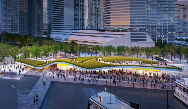
Parks, Forestry and Recreation has spent a bit of pocket change on the Jack Layton Ferry Terminal — there are efforts to improve the ticketing, for instance. The piece that’s gone completely AWOL, however, is the plan to completely redesign the notoriously utilitarian ferry terminal — an idea that became the subject of a high-minded design competition hosted a decade ago by Waterfront Toronto and which has since vanished into the ether. [Update: A Waterfront Toronto spokesperson says that “should full project funding be identified, the master plan concept selected through the previous design competition would be a starting point for revisiting the design.”]
Setting aside aesthetics, you’d think that the custodians of the Toronto Island might be contemplating contingency plans for maintaining access during the period when the dockside infrastructure is being re-built, but you’d be wrong.
Besides tacitly discouraging more visitors, the Master Plan’s few sentences devoted to the prospect of a pedestrian/cyclist-only fixed link — tunnel or bridge — across the Eastern Gap implies that such a “generational” undertaking is comparable in complexity to a moon shot. As a sidenote: at council last week, a member’s motion tabled by Don Valley East councillor Jon Burnside asks staff to report on the feasibility of such a connection, which many have advocated, most recently city council candidate April Engelberg.
There’s nothing especially complicated about this idea from an engineering or political point of view. After all, when Porter founder Robert Deluce wanted to connect Billy Bishop to the foot of Bathurst, he found ways to cajole the powers that be to build a tunnel under the Western Gap at a pace virtually unheard of in this city.
A permanent link at the east end makes abundantly good sense from a planning perspective, given all the population growth anticipated in coming years for the Port Lands, East Bayfront and the Lever Brothers site. Despite all that, the City’s parks mandarins — and the “stakeholder” groups that whisper in their ears — have prevailed with a schemata that prioritizes Toronto’s unkillable Toryism over the very real and specific needs of the contemporary city.
In the Master Plan, that priggish controlling impulse comes dressed up as environmental and Indigenous concern, wayfinding, programming, and all the other subtle ways that the City communicates its deep seated mistrust of Torontonians when they have the temerity to avail themselves of the city’s public spaces.
Next thing you know, they’ll even want to have fun.


5 comments
HEAR, HEAR, Mr. Lorinc. This provincial town needs an enema! So pathetic and not remotely world class or civilized.
The only place on the Eastern side of the island that a bridge could possibly terminate is the wet meadow. A designated environmentally sensitive area. It would destroy that habitat to drive thousands of people through there every day.
John
I enjoy your insight and knowledge about our city.
But your blind spot is your support about a bridge to the Island across the eastern gap.
You seem to have wasted your time dog paddling through the Toronto Island Master Plan.
If you had taken just a slight dive you might have found, this map
If you take a look at this map from the report you will see that the entire east end of the Island is an Environmentally Significant Area.
Your page will not allow the jpeg of the ESA Map.
Not only is it an Environmentally Significant Area it has Provincially Significant Wet Lands
Your page will not allow the jpeg of the PSW Map.
One would have to get the Environmental Laws changed, which would happen if only if Ford got enough money from his developer friends.
You would also have to overcome the resistance of the pro-environment community in Toronto.
The Toronto Field Naturalists, Bird Friendly City Toronto and the Toronto Ornithological Club all gave presentations at the Committee. They would be fierce foes of any encroachment on the ESAs or PSWs by your bridge.
You have not said a word about the active Port. Have you interviewed anyone in authority from Ports Toronto about having an active pedestrian and cycling bridge in the middle of a busy working Port?
Access to Port Property
7 No person shall access any area managed, held or occupied by a port authority unless
* (a) the person accesses the area to conduct legitimate business in the port;
* (b) the person is authorized by the port authority to access the area; or
* (c) access is not restricted by a sign, a device or in some other way such as by a fence.
* SOR/2004-255, s. 3
Port of Toronto Drives More Than $460 Million in Economic Activity
Toronto (November 6, 2023) – Marine cargo handled at the Port of Toronto generated $463.5 million in economic activity and 1,989 jobs in Ontario in 2022, details a new report – Economic Impacts of Marine Shipping in the Port of Toronto – published in September 2023 by Martin Associates.
The red outline is the working Port
Your page will not allow the map with the Port outlined.
Have you contemplated where the Port would move to and who would pay for the move ?
Do you know what the shippers and the cruise companies that use the port think of this proposal ?
And I am sure you know that the Eastern Gap is a navigable waterway as defined in law.
From Canadian Navigable Waters Act:
Works
Prohibition
Marginal note:
Works
3 Except in accordance with this Act, it is prohibited to construct, place, alter, rebuild, remove or decommission a work in, on, over, under, through or across any navigable water.
If your bridge is to be built, it either has to be one that opens to allow both commercial shipping and recreational boating through on a on demand basis, or it has to be 36.6 meters (120 ft.) above the surface of the water. If it is a solid bridge, the minimum distance from the top to the beginning or end at a 12-to-1 slope would be 439.2 meters (1,440 ft.) ; at an easier 20-to-1 slope it would be 720 meters (2,362 ft). It would need to be 3 or 4 meters wide or wider. I went over the pedestrian/cyclist bridge over the Lakeshore and Gardiner at Roncesvalles recently. That is maybe 3 meters wide.
Walking your bike (riding was not allowed), it was a squeeze meeting another person walking their bike.
Thinking of the distance from the city side to Ward’s beach, you are looking at a cyclist having to walk 2.4 kms from Cherry St. Have you consulted any traffic management people to get an estimate of how many people such a bridge could carry per hour or per day ?
Central Park
You keep mentioning that Central Park in New York has 42 million visitors per year. You say it has the same area as the Toronto Island. That is technically true, but you imply that both parks are equal in area at 820 acres. Not so, John. I spent the better part of a day determining how much of the Island is actually open park land for public use. It is way less than I thought: only 38.5% of the Island area or about 316 acres.
23% or 190.5 acres is made up of Wetlands and ESAs .
3.8% or 31 acres is the leased area for all the yacht clubs.
4% or 33 acres are the Trust lands and the housing .
30.4% or 249.5 acres are Institutional land.
Including
25.7% or 210.7 acres for the Island Airport.
High Park
So instead of comparing Toronto Island to Central Park let’s compare it to High Park.
High Park is 400 acres, is totally free, is accessible by bike, walking, car and subway, and only has about the same number of visitors as the Island per year. So, John, if you really want more people to come to the Island, forget your bridge, advocate for the closing of the airport to add 210 acres or 25.7% to the park . Utilize the airport tunnel and ferries, as well as urge the City to build a fifth large ferry.
And make the ferry free.
Keep calm and ferry on John
I enjoy your insight and knowledge about our city.
But your blind spot is your support about a bridge to the Island across the eastern gap.
You seem to have wasted your time dog paddling through the Toronto Island Master Plan.
If you had taken just a slight dive you might have found, this map
If you take a look at this map from the report you will see that the entire east end of the Island is an Environmentally Significant Area.
Not only is it an Environmentally Significant Area it has Provincially Significant Wet Lands
One would have to get the Environmental Laws changed, which would happen if only if Ford got enough money from his developer friends.
You would also have to overcome the resistance of the pro-environment community in Toronto.
The Toronto Field Naturalists, Bird Friendly City Toronto and the Toronto Ornithological Club all gave presentations at the Committee. They would be fierce foes of any encroachment on the ESAs or PSWs by your bridge.
You have not said a word about the active Port. Have you interviewed anyone in authority from Ports Toronto about having an active pedestrian and cycling bridge in the middle of a busy working Port?
Access to Port Property
7 No person shall access any area managed, held or occupied by a port authority unless
* (a) the person accesses the area to conduct legitimate business in the port;
* (b) the person is authorized by the port authority to access the area; or
* (c) access is not restricted by a sign, a device or in some other way such as by a fence.
* SOR/2004-255, s. 3
Port of Toronto Drives More Than $460 Million in Economic Activity
Toronto (November 6, 2023) – Marine cargo handled at the Port of Toronto generated $463.5 million in economic activity and 1,989 jobs in Ontario in 2022, details a new report – Economic Impacts of Marine Shipping in the Port of Toronto – published in September 2023 by Martin Associates.
The red outline is the working Port
Have you contemplated where the Port would move to and who would pay for the move ?
Do you know what the shippers and the cruise companies that use the port think of this proposal ?
And I am sure you know that the Eastern Gap is a navigable waterway as defined in law.
From Canadian Navigable Waters Act:
Works
Prohibition
Marginal note:
Works
3 Except in accordance with this Act, it is prohibited to construct, place, alter, rebuild, remove or decommission a work in, on, over, under, through or across any navigable water.
If your bridge is to be built, it either has to be one that opens to allow both commercial shipping and recreational boating through on a on demand basis, or it has to be 36.6 meters (120 ft.) above the surface of the water. If it is a solid bridge, the minimum distance from the top to the beginning or end at a 12-to-1 slope would be 439.2 meters (1,440 ft.) ; at an easier 20-to-1 slope it would be 720 meters (2,362 ft). It would need to be 3 or 4 meters wide or wider. I went over the pedestrian/cyclist bridge over the Lakeshore and Gardiner at Roncesvalles recently. That is maybe 3 meters wide.
Walking your bike (riding was not allowed), it was a squeeze meeting another person walking their bike.
Thinking of the distance from the city side to Ward’s beach, you are looking at a cyclist having to walk 2.4 kms from Cherry St. Have you consulted any traffic management people to get an estimate of how many people such a bridge could carry per hour or per day ?
Central Park
You keep mentioning that Central Park in New York has 42 million visitors per year. You say it has the same area as the Toronto Island. That is technically true, but you imply that both parks are equal in area at 820 acres. Not so, John. I spent the better part of a day determining how much of the Island is actually open park land for public use. It is way less than I thought: only 38.5% of the Island area or about 316 acres.
23% or 190.5 acres is made up of Wetlands and ESAs .
3.8% or 31 acres is the leased area for all the yacht clubs.
4% or 33 acres are the Trust lands and the housing .
30.4% or 249.5 acres are Institutional land.
Including
25.7% or 210.7 acres for the Island Airport.
High Park
So instead of comparing Toronto Island to Central Park let’s compare it to High Park.
High Park is 400 acres, is totally free, is accessible by bike, walking, car and subway, and only has about the same number of visitors as the Island per year. So, John, if you really want more people to come to the Island, forget your bridge, advocate for the closing of the airport to add 210 acres or 25.7% to the park . Utilize the airport tunnel and ferries, as well as urge the City to build a fifth large ferry.
And make the ferry free.
Keep calm and ferry on
Honestly, there’s a lot of whataboutism here. There are well used paths traversing that point at the eastern end of the Island, and I am not seeing how upgrading one of those beaten paths to a paved or boardwalk path, with railings to prevent people from straying into the wetland, will destroy anything. As for the port, the tip of Cherry Beach faces directly across to the end point of one of those *well used* trails. No ports would be harmed in this process. We must be the honestly the only city in the world that could make something so straightforward so complicated.
I don’t understand why the city can’t increase capacity via the plethora of dock infrastructure that already exists along the waterfront. There are many points of access to harbor cruise vessels, including near the skydome (in proximity to Hanlan’s and served by existing transit) and near the Victory Silos (in proximity to Ward’s Island). One can easily imagine smaller vessels making repeated trips back and forth to reduce the pinch/choke point that is the main ferry terminal.
I have no idea why this topic hasn’t been broached… if you can spread out the demand, I think you’d have a lot of people taking the other ones just to avoid the crowds and gong show of the main terminal, which would go a long way towards reducing crowding. If the biggest problem is the pinch point and the city wants to use a light touch, this would be the best way to address both issues.