
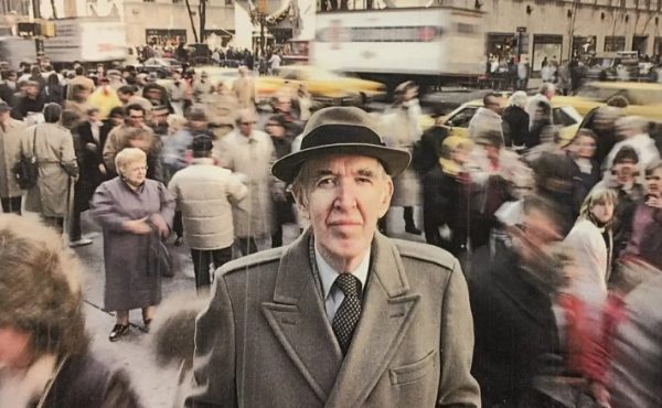
 In today’s New York Times there is an article on a walk English author Will Self took from JFK into Manhatten. It took him six hours. Self is a noted walker, and goes on epic hikes in London, and sometimes writes about them in his psychogeography column in The Independent newspaper. As for this walk, the Times writes:
By Mr. Self’s usual standards, the walk from Kennedy to Manhattan, about 20 miles, is a mere stroll. What recommended it was that it would take him through parts of the city that most people never notice while driving in a car: an experience that Mr. Self, a student of psycho-geography, believes has imposed a “windscreen-based virtuality†on travel, cutting us off from experiencing our own topography.
“People don’t know where they are anymore, “ he said, adding: “In the post-industrial age, this is the only form of real exploration left. Anyone can go and see the Ituri pygmy, but how many people have walked all the way from the airport to the city?â€
The article also mentions that walking on foot to the airport is a treacherous thing, as it involves walking on freeway on-and-off ramps. We have thought about walking to Pearson before, but not sure if it’s even possible without going onto freeway-like roads with no sidewalk. The closest I’ve come to doing this was riding my bike from downtown out to the airport a few years ago. I ended up on Dixie road, along the back of the airport (where the planes fly over extremely low) and circling around the top (where I saw Brampton Transit buses that caused me to fear that I had rode too far for my own good). Along Airport Road, there aren’t any noticeable entrances that look right for biking or walking. It’s strange to think of such a busy and populated place being somewhat hard or illegal to get to by foot.
The map and slide show for Will Self’s NYC walk (links on the Times site) show a side of that city that isn’t so sparklely pretty, one that had him looking forward to the “Brooklyn Bridge [where] we’ll hear the skirl of the Gershwin clarinets, and we’ll believe in the dream of possibility once again.†In fact, those pictures look a little like some of the unpretty, lowrise parts of Toronto’s inner suburbs, which are some of the best places to walk around in.
21 comments
I suspect the easiest (and relatively safest) route to bike to Pearson — but I’m not sure if the route has sidewalks or somewhere to walk off-road — is via Renforth going north from Eglinton. Renforth is a pretty calm street south of Eglinton (and Eglinton has a sidewalk/bike path until that spot).
Things (car speed) pick up north of Eglinton though. Off Renforth, there’s a back entrance into the airport on Silver Dart Drive.
(Not sure if you meant Dixie or Dixon — Dixie would make a pretty long route to the west of the aiport, and is one of the more intimidating main roads in the GTA — however Dixon (slightly quieter) runs into Airport Rd on the north.
Hmm Silver Dart Drive back entrance. Will have to look into that. Maybe we can do it sometime.
I did mean Dixie though. My route went along Eglinton, passed the airport & beneath the 401, then up superfat Dixie, over the 401, by the back of the airport, then east along the top to Airport Road.
I don’t mind bike riding on fat roads so much, as long as they don’t turn into freeways, which the entrances into Pearson seem to do.
We have thought about walking to Pearson before, but not sure if it’s even possible without going onto freeway-like roads with no sidewalk.
I have had to experiences with this. The first was arriving at Pearson with a bike and touring gear after three months riding in Europe. There is a way out on normal roads.
My second experience was getting on the wrong Lawrence bus to the airport and getting dropped off outside the airport. It was pretty rough figuring out how to get in, climbing over guard rails, down an embankment and then walking for about half a kilometre on sidewalk-less roads. I really wonder at the convoluted layers of flying roadways that they’ve added in the last few years to provide access to the new terminal. Are they really necessary? Or do transportation engineers have so little opportunity to build freeway structures any more that they have to grab any chance they can?
Biking to Pearson from Toronto probably isn’t so bad. I’ve been just outside the airport by bike. You can take Renforth and Silver Dart right into the airport (this is even suggested on Toronto’s bike map). The Eglinton “trail” even takes you right to Renforth if you want to avoid most of the roads around there.
The roads within the airport spiral around in amazing ways, but it shouldn’t be a big deal getting to whatever terminal you’re looking for if you follow the signs.
Not sure what the sidewalks are like though. 🙂
Maybe it’s cheating, but if you wanted to walk to Pearson the safest way to cover the last kilometre would be to walk into the new LINK train station at the reduced-rate parking lot (next to the 409 between Viscount Road and Airport Road), and take the train to either terminal.
It probably works for bikes as well (not sure if they’re technically allowed, but I’m pretty sure it’s physically possible).
A couple of responses:
Re: Dixie… it wasn’t just the “fat” that I thought intimidating. It seems to usually be filled with an amazing number of huge transports.
As for “the convoluted layers of flying roadways that they’ve added in the last few years”… I suspect that’s largely the result of building the new terminal, and the monorail, while providing temporary construction routes, and maintaining public roadways and terminals, etc. to serve the existing 3 terminals.
I always thought that must have taken some really complex planning — and making use of every bit of real estate (including aerial real estate) to keep it all working.
I would love to have been able to get a good view of the whole site at the time.
(But on the other hand, your theory about them keeping their expressway skills honed sounds pretty vaild too!)
Looking at Google satellite images it also seems that Jetliner Road can get you there from Airport Road. But not having tried it, I don’t know if their is a sidewalk.
I do remember reading “The Reichmanns” — biography of the famous billionaires — and one of them arrived on a delayed plane and chose to walk home from Pearson rather than ride in a car on the sabbath. I’m sure many people have walked to or from our airport, including many of the staff on days the TTC is on strike.
I’ve walked into the airport a couple times. This was before the Airport Rocket. I got off at the bus stop at Airport Rd and American Dr (extra fare required). Just follow the sidewalk to Terminal 3. It’s not far. From there you can take the Terminal bus to Terminals 1 or 2.
I once walked from the Winnipeg Airport to my apartment downtown. Took a couple hours.
That’s the part of Queens I lived in during much of 2004. Every seven minutes, a plane would take off, the dogs would start barking and people’s car alarms would go off. There would be some yelling, then calm for another few minutes before the next plane took off.
I would walk from 156th Ave. in Howard Beach to the bus stop, unless of course it was after 11 in which case I would have to walk all the way to the A train in Ozone Park, which runs local at that time of night, all the way into Manhattan.
God I hate that place! Looking at the route map is bringing back horrible memories!
For biking the Renforth/Silver Dart route probably works but you still wind up on the very dodgy windy roads inside the airport proper.
These days the best way to get there on foot or by bike is to go up Airport Road past the regular entrance to the airport and past the Airway’s Center complex of office towers and go into the reduced rate parking lot on the NE side of Airport Road (street address 6135 Airport road) from the parking lot you can use the free Airport LINK train to get into the airport proper.
There’s a stairway up to the internal road network from the corner of Airport and Bresler/Jetliner which connects to the internal bus network. There’s a helpful sign that says “Complementary Shuttle Bus to all terminals”. The TTC has a bus stop here as well, and there is a shelter to wait at.
I wonder once T2 closes if there will still be a public bus doing this route, though. Otherwise, walk to T3 from Airport and American Drive (ugh).
Remember that Silver Dart paralleling 427 has long been a fave spot for planespotters and submarine racers.
A decade ago, I took a conventional Metropass-friendly Dixon bus to under the 427 (any further and I would have had to pay extra), and walked the rest of the way, judiciously. It was daft but doable, provided you’re intrepid; of course, that was back when it was still old Terminal 1 and 2. Indeed, esp. w/old Terminal 1, it was a disarmingly placid crossing–mostly parking lots, lawns, or roadways w/more of a Silver Dart than freeway scale. (Because of that, I’d imagine I was far from alone; anyone from airport workers to Third World families might have done that stroll at one point or another.)
Now–I don’t know; I’d presume the risk may be less of getting injured or disoriented per se, than of being questioned/harassed by airport cops. But if anyone can report on the ped-feasibility (or lack thereof) of modern-day Terminal 1, it’d be welcome…
Also, thinking of my experience then: it may take a bit of pre-familiarity (through prior airport visits, etc–even by car) to make something like an airport visit less daunting. (And it’s interesting that, judging from the article, maps don’t seem to figure that prominently with Will Self; if it were I doing the walk, I’d pack a Hagstrom and reference it as surely as a Bruce Trail hiker uses his guide. It may violate psychogeographic “purity”; but hey, maps are sexy and tell their own kind of story.)
By and large, if I wanted to walk or bike downtown with a sense of procession, Renforth is too convolutedly back-doorish; the best way (and most evocative of the Will Self experience) remains something along the lines of Dixon/Scarlett/Dundas or Dixon/Lawrence/Weston. And the only thing that’d prevent me is obvious factors of time, energy, and perhaps weather conditions. But it’s definitely doable.
That’s quite an adventure, biking or walking around heavy transport infrastructure is a dangerous pastime, not one that I’d recommend.
Airports are designed to be the transport interaction between cars and planes, terminals are serviced with roads and carparks designed to efficiently get people (in cars) in and out of the airport. Pedestrian based journeys don’t come into the equation, and I would argue that many times they shouldn’t, instead the emphasis should be on well serviced public transport networks, rather than monopolized taxis or shuttle buses and large, expensive carparks.
I don’t think anybody’s being a thrill-seeker. Getting to the airport on foot is just…an interesting question. Can it be done reasonably safely? Seems like it can. I think everybody understands where the transportation focus should be.
But like, one sidewalk passing through that wonderful mess of curling roads, would be neat.
In case of any emergencies or unforeseen circumstances, why *mustn’t* ped-based journeys–even t/w such things as airport motel strips–come into the equation? Even if the ped traffic involved is quixotically negligible in practice. (Though if post-9/11 security concerns are part of it all, I sorta understand.)
“Airports are designed to be the transport interaction between cars and planes”
…which is a coldly transpo-technological way of looking at it. Why can’t it be framed as the interaction between *people* and planes?
Put it this way; when it comes to “accessibility”, I’d rather an airport function more open-endedly like a highway-exit gas station or fast-food outlet, than like the sealed environment of a highway-service-centre gas station or fast-food outlet. Not that the former is exactly “ped/bike-friendly” even on a default basis; it’s more the idea that one *can*. (If one wishes. And accepts all risks. And heck, if there’s a motel or something similar nearby, there may be more such impromptu ped traffic than you think–having stayed at such accomodation, I know.)
And beyond everything, that hypothetical “one sidewalk” Shawn speaks of; who knows, it could be actually be not only “functional”, but an incomparably dynamic cinematic-urban-futurist experience for those who’re willing–a draw, and (through being “designed” and “planned”) a reasonably safe draw, as well.
I guess it depends on how one defines “heavy transport infrastructure” and the degrees, or formidability, or exclusivity thereof, i.e. maybe it’s “inadvisably” daft to walk or bike along the hostile commercial/industrial desolation of Airport Rd or Dixon or Dixie; but at least you can do it. On the 401 or 427, you *can’t*, even by all but the stretchiest psychogeographic licence.
Perhaps to use the metaphor of a certain long-notorious airport-zone “underground” activity/economy, it’s like the difference between paying for sex, and paying for sex without a condom…
Back in 1996, it was possible to walk to Pearson; I did it. It was early on a Sunday morning, and I was seeing the woman who would become my wife back to the airport, after spending a week with her in Toronto. We were both short on cash, so we took the 58 Malton to the Toronto city limits. As we didn’t want to pay the extra fare (at the time, the TTC fare applied only to the 427; it hadn’t been expanded to encompass the airport), we got out and walked to Terminal 1, suitcases and all.
There was a network of sidewalks through the airport, some of which followed the road network, while others cut across it. We made it, though it wasn’t the most pedestrian friendly. But probably more pedestrian friendly than what this guy experienced.
That’s exactly my point; there was a vestigial “pedestrian friendliness” about, especially, the original Parkin ensemble–almost like a classic mid-century modern “neighbourhood unit” a la the Don Mills Centre transcribed into airport form.
However, in defense of urbanmike, I agree with the “emphasis should be on well serviced public transport networks” point, though from a more creative standpoint; not only is there nothing worse than being martyr to taxis and shuttles, but at its best public transit can actually serve as a nice mobile lazy-psychogeographer’s proxy, and is underrated as such. So if walking from JFK or LaGuardia seems a bit extreme or impractical, then get a transit pass and route maps from an airport outlet and judiciously string a route together t/w your destination, whatever it may be. And you get to be among the airport employees and just plain “real people”…
Can I revive this string? I am Will Self, and I’m coming to Toronto in October for the Harbourfront Series, and I’m fully intending to walk from Pearson into town. Any more absolutely rock-hard info on escaping from Terminal 1 greatly appreciated. For my walk to have the purity it requires it is essential that I not step in any form of wheeled transport once I leave the plane, so no shuttle buses, monorails on subways, even within the airport. A complete account – from my perspective, not that of the NY Times reporter – of my JFK-Manhattan walk (which followed a Central London – Heathrow walk at the English end), is in my forthcoming book ‘Psychogeography’.
In Anticipation
Will Self
We live in Wales in the UK. Our sponsored walk requires us to walk ( as Will Self said, no wheeled transport allowed) from JFK to Manhattan.We would appreciate all help regarding safe routes.
EUGhg2 cweipwuskyhb, [url=http://pekkyvbqcnyj.com/]pekkyvbqcnyj[/url], [link=http://ddypuwcecfwo.com/]ddypuwcecfwo[/link], http://ryyefwoiyntd.com/