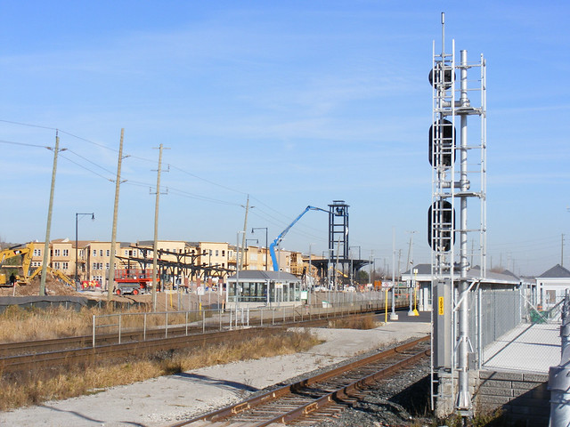
In northwest Brampton, at the junction of Bovaird Drive (formerly Highway 7), Creditview Road (3rd Line East), and the CN Halton Subdivision/GO Georgetown Line, is the small settlement of Mount Pleasant. Mount Pleasant (a bit of a misnomer, the immediate area is flat) was all but forgotten, but is now making an interesting comeback as an experiment in suburban greenfield transit-oriented development.
Mount Pleasant was never more than a collection of houses, two churches, a motel and a service station. The railway stopped serving the town by mid-century (being close in-between the busy railway junctions at Brampton and Georgetown), and Highway 7 bypassed the hamlet on a new railway overpass in the 1960s, also severing Creditview Road.
Suburban sprawl arrived around the turn of the century, and might have acted to eliminate the few traces of this small settlement. In fact, I recall when the first houses were built in the fields surrounding Mount Pleasant; on a rainy day, the clay being dug up for basements and streets appeared to be bleeding red from the top of the Highway 7 bridge. It appeared that Mount Pleasant was to finally endure the same fate as many other lost villages.
Old Presbyterian church and new construction behind.
But the railway regained a sense of local importance, as GO Transit chose Mount Pleasant as the name for its new station, opened in 2006. Highway 7, now known as Bovaird Drive, was widened about the same time to handle increasing traffic levels, but its 1960s realignment ensured that none of the remaining local buildings had to be demolished.
Most of the new building stock to the south and east of Mount Pleasant is typical suburban single-family houses, with a few townhouse blocks and shopping plazas, even though the adjacent GO station (also the terminus of five full-service Brampton Transit routes) would make the area ideal for higher-density development.
Perhaps recognizing this, the City of Brampton is attempting to develop a new-urbanist neighbourhood directly north of, and connected to, the GO station, with low and midrise mixed use dwellings surrounded by row houses and compact detached houses, much like Cornell in Markham.  Building the new Mount Pleasant village behind the GO station
The centrepiece will be a community centre and library branch that will incorporate the dismantled Brampton Canadian Pacific Station, originally located at Queen and Park Streets in Downtown Brampton. The station was moved in 1980 to a site not too far away, on Creditview Road, when threatened by demolition by the CPR, but it was later left to rot before heritage conservationists carefully dismantled the structure.
Unlike Cornell, which is isolated in a pocket of Markham’s sprawl, the new Mount Pleasant Village will have transit at its doorstep from the get-go, and will hopefully be more successful as a sustainable community. It is too bad, though, that the rest of the surrounding subdivisions are so predictable.
Below are some more pictures of suburban development in the surrounding area.
 Abandoned farmhouse on Mississauga Road on “SmartCentres” site.
 Creditview Road transforming from rural country line to residential street.


One comment
I just want to say I think this whole series is fantastic. Concise, interesting, informative stories about an important facet of our local history. I don’t see anything else like this in the newspapers, magazines, or blogs that I regularly read and am always happy to see a new post from this series. I learn something new from every article.
Looking forward to the next instalment!