


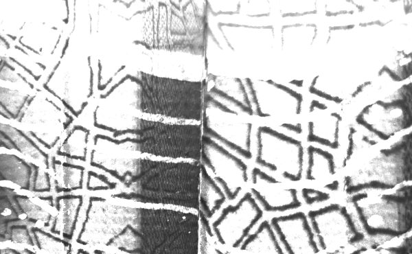
There were many great election-related maps being released this past week, and on the strength of many that I have created in the past, I decided to reinterpret some of the base data release by the City of Vancouver three-dimensionally as a means of clarifying the information.
The graphic here depicts Gregor Robertson voting percentage and its spatial distribution across the city. Percentage is straightforwardly shown in the vertical scale and is emphasized using a colour saturation/value scale – from the deepest blue representing the highest voting percentage to a very light blue, referring to the lowest.
This means of representation highlights several interesting patterns, a few of which are worth pointing out. On election day, Spacing Vancouver discussed the transition from an East/West ideological divide to a North/South alignment, and that trend is clearly visible again. Although the NPA made some strides in Coal Harbour and Hastings-Sunrise while ceding some of north Kerrisdale to Vision, most trades continued the trend. West Point Grey, NPA since COPE’s 2002 breakthrough, went solidly Vision, while the NPA won back swaths of Renfrew-Collingwood.
Much was made of Neighbourhoods for a Sustainable Vancouver and Randy Helten’s emergence as a mayoral candidate for disaffected COPE voters, not to mention the West End – but even there he only ranged between 5 and 10%, with Robertson’s dipping no lower than 55%. While this was Helten’s base as suspected, it was a rather small base and results elsewhere in the city were even lower. Only one poll (just across Burrard Street) and an advance poll were higher than the lowest West End poll.
Suzanne Anton was the opposition choice here, but of only between 23 and 37% of voters, including some of her lowest polls. As the map shows, West End discontent with Vision is widely exaggerated, or at least there were no viable alternatives this election.
***
Erick Villagomez is an educator, independent researcher and designer with personal and professional interests in urban landscapes. He is also the principal of Metis Design-Build, a practice that works on diverse projects ranging from small-scale architecture to urban design consulting, as well as information design/visualization. Furthermore, Erick is one of the founders and editors of Spacing Vancouver.
2 comments
Nice map Erik.
But since voting is at large (vs ward based), would be good to see absolute #s for Robertson vs. Anton by, since we know that certain polls reported much higher turnout than others.
Hi Dan,
Thanks for the comment…I agree with you 100%. Hopefully, I’ll have the time to visualize more of the data in the near future.
E