
For a larger image, click here.
![]()
A few months back, I felt like experimenting with different representation methods. Inspired by one of my favorite cartography books – Infinite Perspectives: Two Thousand Years of Three-Dimensional Mapmaking – I decided to go about learning how to create 3D anaglyphs. That is, stereoscopic 3D images created by encoding different images through each eye using filters of different colors, typically red and cyan.
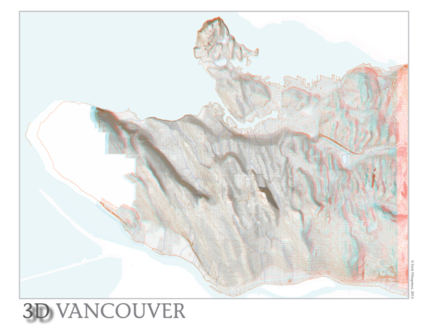
After some tinkering, I got a feel for the process and decided to turn my new skills to some of the maps that I created in the past. Naturally, something involving topography was a perfect fit and you are seeing the result by Ray Carlson & Associates – what I believe is the first 3d anaglyph map of Vancouver depicting the topography, city blocks, and historical stream system.
If you have access to some 3D glasses (ones with a red and cyan lens), looking at the image will really give you a good sense of Vancouver’s terrain and how it interacts with its city blocks, streets and streams. Queen Elizabeth Park (the dominant hill in the centre of the city), is particularly powerful visually. As is the ridge and valley that slices across the West Side and the few flat areas of Vancouver – including the False Creek Flats to the south-east of the downtown peninsula. The terrain that carved by the stream system is also a very readable in 3-dimensions.
I maximized the image size and kept things simple visually to not detract from the effect. Give it a try….it’s pretty fun and interesting to see the city spring to life from the page or screen!
Although I haven’t had much time to mess around move since creating this a while back, I hope to keep messing around whenever I get some free time. Stay tuned…..
***
Erick Villagomez is the Editor-in-chief at Spacing Vancouver. He is also an educator, independent researcher and designer with personal and professional interests in the urban landscapes. His private practice – Metis Design|Build – is an innovative practice dedicated to a collaborative and ecologically responsible approach to the design and construction of places.
3 comments
This is very cool!
Is there a good, high-res non-3D relief/torographic map of Vancouver you can recommend? Particularly one with vertical dimension emphasized? When I was biking Vancouver I longed for an accurate map of where the hills are. Google Maps’ terrain view is the closest obvious source, but I found it didn’t quite have the useful resolution (understandable as it needs to accommodate mountains rather than just 200 m hills as in Vancover).
Hi Jarek,
Thanks for the kind words…..and I’m happy to help in any way I can. What specifically are you looking for? Do you want the actual elevations labelled on the map? Or do you simply want a relief map? Here is a link to the original 2D relief map I published a while back. It is the base for the 3D anaglyph I created here. Since I created it, I have the high res versions and am happy to share. Just fire me an email.
Hope that helps,
E