After a scenic ride through El Poblenou and along the Barcelona waterfront, we approached the Sant Antoni market from the south, via Carrer del Comte Borrell, stopping at the Superilla Peatonal Sant Antoni intersection. This spot mirrored Poblenou’s with its low-cost public interventions and small-scale changes.
However, Sant Antoni Market played a more pivotal role, serving as both a conceptual and physical gateway. It marked where the Superilla experiment transitioned from its “tactical” phase to the more “structural” stage of its evolution. North of the beautiful building, the interventions along Carrer del Comte Borrell showed a greater degree of investment.
Carrer de Tamarit, north of the Market was redesigned as a “car light” through with new paving and a pedestrian plaza at its intersection with Carrer del Comte Borrell. Street furniture and planting were carefully integrated as a part of the new design.
As these changes unfolded, discussions arose about scaling the Superilla model to magnify its positive impacts. The nine-block cluster approach worked well as a pilot, but wasn’t practical on a city-wide scale—it would be impossible to transform streets in 3×3 clusters everywhere.
In 2019, the visionary Eixample Green Axes map was introduced, shifting the focus from an “oasis” strategy to a city-wide network. This plan committed Barcelona to spread the benefits of the Superilla concept to all citizens by connecting the cities’ neighbourhoods with these new green axes.
The “green axes” are streets redesigned to reduce or eliminate car traffic, replacing vehicle-heavy roads with green spaces, wider pedestrian paths, and bike lanes. These streets reconnect neighbourhoods by creating a network of pedestrian-friendly streets that encourage walking, cycling, and outdoor activities.
Complementing the green axes are public squares at major intersections, providing residents with open spaces for leisure and socializing. Filled with trees, benches, playgrounds, and shaded areas, these squares are crucial for increasing green spaces and improving air quality.
Given the people-first mentality, the social function of these intersections cannot be understated, transforming former car-dominated zones into vibrant community hubs.
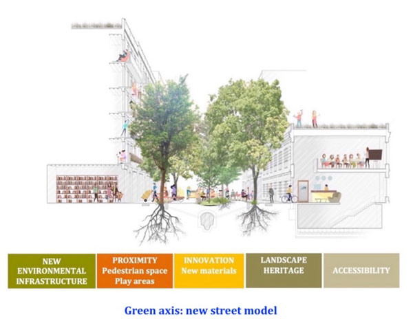
Together, the evolved Superilla expansion plans to create 21 green axes and 21 squares in the Eixample, greening over 33% of its streets and turning them into pedestrian corridors and green spaces. This new environmental infrastructure aims to ensure that every resident in the Eixample is within 200 meters of a green axis.
Last year marked a key moment for the Superilla initiative, with the City defining new design criteria for the green axes and outlining five principles in their new guidelines, as shown within the cross-section in the headline image. This ambitious project is ongoing, with several sections already completed, the most notable being Carrer Consell de Cent. Spanning over three and a half kilometers, this street transformation covers nearly the full width of the Eixample.
For context, the transformed section of Carrer Consell de Cent is about one-third longer than Vancouver’s downtown peninsula. It would be the local equivalent of converting a major thoroughfare like 12th Avenue from Main Street to Burrard Street. Since Barcelona’s Eixample has the same 66 ft. street widths as Vancouver, their template can easily be replicated locally.
The Carrer del Comte Borrell—the street that Honey-Roses, Martos, and Matilla guided us—holds special significance. Not only is it a green axis, but the stretch between Sant Antoni Market and Carrer Consell de Cent allowed us to experience the evolution of their urban transformation, step by step.
As we walked, Matilla shared lessons learned from each iteration, block by block. For instance, the City experimented with various paving patterns to encourage people to walk in the middle of the street. Not all designs were successful—changing paving alone wasn’t enough. Subtle visual and texture cues were needed to subconsciously invite pedestrians to walk in the center of the street. Carrer del Comte Borrell demonstrated this clearly, allowing us to see behavioral shifts from one side of the street to the other.
These detailed efforts were part of a broader evidence-based approach, where data was gathered and analyzed from both design-oriented observations and larger-scale metrics. For example, the City tracked the impact of street closures on city-wide traffic patterns. Initially, traffic on other streets increased, but after a year and a half, it declined, supporting the idea that pedestrian-focused interventions can change auto-based behaviours.
Our journey through Barcelona’s street transformations culminated at Carrer Consell de Cent, where we walked its length, exploring several unique squares designed to foster community. Walking down the middle of the street, Matilla explained the decision-making process in detail. This included policies that might seem surprising, such as limiting the number of restaurants allowed on this pedestrian axis to preserve essential community services. People first.
A Masterclass, indeed.
The session concluded with a warm aperitif with our gracious hosts, where our local planners eagerly asked more questions.
Looking ahead, Barcelona plans to complete the remaining green axes and squares, serving as a global model for cities aiming to prioritize people, community, and the environment over cars and congestion.
At the core of this transformation is a simple yet powerful motive—one shared with affordability policies discussed earlier in the series and rooted in centuries of evolution: enhancing the quality of life for all residents.
Throughout this process, citizens remain the focus, forming the foundation of every decision, from the abstract to the physical, from the small scale to the large.
We have covered a lot of ground. Let’s see what we can learn from Barcelona’s approach to the built environment…
***
Other pieces in the Barcelona Chronicles:
- Part 1 – Introduction
- Part 2 – Cerdà and Colau: Two Key Figures
- Part 3 – The Barcelona Housing Policy 2015-2023 Overview
- Part 4 – Defining Affordable & Social Housing
- Part 5 – Supplying Affordable Housing
- Part 6 – The 30% Measure and Others
- Part 7 – Vancouver v. Barcelona – Foundations
- Part 8 – Barcelona v. Vancouver – Strategies
- Part 9 – The Eixample and the Superilla
- Part 10 – The Superilla Pilot
- Part 12 – Vancouver v. Barcelona – Urban Design
- Part 13 – Reflections on Two Cities
**
Erick Villagomez is the Editor-in-Chief at Spacing Vancouver and teaches at UBC’s School of Community and Regional Planning. He is also the author of The Laws of Settlements: 54 Laws Underlying Settlements Across Scale and Culture.


