
Growth is largely considered to be a good thing; undoubtedly it’s better than shrinking. Detroit was once a city of 1.8 million; today it’s a bankrupt city of 700,000. If you have the choice, shrinking is not the way to go. However, growth is not a plan in itself.
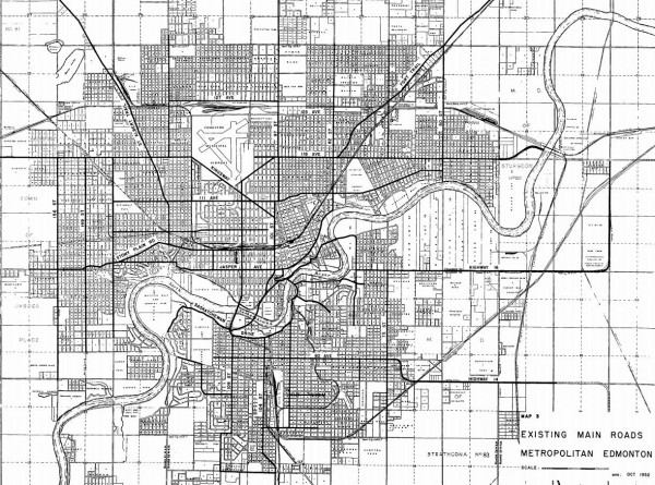
According to the City of Edmonton website, in 2012 Edmonton had a population of 817,498 and a land area of 699.8 square km. This means that currently the population density of Edmonton is about 1168 people per square km. This is a very low level of density. Compare this to Vancouver with 603,000 people in 115 square kilometres for a density of 5,243 people per square kilometre. Even Winnipeg with 663,000 people in 464 square kilometres has a density of 1428 people per square kilometre.
Edmonton is a very spread out city, making it a very expensive city to maintain. All of this space means Edmonton has more kilometres of roads, sewers, water mains, etc, than other cities with comparable populations. In spite of this very low density, Edmonton continues to grow outward, and recent bids for annexation will likely provide a steady supply of land for single family homes and their accompanying commercial power centres. So far we’ve been managing to continue on this path, but where will this growth eventually bring us?
Let’s do a little thought experiment and see what might happen, assuming we carry on doing exactly what we’re doing now with a modest growth rate of 2% per year. By the year 2043 the population of Edmonton would be 1.5 million and, assuming we continue with similar density levels, the area of Edmonton will have stretched to 1,293 square kilometres. Now is this possible? Yes, of course it is. At this point Edmonton will have swallowed St. Albert, Sherwood Park and Leduc.
There will be some problems, though. Then as now, there will be no cost effective way to move so many people around so large an area via public transit. More people will travel on the LRT, but the vast majority of people will still drive as it will continue to be more convenient for most trips. But traffic is going to be a big issue. Beyond the completion of the Anthony Henday, there are no plans for any new expressways. This means there will be nearly twice as many people, driving further, being funnelled onto longer versions expressways we have now. This is going to be unpleasant.
Now let’s go a little further into the future. Where are we in 100 years? It sounds like a long time from now. You’ll probably be dead, but your grandkids might not be. Where does this place us in the year 2113? At 2% growth a year the population of Edmonton will be 6 million people. At the current level of density Edmonton would be 5,172 square kilometres in size. This is four times the area of present day Los Angeles! The province of Prince Edward Island is only 5,660 square kilometres! How will people afford to drive around a city like that? What’s gas going to cost in 2113?
Edmonton is going to keep on growing but it can’t keep growing the way it has, at least not long term. If Edmonton wants to accommodate more people it’s going to have to have to start packing more into less space.
4 comments
Wondering if in this calculation you accounted for the fact that a large swath of Edmonton’s land area is rural and undeveloped, particularly in the northeast. The plans currently being discussed for the northeast do not encompass anything near all of the space up there. As a result, the density calculation you use and then extrapolate with is artificially low – which means that all your thought experimentation is potentially an order of magnitude out of whack, since it would be unlikely that much of that space would continue to be undeveloped or that we would continue to annex undeveloped space at the same rate.
Not to mention that using 1168 creates an artificial anchor point for what people think of as “current” density for Edmonton. If you told me the plan was to increase density in residential areas from 1168 to, say, 4500, I would think that’s a huge change and would be antagonistic to density-inreasing projects. But density in residential areas is already seems closer to 3500/sqkm (this number based on a half-dozen rough calculations using 2011 census population and neighbourhood area).
I’ve always been critical of overall density numbers to either gauge a city or to compare it to others. So many things affect the denominator that it seems practically useless for anything but a calculation of how much empty space there is to fill (as a related example, telling me that Canada is one of the least dense countries in the world does not relate to my experience living in a Canadian city, even a low-density one).
‘What’s gas going to cost in 2113?’…Not sure there’ll even be any by then.
Thanks for your comment. In answer to your question, no I have not factored out Edmonton’s swaths of vacant land. I have simply taken the official incorporated area of Edmonton and divided it by the official population. I’m sure if I excluded them, the density of Edmonton would be quite a bit higher. You don’t have to go to the northeast to find undeveloped land. There is a city block right downtown bordered by 103 AVE, 104 AVE, 102 St and 103 St that is a parking lot. It has a density of zero people and I’m sure is also putting my numbers out of whack. However, If my numbers are artificially low for Edmonton they are similarity low for the Vancouver and Winnipeg examples I used in my article as I also used their official areas and did not exclude their vacant lands. I tried to use Canadian cities with similar populations to be relevant. Comparing Edmonton to Prince George or Shanghai didn’t seem fair.
Perhaps I simply caught Edmonton at a period of disproportionately low density due to some recent annexation of vacant land. Let’s check that out.
1953 Edmonton had a population of 183,411 and an area of 105.6 Km ^2 for a density of 1736 pp/km^2
1973 Edmonton had a population of 442,365 and an area of 314.4 Km^2 for a density of 1407 pp/km^2
2003 Edmonton had a population of 688,940 and an area of 699.8 Km^2 for a density of 984.4 pp/km^2
Edmonton has annexed a lot of land. It is also proposing to annex more land to the south that will bring the land area up to 856 Km^2. This may also misrepresent Edmonton’s true density.
Matt: the last comments were not mine. 😉
Still, Vancouver is not a fair comparison since it does not take into consideration for the region which includes contiguous sprawl and represents >60% of the region itself. Uni-cities like Winnipeg and Calgary are fairer comparisons but density calculations are hardly a reliable measure considering Edmonton’s farmland makes up approximately 40% of the land. We could make Edmonton’s density calculations denser if we decided to eliminate the annexed lands we had in the past and still have suburban development happen outside the pre-existing city limits. However, that would not change the land use patterns despite the change in density numbers.
I still believe that dot density maps are more effective at look at the true density of cities. http://env-blogs.uwaterloo.ca/atlas/ has a good dataset from 2006 for all Canadian regions. The numbers are interesting: for instance, within a 5 km radius of the city core, Edmonton’s 5km core is denser than Calgary’s and slightly less than Winnipeg’s… again, these density numbers shouldn’t be the only measure we use to evaluate urban form, efficiency, and sustainability.