
Inside the Rockfield combined sewer overflow conduit
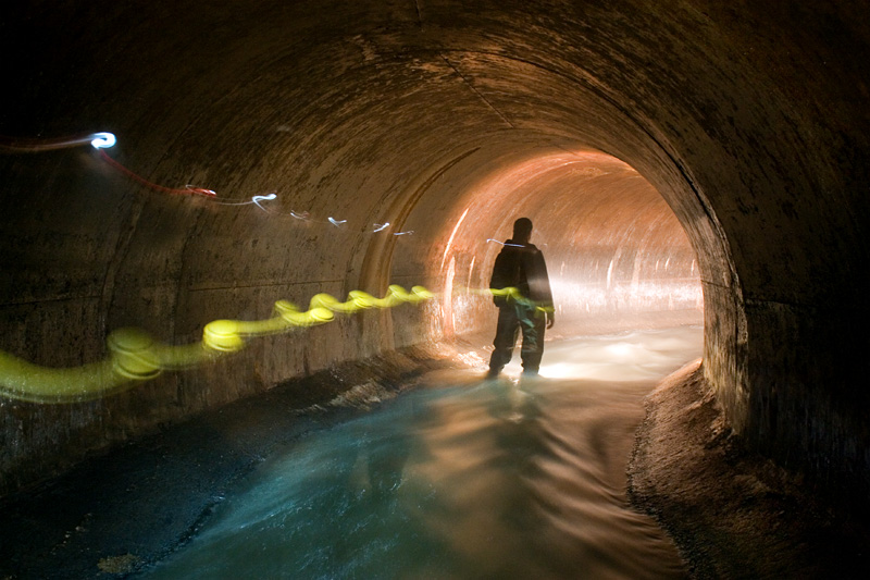
Picking up from where we last left off, this stretch takes us through the inside of the Cote-St-Luc collector sewer at the northern edge of Lachine. From here it snakes its way southwards towards the Lachine canal, never straying too far from the original course of Riviere St. Pierre. Approximate round-travel distance: 4 kilometers.
I never look forward to having to cover larger distances inside sewers here in Montreal. The depth will vary, but 2-3 feet tends to be the norm. That might not seem like a lot, but when you factor in the speed at which it’s flowing and the amount of gear these types of trips can entail, it doesn’t take long before it starts to feel like a solid cardiovascular workout. This is especially true when you’re walking against the flow.
Here’s a general overview showing the CSL collector (the darker red line), the estimated path of Riviere St. Pierre and a few of the features described below.
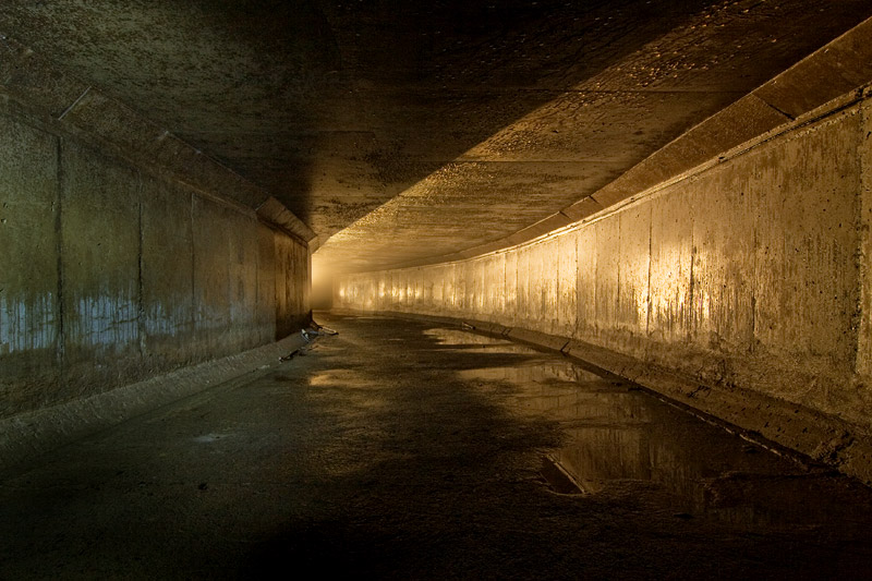
For the first kilometer and a half, this portion of CSL collector is pretty straightforward: 8×10 feet in diameter with a shape that’s typical of concrete sewers built in Montreal between the 1920s and 1970s. A smooth horseshoe arch covers a course aggregate floor that that slopes towards the edges. During dry weather, the edges of these types of sewers are usually dry. City plans define this section the “sidewalk”, but the term’s a bit misleading. Due to the angle, it’s actually terrible to have to walk on.
Typical Montreal-style sewer with “sidewalk”
Because of the broader arc of the sewer and for some of the features described below, I decided to name this length of the CSL Collector “Ovalflow.”
It’s unclear when the sewer replaced this portion of Riviere St. Pierre. While bits and pieces seem to have been covered as early as the 1930s, I suspect everything was eventually reconstructed during the mid-1960s when the entire area’s sewers were integrated into a much broader system.
By the time the sewer reaches the area of Lachine known as Rockfield, things start to get a bit more interesting.
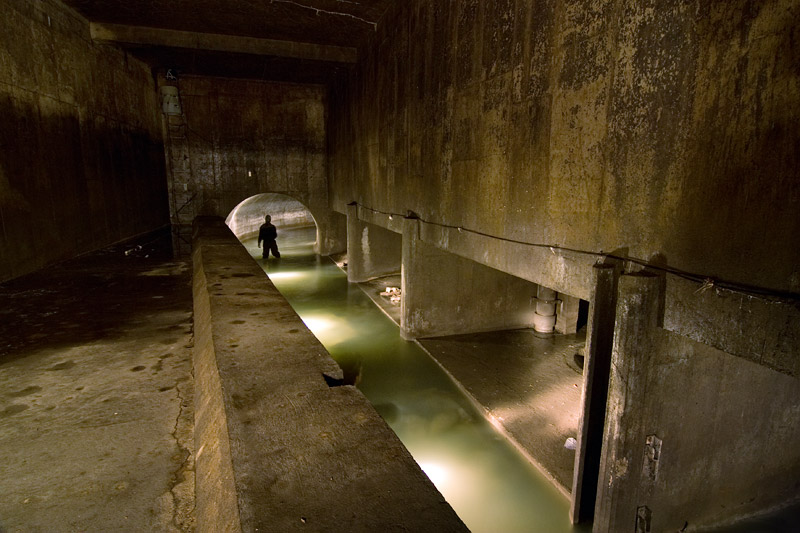
Rockfield flow regulator chamber
At this point the CSL collector officially comes to an end inside a rather unusual chamber containing a number of interesting features. As seen in the photo above, on one side of the channel are four cells. All the water flows into the cell closest to the camera at which point it falls down a sinkhole into an even larger sewer- the appropriately named St. Pierre Collector, which we’ll get to in future entries.
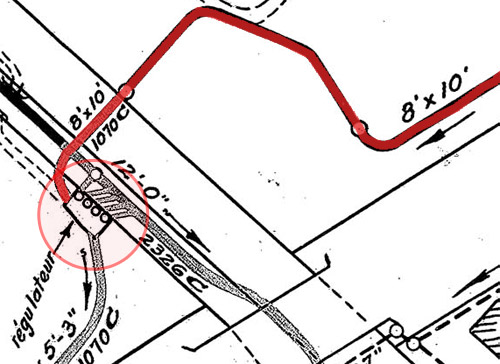
Detail of city planning map showing chamber and connecting sewers.
The other three cells contain a metal cylindrical object suspended directly above a three-foot wide hole, one of which is entirely blocked up with sludge. Above these are a number of counterweights and a mechanism (shown here) likely designed to lower each cylinder so that it covers the hole. Since each hole seems to lead to the same sewer further below, I’m not sure what purpose these things actually serve. A water monitoring device (or flowmeter) sits high in one corner of the chamber, but it’s unknown if it has any connection to the large plugs or if it simply sends an alert whenever water levels start to rise.
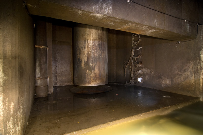
One of the chamber’s three cylindrical ‘plug’s situated above a sinkhole.
Also found in this chamber is the beginning of a rectangular shaped conduit situated roughly eight feet above the main channel of the sewer. The principle here is simple: when the water inside the sewer reaches a certain height, the surplus flow is diverted through this tunnel and out into the open water- in this case, the Lachine Canal.

Entrance point of the Rockfield overflow.
This is one of the drawbacks of a combined sewer system. Most of the time everything gets sent off to the treatment plant as intended, but during heavy rainstorms, the system can become overburdened to the point where sewage spills out into the open water. Fortunately, these events only seem to happen a few times a year, but they’re still a source of significant water contamination. If you’ve been warned not to swim in the Lachine Canal (or elsewhere on the island), combined sewer overflow events are likely the reason why.
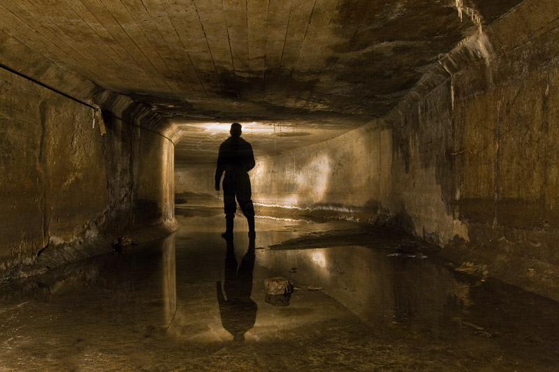
Midway point inside the overflow conduit approaching the Lachine Canal.
This eleven by five foot high conduit (known as the Rockfield Overflow) runs for a quarter of a kilometer, but because the outfall at the canal is submerged, one can only travel about two thirds that distance. Any further and you’re soon up to your chest in canal water.
At this point your only choice is to turn around.
Next up: Eastbound Traffic.
Crossposted from www.undermontreal.com
13 comments
Amazing pictures and such a good story!
You guys are doing hands-down the best urban exploration in town. Great pictures and — especially — story. Any books plans in the works? I’d buy it! :)
Heck, make a documentary film!
Absolutely amazing! Yes, Film footage would be wonderful to see.
Somewhat like constructing a subway system without trains, and far more necessary to the well being of a City.
Very interesting, and not without risk.
Thank You!
Thanks. I have been entertaining the idea of picking up a little video camera to supplement the stuff I’ve been posting, but for now photographs will have to do.
As for putting together a book, well.. I haven’t thought that far ahead yet. :)
The last remnants of what was known as Riviere St Pierre from Northern Electric Cable Plant opposite Dominion Engineering on 2-17 East thru St Pierre at the Bascule Bridge and into Canadian Car and Foundry works was a glutinous oil-sheened verdant mess.
It wound it’s way thru the old CNR Turcot Yard when the Roundhouse was still there, and was more swamp-like against the bank below Cavendish/Rose Bowl.
Lots of cat tails and frogs, etc.
They used to tip garbage off from St Jacques and there were lots of rats below the edge that could be seen whilst watching engines ‘coal’ at the coal tower.
Along the bank at yard-level were fenced gardens below St Jacques just to the West of Girouard.
Around 1951 a steam locomotive exploded at Turcot due to low water, and, supposedly, parts were blown up to St Jacques at Decarie.
We used to hang around Turcot in 1961 to watch them cut up steam engines, there being over 100 thee at the beginning.
People would throw matresses down, and then set them on fire, and the smoldering stink would pervade the ‘low-lands’ of the once-lake thru to St Remi.
As I recall, the Turcot Roundhouse was arsoned, then demolished in 1962.
Pullman now passes thru that way where the gardens were.
Memories.
Here is another historic photograph from the STM Collection.
http://www.stm.info/en-bref/tramways/description/S611123_20.htm
It shows an Eastbound Tramways snow plow just leaving the St Pierre station at Rue St Pierre bound for downtown.
The Bascule Bridge is out of frame to the left, and the Canadian Car and Foundry Works are directly left.
This was a busy station, as some of the CC&F workers clocked in and out here and there was a small store at the station where you could buy chips, soft drinks, etc.
CC&F was a huge plant and there was another Tramways stop east of here to serve the plant. Passenger and freight cars were built here, but, street cars were built at the CC&F Turcot East plant South of present Notre Dame West of Monk.
In the plow photoan oil truck climbing up onto the CNR double track at the right of the photo, cross the tracks and then the truck will either turn West to Dorval or East on 2-17 up to St Jacques thru to Cavendish and Decarie.
It may well go straight into Ville St Pierre, too.
The date on the photo is wrong, as the Lachine Line was abandoned in 1958.
The rails were removed, but, the trolley wire, which was copper, was left up, and drooped between the supports for quite some time thereafter, being stolen bit by bit.
Around 1960 or ’61, they installed a large concrete pipe along the Tramways right of way right about where the plow is sitting, between CC&F and the CNR right of way.
By then the CNR had completed their present line from Turcot West at the bottom of Brock thru Ville St Pierre and past the old Consumers Glass plant at Des Erables, parallel to now 2-20 to Dorval.
The old CNR line was routed thru Lachine, passing behind Dominion Engineering and North of Dominion Bridge, joining the present location just East of Dorval Station.
CPR was in the way, so CNR had to pay to have the CPR tracks moved slightly North, and the CNR mostly took over the old CPR alignment between CPR Ballantyne thru Grovehill and present Lachine to Dorval.
The Tramways was just South of the old CNR until the Tramways tracks turned South at 6th in Lachine.
Notre Dame now runs along the old Tramways right of way from St Henri to Ville St Pierre, with the pipe beneath.
When still active as a canal, the Lachine Canal was drained every spring and cleaned of junk thrown in over the past year that might be a hazard to propellors on ships, and also so they could inspect the canal walls and make repairs to locks and their gates.
A trickle of water was admitted at the Lachine Locks and Stelco?? on St Patrick street used to install pumps between the CPR Canal Bank Route and the Canal and pump water up in pipes during the draining period.
At the Cote St Paul Locks there was once a two-turbine hydro plant to the South of the Locks, where St Patrick now runs, to power local industry. These turbines were in a Gothic brick type structure of the late 1800s early 1900s.
At the CSP locks was also a feeder canal which ran South then East which, I assumed, MAY have water-powered the industry there with a low-head turbine or mill wheel device.
This was visible briefly in the Sixties when they were doing demolition work.
All so long ago.
I believe the Canada Car & Foundry “south” you are talking about is the current Krueger paper recycling plant on Notre Dame. They just threw aluminum siding over it. It’s still a pretty big plant but I suspect some parts of it may have been demolished – to make room for truck traffic?
Yeah, it used to belong to CC&F. The long narrow building closest to Notre Dame was owned by Dominion Glass. They later built a connection between that building and the one directly behind it, most likely when Krueger bought everything out in the early 60s. I have a map from 1957 that shows the same number of buildings that are there today so it doesn’t appear as though anything was demolished.
Thank You! The last time I was down there in 2007 I was on foot and, having a Metro Pass, Metroed to Place St Henri and walked West on Notre Dame following the once-route of the Lachine 91 Tramways route.
I explored around the area at St Remi, where the Lachine Car used to Wye after route cut back West from Terminus Craig and walked past where Notre Dame ended when streetcars were still in use to present-day Monk.
Back in 1961 we drove around the old CC&F works at Turcot East, and several buildings were being demolished then, but, they could well have NOT been CC&F structures in actual fact, but, some other firms on adjacent properties.
The buildings being demolished were of brick, and judging by the windows and other features, were quite old even in 1961.
There was once lots of industry between CNR Turcot at the Lachine Canal in that area.
I never did go back until 2007, and, at that time, did not walk South on Monk towards the Canal. I then walked to St Remi, past where Hiram L. Piper once made most of the coal oil railway lamps and flagging kits, under the CNR, over to where the Turcot Roundhouse once was and looked at the concrete mess above called Decarie, then got on an Autobus back at St Remi, returning to the present.
What a change. I preferred the Roundhouse era, hands down.
Here are two images from the Internet showing the Tramways Lachine Line, which parallelled the-then CNR Main Line to Dorval as far as 6th Ave in Lachine.
Westbound car approaches Dominion Bridge Spur and 6th Ave in Lachine. Dominion Bridge plant to right. In distance beyond CNR double-track is Dominion Engineering.
CPR bridge over CNR and Tramways on CPR line from South Jct to LaSalle in distance.
http://i17.photobucket.com/albums/b61/SDR_North/MTCDominionLachine.jpg
Following photo looking West from location of streetcar in above photo.
Dominion Bridge to left. CNR ‘Dominion’ station to right.
At some point the Tramways moved their line WEST FROM 5th to 6th, probably so Dominion Bridge could extend their plant.
Until recently, the Tramways tracks could be seen thru asphalt in street between CNR Spur and 6th.
http://i17.photobucket.com/albums/b61/SDR_North/DominionLachine050458.jpg
Back in the Fifties when streetcars were still in operation on the 91 Lachine route, the asphalt of Notre Dame West ended at the curve just beyond ave De Carrillon leaving the Tramways to travel West to Ville St Pierre and Lachine on their own private right of way.
In this view from the Internet a Westbound car, ( with the headlight ) has just left the West end of pavement on Notre Dame in 1951, as an Eastbound car heads East along Notre Dame for downtown and Terminus Craig.
http://i17.photobucket.com/albums/b61/SDR_North/MTCLachineRoute1951.jpg
Modern view of where pavement ended on Notre Dame into the Sixties.
http://maps.live.com/default.aspx?v=2&FORM=LMLTCC&cp=rkb5ys8w06sf&style=b&lvl=2&tilt=-90&dir=0&alt=-1000&scene=28380207&phx=0&phy=0&phscl=1&encType=1
In the early Sixties a large sewer pipe was installed beneath a portion the abandoned right of way.
Autobusses then operated on their own private road on the North bank of the Lachine Canal, a gate house being located approximately midway to turn back unauthorized traffic.
The large red brick and concrete building in the distance to the left is still extant at rue St Remi and Cazelais just below St Jacques.
The heavy cables on the poles to the left are trolley wire feeders from Tramways substations which are tapped into by the trolley wires at regular intervals to permit the trolley wire to be a lighter gauge/weight/cost than otherwise would be necessary to carry the current.
The trolley wires were divided into isolated sections with an insulating Section Breaker at each end of each section.
There was a ‘Section Breaker’ enamel sign hung from a crosswire indicating the ‘break’ to Motormen who were supposed to reduce the controller setting when the trolley pulley on the car passed thru the Section Breaker.
This was to reduce the ‘Arc’ that would result otherwise.
On busy city streets if he forgot, or was just lazy, a big arc flash and a ‘Bang’ would occur, scaring pedestrians and HORSES, especially at night, let alone damaging the wire-ends and causing surging in the traction motors on the car.
When a car passed beneath a Section Breaker, the lights would blink, the compressor would pause, if running, and the motors beneath would interrupt their drone.
The noise of the trolley pulley running along the wire was ‘telegraphed’ down the pole and was quite audible within the car itself.
The trolley sound rising and falling as the car passed beneath the support wires or through wire ‘switches’ where tracks joined, crossed or diverged.
When a car was stopped in a siding on single track, the opposing streetcar’s arrival could be heard in the wire as it approached.
Trolleybusses, when in Montreal, and present streetcars in Toronto use a carbon shoe in lieu of a pulley to pick up current from the wire which run quieter than a pulley.
Good video of a trolley ‘Arcing’ because of ice.
http://www.youtube.com/watch?v=nawukWL3POY
Trolleybusses have TWO trolley poles, and can arc, too.
http://www.youtube.com/watch?v=dKhMwrGUMcI
( Just imagine what a horse would think of this. )
With streetcars the electric current returns to the powerhouse/substation via the rails, which are mechanically bonded to cut their resistance, otherwise the current will ‘migrate to water mains, gas mains, sheaths of electric and telephone cables etc, causing these to corrode.
Subways, where they operate outdoors, can have icing problems on the current-carrying 3rd rail.
http://www.youtube.com/watch?v=dU-Ikg_o39A
Thoughts to ponder if streetcars or trolley busses are considered for Montreal.
In the good old days Montreal operated plows all night, and, if conditions were bad, operated streetcars on routes not having night service and on main routes just to keep the track clear and the ice off the wire.
Sleet Cutters would be applied at the barns in front of the pulley when required.
Another story that has gotten way too long. Sadly, most of it is now history, in the Montreal context.
The CN tracks that went west to Dorval, did they follow Victoria in Lachine? There are still tracks along Victoria from 1st ave to about 6th ave. I remember there being tracks to at least 25th ave or even 32nd. Did the trains then follow Victoria NW, then Bouchard in Dorval? That would join up nicely with the Dorval train station.
The CNR tracks in Lachine were located just south of Victoria Street. One station existed in the western part of Lachine. The station was located at 44th Avenue. Another station named Dixie was located just west of 56th Avenue on the Lachine – Dorval border, From that point the tracks ran straight down today’s Bouchard Boulevard.