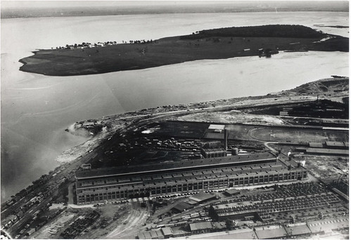
So it turns out that a good deal of Pointe-St-Charles is a dump. Literally.
Historically, the edge of the Pointe was a wetland, home to thousands of geese (could this be where the adjacent neighbourhoood of “Goose Village” got it’s name?). But between 1866 and 1966, household and industrial waste began to be dumped into the swamp. Between the 1930s and ’50s, dikes were built and the dump expanded right into the river, filling in part of the passage between Pointe-Saint-Charles and Nun’s Island.
The Société d’histoire de Pointe-Saint-Charles created this map which shows the evolution of the shore-line from 1801 to 1968.

I added the two stars above as reference points: the yellow star is the Maison Saint-Gabriel and the red star is the entrance to the CN shop, built in 1929. When they were built, both landmarks were on the water’s edge. Today, they are more than 500 metres from the riverbank.
In the image below, the yellow arrow below points to the CN shop in 2005.

In the 1960s, a highway was built along the waterfront, joining Decarie with the Champlain bridge in order to provide easy access for visitors to expo 67 and the dump was paved over to be used as the parking lot. It is estimated that 56 hectares (6 million square feet) of land – if a pile of pavement-topped trash can be called “land” – were gained by this means. This area has been developed as the Technoparc de Montréal.
The list and volume of contaminants found in this site is scary to behold: among other things, we’re talking about 3 Olympic pools worth of petroleum hydrocarbons contaminated with PCBs. Today, there are a series of pumps that work day and night to try and keep this buried garbage dump from further contaminating the river by diverting contaminated groundwater into the sewer system (whether our sewage treatment plant is equipped to deal with such a panoply of contaminants i s another story). The Commission for Environmental Cooperation of North America is pursuing the issue under the Fisheries act.
How disconcerting to learn that a piece of this island is not solid ground, but a century-old environmental disaster whose burden will be borne by generations to come. Even if the redevelopment of the CN yards does manage to create a bit of public waterfront access, there probably won’t be any beach-bumming along this coast for a long, long…dare I say ever?
—-
These photos and much of the information in this post were provided by Mark Poddubiuk, professor of urban design at UQAM. For more info about the site contamination: Commission for Environmental Cooperation of North America (2008). Factual Record: Montreal Technoparc (PDF).

7 comments
One of those classic out of site out of mind situations that may come back to haunt us. We need to take a good look at things like this that were built back when ideas about waste management were based on simply moving it somewhere else. The Verdun waterfront is all landfill too and you can still walk along the old “boardwalk” which was at the top of a cliff before the water. Nun’s Island was also expanded by garbage and Metro dirt. It’s probably at least 4 times the original size today.
Toxic goo from the Technoparc area has been leaking into the river for years now. You can see (and smell) the stuff if you go down to the shore just upstream from the Victoria Bridge. The booms and absorbent pads installed there are nothing but a PR band-aid.
the technoparc has a bio-remediation project going on, you might want to include this fact somewhere in your article.
Also one thing about landfills creating land nobody wants, at least they make good cruising areas. Can you spot the one that is in the photo?
So did Drapeau do us all a favour back in the 60s and 70s by destroying Goose Village and re-zoning Griffintown?
If they were cognizant that the ground was already contaminated, perhaps it was a wise decision to develop transportation and industrial development in this sector – if it was residential, doubtless the people living there would be in considerably poorer health. I can’t fathom why they figured it was a good idea to continue extending the shoreline with garbage, though its not that bizarre when you consider the park islands were enlarged by the same means. By concentrating major contributors to local pollution on already polluted land, at the very least they focused the problem, making it slightly easier to control.
Mind you, this is all conjecture. It would be interesting to find out whether the real-estate developers, CLC, the Cité-du-Havre or the city have considered whether this highly polluted area is ideal for new residential development.
Is there any evidence to suggest letting nature reclaim polluted land helps speed-up the recovery process, or are those pollutants here to stay?
Scary stuff, great article!
Quelque part dans Bonheur d’occasion, Gabrielle Roy fait allusion au “bidonville de Pointe-Saint-Charles” et je me suis toujours demandé si c’était justement sur les remblais de déchets que celui-ci se trouvait.
Also good to point out that the extension of the shore-line from 1963 to 1968 was mainly the works of the city land filling from the construction of the metro.
This is really no surprise. The bottom of Pointe Sainte Charles has long been an industrial wasteland. But it’s slowly evolving. The end of Bourgeois Street, which leads into the train yard pictured above, once had a Union Carbide filling station on its last block (I know, because I lived on that block for quite a while). Now that is gone to give way to condos. And I have heard talk that the old engine shop may also be put to the same use. As the use of this part of the city transforms, the ecological concerns grow. Lots of post-industrial Montreal faces the same dilemma…