
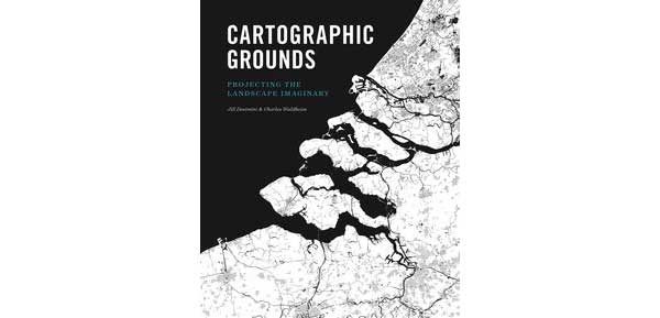

Authors: Jill Desimini and Charles Waldheim (Princeton Architectural Press, 2016)
Reflecting on the history of humankind, one is hard-pressed to find a form of graphic representation more influential than the map. From the Babylonian World Maps to John Snow’s 1854 cholera map of London to the now common Google Maps, their societal significance throughout the ages is undeniable.
Although there is much debate about the first ‘map’, the practice goes back millennia and, since its inception, people have continually attempted to push cartographic boundaries, in terms of what maps can depict, and how. This has particularly been the case within the architecture and landscape disciplines, where drawings are used as, both, a form of speculation and a means of physically describing a place or proposal. It is with the latter in mind that Jill Desimini and Charles Waldheim have graciously given us Cartographic Grounds: Projecting the Landscape Imaginary—a wonderful compendium of maps that explore the potential of cartographic practices and tools across a variety of disciplines.
The book is broken up into ten chapters, each highlighting a single cartographic technique—Sounding/Spot Elevation, Isobath/Contour, Hachure/Hatch, Shaded Relief, Land Classification, Figure-Ground, Stratigraphic Column, Cross Section, Line Symbol, and Conventional Sign. Mohsen Mostafavi, dean of the Harvard Graduate School of Design, opens the book with a short Foreword, while Antoine Picon, Director of Research also at the Harvard Graduate School of Design, nicely closes the book with a succinct Afterword.
Words are used sparingly, however, and large bodies of text are few and far between in order to make room for the incredible array of visual material. Although the beginning of each chapter takes a small handful of pages to describe its designated technique and its potential, the vast majority of the book is given over to the beautiful maps by various designers and cartographers, created across centuries.
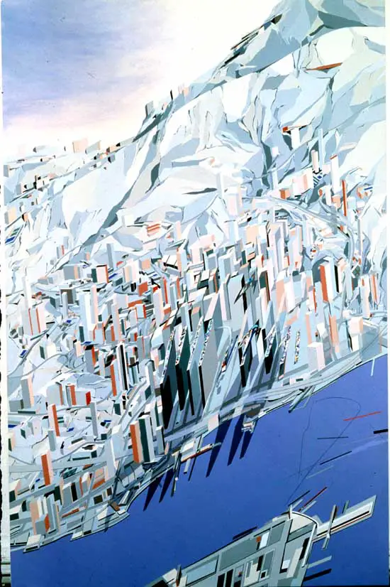
Beyond the visuals themselves, the most provocative aspect of the book is the conscious choice to avoid organizing the images chronologically. Instead, the authors decided to use juxtaposition as a method of explicitly demonstrating the potential of the each technique and allowing the reader to draw meaningful connections between examples. Comparing Eduard Imhof’s incredible 1938 Karte der Gegend um den Walensee beside Zaha Hadid’s The Peak, for example, one immediate appreciates the similarities and differences in their use of shaded relief and, simultaneously, how their technical mastery was used towards telling their unique narratives.
Simply powerful.
Other great comparisons abound, cutting across an wide range of renowned and lesser-known designers and map-makers. From Giambattista Nolli’s seminal map of Rome—that you can now explore in full online!—to Anuradha Mathur and Dilip da Cunha’s Pettah 2 Plot from their influential book Deccan Traverses, and Humboldt’s Distribution of Plants in Equinoctial America: According to Elevation above the Level of the Sea of 1854 to Colin Rowe and Fred Kotter’s Drawing of Wiesbaden Street Plan that served as the cover of their important book Collage City, readers will be inspired at the turn of every page.
Given the above, I do not hesitate to say that Cartographic Grounds: Projecting the Landscape Imaginary is a must-have for all designers, architects, and cartographers interested in mapping as both a speculative tool and descriptive form of representation.
Author Robert Harbison once said that “maps are the most condensed humanized spaces of all…They make the landscape fit indoors, make us masters of sights we can’t see and spaces we can’t cover.” Through their great work, Desimini and Waldheim have done their part to open our eyes a little bit wider.
***
For more information on Cartographic Grounds, visit the Princeton Architectural Press website . You can also see more images in Jill Desimini’s article for Places Journal.
**
Erick Villagomez is one of the founding editors at Spacing Vancouver. He is also an educator, independent researcher and designer with personal and professional interests in the urban landscapes. His private practice – Metis Design|Build – is an innovative practice dedicated to a collaborative and ecologically responsible approach to the design and construction of places. You can see more of his artwork on his Visual Thoughts Tumblr and follow him on his instagram account: @e_vill1.
