
While Toronto is often called the “city of neighbourhoods,” there is very little visual material that celebrate these areas (outside of customized street signs and pole banners). Enter Brendan Hennessey, a local urbanist who took it upon himself to research the origin of neighbourhoods, local street names, and the current elements (social, cultural, political) that give each area its character.
You can see this feature in our Winter 2012-13 which is still on some newsstands across the country for a few more days.
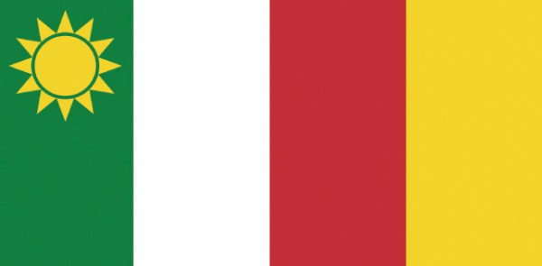
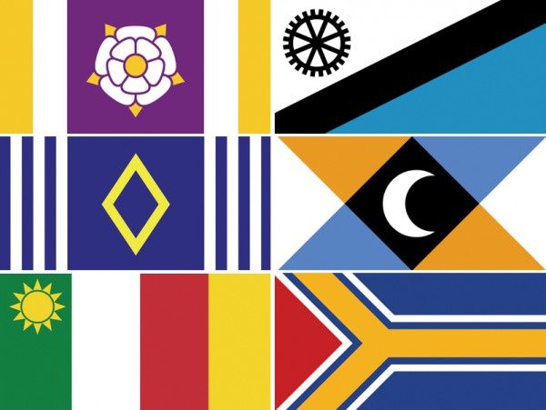
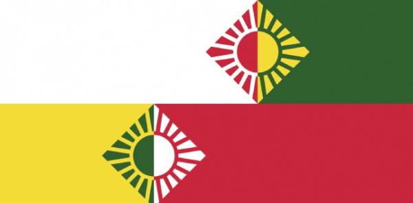
College Street
The flag colours are based on the flag of Italy, with the golden sun taken from the Little Italy street signs.
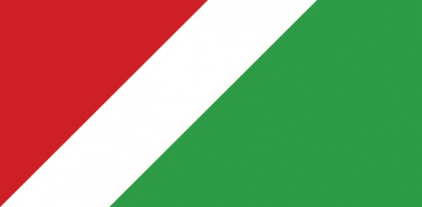
Christie Street
The red triangle in the top right is derived from the Mr. Christie Cookies logo (which the street is named after). The sloping green represents the hills of Christie Pits.
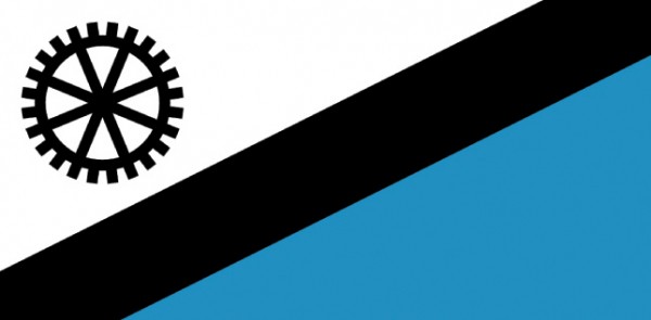
Old Mill Drive
The black diagonal stripe and white background are taken from design elements of the Old Mill’s Tudor architecture, while the blue area represents the mill’s source of power: the Humber River.
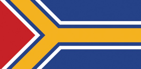
Yonge Street
The sideways Y symbolizes both the street’s name and the colour used on subway maps that denotes the Yonge line.
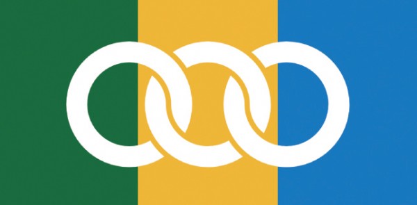
Eglinton Avenue
Green represents the numerous parks that Eglinton passes by; blue represents the rivers and creeks it passes over; and gold represents the Golden Mile, Scarborough’s famous car sales strip. The three rings are taken from Earl of Eglinton’s coat of arms and joined together to represent Eglinton’s status as the one major road that links all six of the former municipalities.
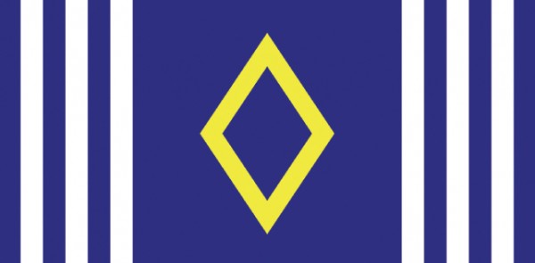
Dufferin Street
The diamond symbol is from Lord Dufferin’s coat of arms, while the stripes symbolize the length of the street which touches both the northern and southern boundaries of the city.

Dupont Street
A stylized bridge, which is a canting (basically a heraldic pun) of the road’s name. The blue and white colours represent the former edge of ancient Lake Iroquois, while orange is the main colour of the iconic Dupont subway station.
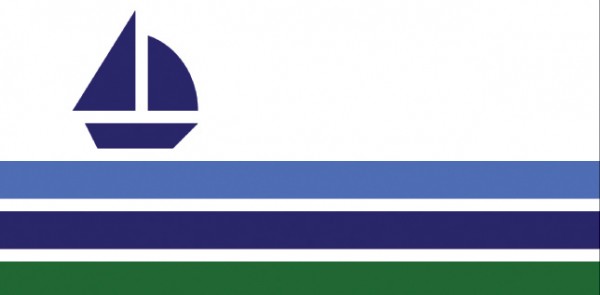
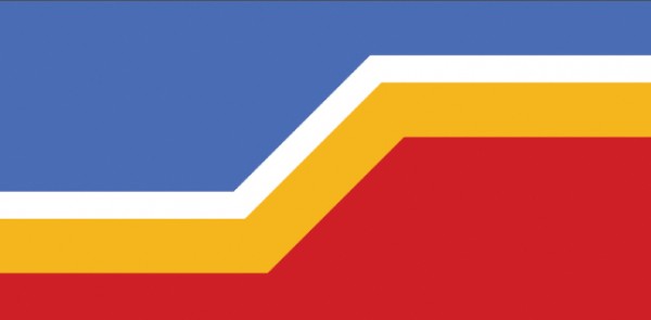
Lake Shore Boulevard
The three stripes represent the shore, the lake, and the sky. The sailboat is a common sight on the waterfront and is used as a symbol by some of the Lakeshore BIAs.

Davenport Road
The crescent, black and white colours, and diagonal lines are taken from the coat of arms of the English Davenport family. The diagonals also represent Davenport’s deviation from Toronto’s grid system.
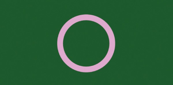
High Park Boulevard
The green symbolizes the park, the circle represents serenity of the park, and the pink denotes the park’s cherry blossoms.
Roncesvalles Avenue
The horizontal red and white are derived from the Polish flag — the long standing community on Roncesvalles — while yellow and green symbolize the small Spanish town the street is named after. The four colours are connected by a set of British Colonel pips, representing the regiment who won the 1813 Battle of Roncesvalles.
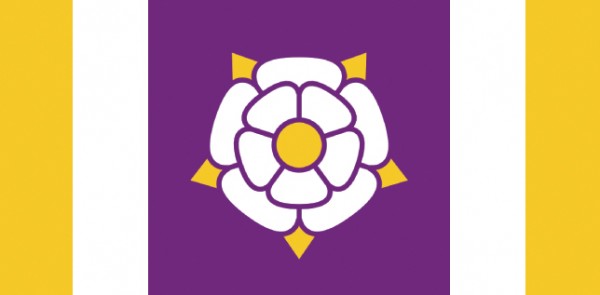
Royal York Road
A York rose on purple (a traditional royal colour) with gold bars that mimic the colours of Royal York’s subway station tiles.
Spadina Avenue
The word Spadina is derived from the Ojibwe word “Ishpadinaa” meaning high hill. The stripes mimic a hill and create a stylized “S.” Red and gold represent the Chinese community and the blue and white the vacated Jewish community.


17 comments
Where’s the one for Bloor?
No representation of toronto’s native heritage. Lots for its white settlers. Nice.
No Danforth? Once again, the cool kids think Toronto ends at the Don Valley.
Nothing from the East Side?
Laura:
Well yeah… I mean there’s the Don Valley and then like Oshawa, right?
Wow, my fellow east enders are crybabies. Relax, neighbours. Relax.
Brendan is working on a series and he started in the west side. Bloor, Queen, east side, etc will makes its way.
– Matthew Blackett
Spacing publisher
To above commenter Eli: I don’t know what you were reading but 2 flags have native meanings. And, in the intro, it says the flags are derived mostly from more contemporary conditions.
DesPite some of the negative comments above, I want to tell Artist that these are sweet-ass designs! Flag are hard because of their minimalism yet have to say so much. Brendan has done this very well and deserves lots of kudos for this.
These are terrific. Congrats to the artist-herald for a great job.
Well then, I’m looking forward to the rest of the series, for sure! 🙂
Thanks for the comments everyone!
Eli, you bring up a really good point. I definitely missed an opportunity to highlight Toronto’s native heritage. Your post inspired me to a make a flag for Vaughan Road: http://i.imgur.com/Z2smqFf.png
The diagonal stripes at the centre of the flag symbolize Vaughan Road’s diagonal path through the street grid, and suggest the left side of the letter “V”. The stripes are in the colours of a medicine wheel, representing the road’s history as a native trail. The green area on the right side of the flag represents the nearby Cedarvale Ravine.
This is a fascinating and creative representation of the city’s neighbourhoods. Bravo! As a Church & Wellesley gay village dweller, I can’t wait to see what the artistic comes up with. (I imagine the rainbow might appear in some form but I’m curious to see how!)
When will spacing will selling these (magnets? buttons?) in the spacing store?
I think a very underrated street is Coxwell Avenue… It feeds into the mouth of Ashbridges Bay and the beach. Do you have a flag for that?
Interesting, a feel-good idea, but there are issues here.
I think we’re confusing “streets” and neighbourhoods. Any one “street” in Toronto could anchor many different neighbourhoods (like Bloor/Yorkville, Bloor Annex, Bloor/Koreatown, Bloor West Village/High Park). How many flags are we going to have, and who’s to decide which flag is a fit representation of the neighbourhood?
And, I think “culture” should be avoided; at what point in history would one take a snapshot of Kensington Market’s “cultural profile”? Times past when Eastern European was dominant, or of late as Chinatown crosses west of Spadina? Cultural references are “contemporary” – but Roncesvalles is is mentioned as “long-standing Polish” which sounds more historic than contemporary.
There could/would/should also be clamour if some cultures are less celebrated (not honoured with inclusion in a flag’s motif) while others are celebrated/included – Eglinton is a long street, part of which is “Little Jamaica” (Eglinton West from Marlee to west of Dufferin), but it’s not an area that is widely celebrated as a Toronto feature community; compare with Greektown on “The Danforth”…
Great start to a great project. Congrats on the idea and the cool execution.