

Pedestrians are often accused of putting themselves in danger by crossing wide, fast streets at locations where there is no traffic signal. But in many parts of Toronto, traffic signals are 1 km or more away from each other. A pedestrian who wants to cross the street midway between them would have to detour a full kilometer, a walk of approximately 10-15 minutes, in order to use traffic lights. One could call this a “safe crossing desert.” Yet the city’s traffic signal decision process does not take such distance into account.
Yesterday, Toronto’s Public Works and Infrastructure Committee was deadlocked on just such an example — a proposal, submitted by a local councillor on behalf of local residents, to put a traffic signal at the intersection of Victoria Park Avenue and Conroy Avenue /Donora Drive. The nearest traffic signals are 535 metres to the south and 565 metres to the north. As Walk Toronto’s Michael Black pointed out in his submission to PWIC on this item (PDF), in downtown terms, that’s as if there were no signals across Yonge Street between Richmond and College (disclosure: I am a colleague of Michael Black’s at Walk Toronto).
Transportation Services staff opposed this proposal. When the City gets a request like this, staff will assess whether it meets a “warrant” — that is, specific conditions required to support it. For traffic signals for pedestrian safety, they require 200 pedestrian crossings during the busiest times of the day.
Traffic services only counted 105 crossings. They further noted that, although the posted speed is 50 km/hr, the actual average speed of traffic was 67 km/hr.
That leaves roughly 105 people daily who have to brave extremely fast traffic to cross the street, with no practical alternative within a reasonable distance. Transportation services noted that there haven’t been any pedestrians hit at that location in the past five years — but as Michael Black points out in his submission, we should not be required to sacrifice a pedestrian every time we want to improve pedestrian safety.
If no-one lives in an area, then it might be reasonable to leave such a long stretch of road without a safe crossing. However, this is in fact a residential area, with some foot traffic and transit stops that need to be accessed from both sides, including one right at Conroy on the east side of Victoria Park. At the moment, the transit stops on the other side of the street are spread out, so pedestrian crossings may not happen at the exact spot where the traffic signal is proposed. However, if there was a traffic signal in place, some additional people would likely divert to cross there. As well, the staff report notes there is the potential that those transit stops will be consolidated at this location in the future.
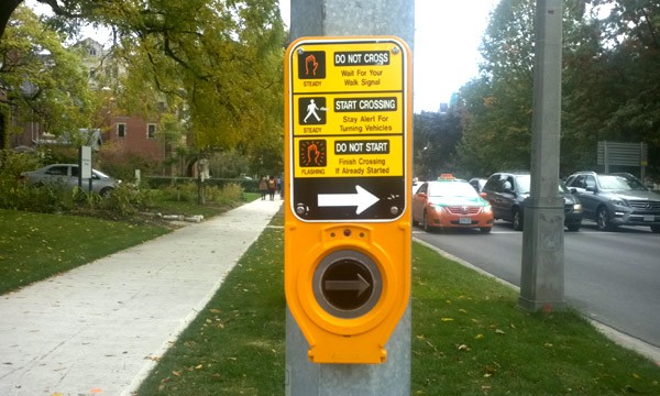
Finally, a point staff make in supporting a different traffic signal further north on Victoria Park, at the Gatineau Hydro Corridor (PDF) applies equally to the Conroy/Donora location, and to every other proposal to install a traffic signal for pedestrians safety: namely, these would be “actuated” signals that only change when a pedestrian or vehicle is waiting to cross. If no pedestrians or vehicles are waiting, the signal won’t change and traffic won’t be interrupted. As staff say, “The traffic control signals will only be activated in the east/west direction when a … user … is present. In this case, any additional delay from the new traffic control signal is expected to be limited.” The signal would only be used when it is actually needed, and if fewer pedestrians cross, the signal won’t change as often.
A good start to solving this problem would be straightforward — add a signal distance factor into the warrant for traffic signals. The warrant could state, for example, that if the nearest signals are half a kilometre or more distant, then a signal is warranted even if only 100 pedestrians are observed to cross in a day.
It could also reduce the requirements at locations where there is a transit stop without any nearby signalized crossing, since anyone using a transit stop will likely need to cross the street at either the beginning or end of their trip. If Toronto want to encourage transit use, it needs to make it safe to access transit stops.
All over the city, there are inhabited locations with nearby destinations where pedestrians would have to detour a kilometre or more to find a safe crossing point. With Toronto looking into a road safety strategy inspired by the Vision Zero concept of reducing traffic deaths and injuries, it’s time to create more safe crossing points in these “safe crossing deserts.”
4 comments
We live near that intersection and have seen the need for a pedestrian crossing. Victoria Park Avenue is only one lane each way at that point (whereas it expands to two lanes each way both to the south and to the north), so it’s not a huge distance to cross, but it’s certainly difficult to do so when traffic is busy.
Beyond speeding drivers of cars, pickup trucks, etc., the zone is very bus-heavy. This is both a blessing and a curse. Many local residents (of a mix of apartment buildings, townhomes and houses) take public transit, but going each way means–of course–getting on and off on opposite sides of the street, with no safe way to cross between the two. The irony is the very bus you take poses a safety hazard to you as a pedestrian. This problem has been compounded by the (otherwise positive) introduction of express buses, which do not stop anywhere along the stretch from Vic Park subway station to St. Clair.
The problem is further compounded by situations like last weekend, when the subway line was closed from Vic Park to Kennedy, with shuttle buses racing along this stretch (among others).
Don’t get me wrong, I know we’re very lucky with the public transit situation in this area. It’s just that it and the needs of drivers need to be balanced better with the needs of pedestrians, particularly the elderly.
When they check to see if a crossing is warranted at a given intersection are they counting the number of crossings only at that intersection? Because I would think they should be counting the number of crossings made between Dawes and the golf course (a huge stretch) not made at those two lights.
Basically, everybody who gets on the bus at the transit stops between those two lights presumably would need to cross the street on the return trip. So I wonder if 105 crossings is the real number.
Also, to add to the point about crossing a street given the cars’ speeds, crossing anywhere near the hill at Donside Dr. adds to the danger because the hill is steep enough that you can’t see approaching traffic close to the crest. When I used to cross Vic Park I made sure to cross far away from the top of the hill.
67 km/h!! There is no way the average speed at that specific location is 67 km/h (let alone something like the 85th percentile). Maybe they measured traffic speeds a little farther to the south, going down the hill toward Crescent Town, where drivers really pick up speed because (a) downhill (b) wide open — that I would believe.
Follow up note – the traffic signal at Victoria Park and Conroy was passed by City Council.
http://app.toronto.ca/tmmis/viewAgendaItemHistory.do?item=2016.PW12.15