
The designs for the Lower Don Lands from the 4 shortlisted teams in the “Innovative Design Competition for the Lower Don Lands” being run by the TWRC were released today in conjunction with an exhibition (including lovely models) at BCE Place. The Exhibition Launch and Public Forum is on Monday April 16 from 6-9 pm at the Allan Lambert Galleria in BCE Place (181 Bay Street). PDF’s of the full display panels are available from the TWRC website.
———————————————————-
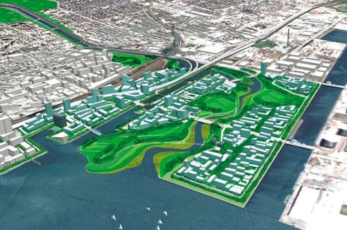
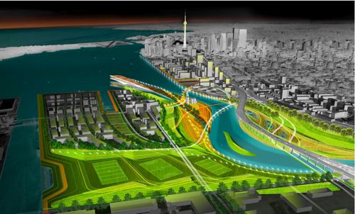
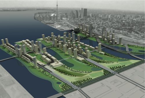
STOSS INC./Brown + Storey Architects/ZAS Architects
STOSS INC., Boston, MA
BROWN + STOREY ARCHITECTS, Toronto, ON
ZAS ARCHITECTS Inc., Toronto, ON
Brookner Studio
Nina-Marie Lister
Applied Ecological Systems
Pine + Swallow Associates
Nitsch Engineering, Inc.
Moffatt + Nichol
ARUP
Kidd Consulting
Consult Econ, Inc.
The Map Office
———————————————————-
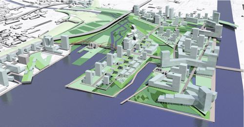
MVVA/Behnisch Architects/Greenberg Cnsltnts/Great Eastern Ecology
Michael Van Valkenburgh Associates, Inc. (MVVA), New York & Massachusetts, USA
Limno Tech Inc., Michigan, USA
Applied Ecological Services Inc., Wisconsin, USA
Great Eastern Ecology, New York, USA
Greenberg Consultants Inc., Ontario, CANADA
Behnisch Architects, Los Angeles, CA, USA & Stuttgart, DEU
Transsolar Energietechnik, New York, USA & Stuttgart, DEU
RFR Engineering, Paris, FR
Totten Sims Hubicki and Associates (TSH), Ontario, CANADA
ARUP, Ontario, CANADA
———————————————————-
Weiss/Manfredi & du Toit Allsopp Hillier
Weiss/Manfredi, New York, NY
du Toit Allsopp Hillier (DTAH), Toronto, CANADA
McCormick Rankin Corporation
Golder Associates Ltd.
Biohabitats, Inc.
———————————————————-
Atelier GIROT/Office of Landscape Morphology/ReK Productions
Atelier GIROT, Zurich, Switzerland
Office of Landscape Morphology, Paris, FRANCE
Jà¼rgen Mayer H., Berlin, GERMANY
ReK productions
Arup, California, USA
Philip Ursprung
Applied Ecological Services
———————————————————-
crossposted to bricoleurbanism.org

21 comments
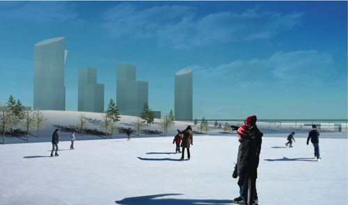
I wish water still froze in Toronto
These are some exciting designs. Now how long until TEDCO decides to build an ugly monstrosity on the site instead?
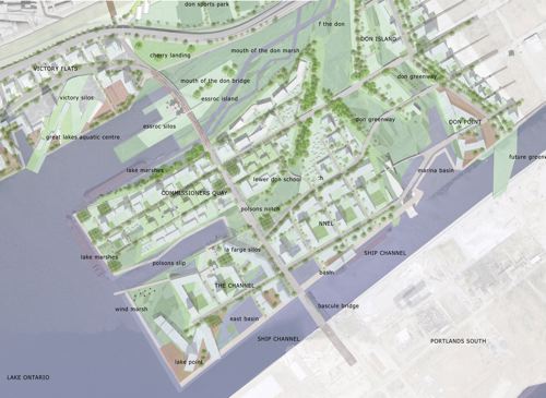
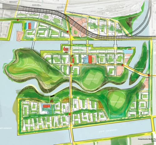
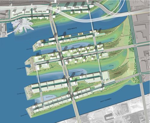
Some exciting designs, but what planet are they living on? Am I missing something? Where is Commissioner’s Park and the new Toronto Film Studios?
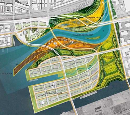
To green and gay: Yeah, I was surprised to see Commissioners Park wiped out too — I thought the main focus of this competition was north of the Keating Channel. But the various sports fields in each proposal seem to try to replace it. The TWRC may have gotten ahead of itself planning Commissioners Park in isolation. As for FilmPort, it’s immediately east of the Don Roadway, which is the hard right edge of each map.
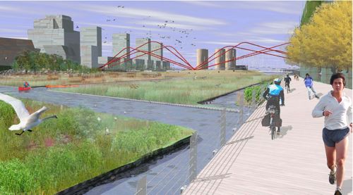
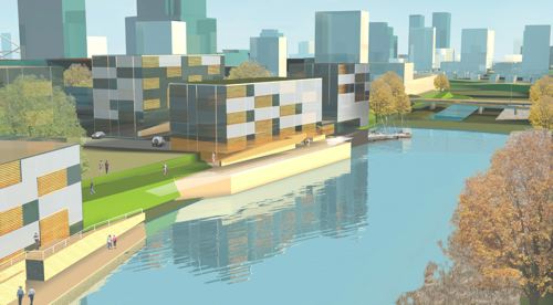
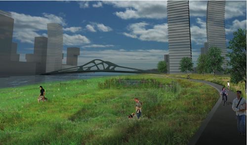
What is the giant red spidery thingy in the first group’s 3rd pic? Some kind of bridge?
I haven’t yet moved to Toronto — that will finally come in the summer — and don’t know this part of town well. Can anyone explain where the site is, well, sited, in terms of other landmarks and so on?
I Google Mapped it, and from what I can tell the Lower Don Lands seem to be immediately below the Distillery District. Is that about right — and, if so, is there (will there be) a pedestrian connection between them, or does the rail corridor make that pretty unrealistic?
Finally, what else is walking distance from the Lower Don Lands?
All of the designs look pretty city in the park. It’d be unfortunate to build a smaller St. Jamestown down there.
Why are we crowding the waterfront with more high rises? As it has already been said, this will just be another St.Jamestown – Social isolation by high rise.
What is needed is a move toward a real community. They have the recreational space covered, but add in a main street with essential shopping and ammenities within walking distance, and eliminate most, if not all, of the highrises and replace them with low rise buildings, townhomes and detached homes. This will lead to community involvement and the creation of a new community in the style of the Beach or Bloor West.
And does anyone think the proposed high rises are incredibly boring!
Why are high-rises “crowding the waterfront” but single family homes, detached homes and etc. aren’t? If anything, high rises give more people a chance to live in this area.
The year I lived on the 19th floor of a high rise was as (or as not) socially isolating as when I lived in a Seaton village Basement or the 2nd floor of an Annex house.
I’ve never understood the ideological high-rise hating reflex. Lots of people quite like this kind of living.
“And does anyone think the proposed high rises are incredibly boring! ”
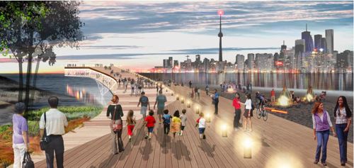
These are preliminary design proposals for the layout and landscaping of the neighbourhood, not the buildings.
Keep in mind that the competition program was not all about designing urban form. It was about the River and how it could be improved. Don’t make the mistake of getting hung up on how the buildings are articulated. I think that it was a deliberate move to show the open space in more detail than the architecture.
Disparishun: The TWRC and City have designated the waterfront lands as transit priority. Connectons will be great for people without cars. Granted, the buildout for the Portlands is far enough into the future that kinks will work themselves out in time. First to come will be the West Don lands and East Bayfront, two sections of the atefront that are much further along in planning and design. Check the TWRC website for more info on all the projects.
Thanks BARAY for pointing that out. I know that this is a long way off, but with the stuff the TWRC seems to have up thier sleeve (TEDCO), who knows what they are planning.
My statement that they are crowding the waterfront is meant from an aesthetic point of view, not a matter of density. Personally I think the buildings near the skydome are an eyesore and do not compliment, in design or location, the city’s waterfront, nor do they provide any kind of pleasing visuals when looking toward the lake. I just don’t want this to happen to an area that could be so much more. I am not downplaying the value of high rise buildings. I have lived in them myself, and they are needed, but I found them to be much more introverted than any townhouse, low rise or detached home I have ever lived in.
I was considering the proposals along the terms set out on the TWRC website, of the goals stated is:
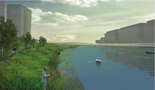
“to create a vibrant riverfront neighborhood in harmony with the naturalized mouth of the Don River. Appropriately-scaled development and recreation blocks […] that highlight the river and respect its ecology,”
The designs put forth show a beautifully landscaped area, canoeing, etc. surrounded by large buildings. In my opinion, and interpretation of the criteria, I don’t believe that is “appropriately scaled development.” Also, as I mentioned before they speak of a vibrant neighbourhoods, and I don’t see that occurring when high rise buildings are involved. I personally know of no “neighbourhoods” made up of such buildings that could be considered “vibrant”
Keep in mind these are only my opinions and I simply want to create discussion about this. It is great to have a site that allows such debate.
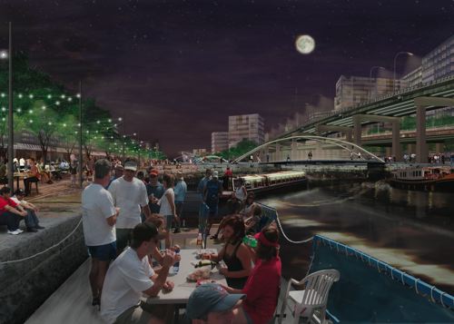
I had a similar feeling to JM and some of the others. These look rather like suburbs — clumps of buildings isolated from each other and the city. I’m not sure you’d really get all those people they depict in the public spaces.
Of course, I’m biased, since I wrote my own vision for the Port Lands in Spacing’s Past and Future issue.
Re. Commissioner’s Park — it’s a good thing they got rid of it, it was a bad idea that isolated the Port Lands from the rest of the city. Not all of these proposals are better, though.
As for the buildings themselves — fortunately, there is another option between high-rises and detatched homes — midrise buildings (say, 8 storeys), which provide density but don’t overwhelm or isolate. I definitely found the two proposals that focus on midrise rather than highrise buildings to be more appealing.
Dylan…Suburbs.. Perfect! I have been trying to think of the best concept to describe it and I can’t believe I didn’t connect the two. I agree with the mid rises, and I actually like the Stoss designs for that (contrary to my “boring” comment earlier), those mixed in with townhomes, and detached would definitely work. Also, I am not sure if this is a lack of detail issue, or I just haven’t zoomed in enough to the PDF’s but is there space designated for a commercial stretch, similar to Queen or College streets, or would that be finalized in later consultations?? Could we assume anywhere the Light Rail goes would be more commercialized? Anyone know? Am I just rambling now?
It could be served by LRT on the existing GO ROW (visible in several of the pics) which runs along the north side of the site and goes west to Union Station and northeast through Riverdale to Scarborough. Also, the Parliament streetcar could extend down through the site to the beach, perhaps along Cherry street, to give north-south service.
Pretty pictures overall. No false notes and no stirring crescendoes.
The only way this can work is to have high density, low rise, like in the Weiss/Manfredi plan. It’s been proven time and again that the ‘tower in the park’ does not work. The density of people has to be high enough to create a ‘happening’ place. Otherwise it’ll just be a desolate enclave of overpriced condos, a new kind of suburb as mentioned above. There will have to be lots of commercial and institutional space to make it work, and this has been called for in the design briefing.
Disparishun, here’s a map
for you with some of the areas around the site. It’s central in many ways, it’s an unprecedented opportunity. I just hope that the build-out will a)happen, and b)stay true to these designs.
sorry, this is the correct map link
I agree that some of these designs look very suburban and have a Flemingdon Park/Don Mills kind of feel to them — buildings plunked down that don’t relate to streets or to each other — especially that Stoss one.
Hard to tell from these images – hopefully the design they pick will create some interesting, busy “high streets” in which people will feel at home…. and not just focus on places for people to rollerblade.
Thanks, Citydan. I did Google Map it but, not being on the ground, I don’t really understand some of the lived geography of the area. Is it really just below the Distillery District? Can you walk from one to the other, so that they could eventually form a pretty contiguous part of town?
The drawings are all nice and fine, it is also ok do dream and to discuss what we would like to have there, but we are forgetting one little detail here: this is Toronto, nothing ever gets done, so don’t keep you hopes up. The waterfront will still be a desolate place when our great grandchildren are in their nineties…
The competition brief specifically asked that the built areas be mixed-use, which would make for a healthier neighbourhood. More than one presentation brought up St Lawrence as an example of a dense and livable neighbourhood built more or less from scratch.
St Lawrence, of course, had the advantage of being within walking distance of downtown. The Lower Don Lands will probably always feel a little isolated from the rest of town, but a mix of uses and incomes will help.
Disparishun – the north part of the site is a quick walk from the Distillery District, and at least one proposal included opening new underpasses under the railway tracks to add additional connections. However, in most of the proposals the “urban” part of the redeveloped site ends up separated from the rest of the city by the alignment of the newly renaturalized river mouth, so the walk / ride ends up that much longer.
(I’ve put some more commentary on my site, incidentally, based on my frantically scribbled notes from the presentataions.)