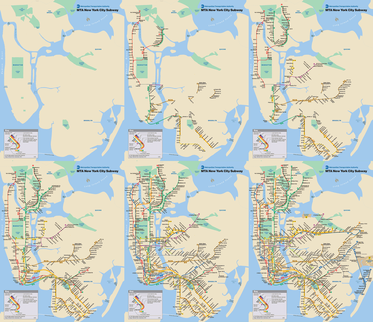
Check out this New York City subway map — it shows the growth of the subway system in order of the year each line was constructed. What’s kinda neat to see is that the subways first appeared in the Brooklyn area, not in the dense downtown area. And if you like subway maps, check out the many different NYC subway map manifestations dating back to the 19th century (or go to a local Subway sandwich shop and look at the walls).
This post is also an open challenge: the person who produces the best animated map like this for Toronto’s subway construction, and sends it to us, will receive a set of Spacing’s subway buttons (value $49). Let’s say the deadline is Friday at noon so we can post the winner by late afternoon. Click on the “continued reading” link below for the dates of Toronto’s subway expansion.
Let the animated GIF competition begin!
The stretch underneath Yonge Street between Union Station and Eglinton opened to the public on the afternoon of March 30, 1954. This was followed by the following extensions (note: official/VIP openings in brackets if different from public openings):
- • University (Union Station to St George) — February 28, 1963
- • Bloor-Danforth (Keele to Woodbine) — February 26, 1966 (Feb 25)
- • Bloor West (Keele to Islington) — May 11, 1968 (May 10)
- • Danforth East (Woodbine to Warden) — May 11, 1968 (May 10)
- • Yonge North (Eglinton to York Mills) — March 31, 1973 (Mar 30)
- • Yonge North (York Mills to Finch) — March 30, 1974 (Mar 29)
- • Spadina (St George to Wilson) — January 28, 1978 (Jan 27)
- • Bloor West (Islington to Kipling) — November 22, 1980 (Nov 21)
- • Danforth East (Warden to Kennedy) — November 22, 1980 (Nov 21)
- • Scarborough RT (Kennedy to McCowan) — March 24, 1985 (Mar 22)
- • North York Centre Station — June 18, 1987
- • Spadina (Wilson to Downsview) — March 31, 1996 (Mar 29)
- • Sheppard (Sheppard-Yonge to Don Mills) — November 24, 2002 (Nov 22)
thanks to Eli Singer for tip


9 comments
When I saw this map, I was all “I wish one existed for Toronto.” God bless you, Spacing.
What a wonderful idea!
Although it would be extremely cool, and maybe more appropriate to the form of Toronto’s network if the map also included the streetcar network and radials.
(Or continued on to show the Transit City/MoveOntario2020 plans!)
Cool, but also deceptive in that it doesn’t show the network of els that originally served Manhattan and were later removed… hence the perception that “the subways [i.e., rapid transit] first appeared in the Brooklyn-area, not in the dense downtown area”.
You probably could map all streetcars, radials, and bus routes based on the information at transit.toronto.on.ca — it’s a mind-bogglingly thorough site. You wouldn’t be able to throw it together by Friday, though.
For authenticity the “hole at Eglinton West” should appear and disappear 🙂
Mark  not to mention the Bay/St. George interlining!
I’m so determined to win. I love those buttons!
The Queensway right-of-way should be shown as well, following by the Harbourfront right-of-way, Spadina right-of-way, and the first portion of the St. Clair right-of-way.
Queensway (Queen)  Claude to Humber loop opened 1957/07/21.
Harbourfront  Union Station to Spadina & Queens Quay loop: 1989/06/22.
Spadina  Spadina Station to Union Station: 1997/09/27.
Harbourfront  to Bathurst: 2000/07/16
St. Clair  St. Clair Station to Vaughan: 2007/02/18.