
On a long, lonely drive, highway destination signs are a welcome friend. They assure us that as we press on, we are working towards a goal and that we will eventually find a place where something tangible awaits.
As with most urban infrastructure, there is a story in the details of how these signs are designed. For example, on Highway 401 west, a sign in Whitby states that you are still 51km away from Toronto. In less than half that distance however you will cross the Rouge River and be welcomed to ‘Ontario’s Capital’ raising the question of just what exactly that distance is measuring.
According to the MTO, the distance marked on the signs is determined by the route required to get to the seat of government of the identified municipality. In this case, the sign in Whitby is not telling you that you are 51km away from entering Toronto but that you will have to drive 51km to get to Nathan Phillips Square. In the case of municipalities that lack a formal City (or Town) Hall, the distance is measured to a point called the City Centre; determined by calculating the geographic centre of the built up region.
The MTO is also very systematic in the way it places the signs. Look, and you will notice that signs are always found either after an intersection with another provincial highway or when leaving a municipality that was mentioned on a previous sign. Another interesting detail is that signs in Ontario are focused usually on Ontario destinations. While most travellers to Fort Erie are probably passing through on the way to the border, signs mention the Ontario destination up until the approach to a cross-border city.
The details behind these signs are a testament to the thoughtful detail and careful design of Ontario’s unique highway signage system; defined by utility and by oddities such as the crown and shield theme. They also lead us to think about what we define as the centre of our cities. Just what exactly is the geographic point that formally marks a city? When have you truly arrived in the ‘heart’ of a city? Is the seat of government usually close to this point and is that still relevant to where most people are travelling? Next time you’re reassured by a distance sign on a long lonely drive, this is something to think about.
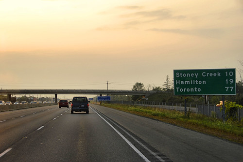
Photo of highway distance signs by Scott Stewart


24 comments
The photo you use brings up an interesting thought. “Stoney Creek” technically no longer exists, at least no more than “Scarborough” exists. Using MTO’s logic, it shouldn’t be used as a waypoint since it neither has a ‘seat of government’, nor a true City Centre.
Ahh the joys of amalgamation.
Algonquin Park has a city centre?
I do wish the signs would incorporate out-of-province destinations too. For example, it’s nice to see Toronto mentioned on Quebec’s road signs, yet Montreal is never mention on Ontario’s.
@ Blair, I think the MTO still has signs up for all the old cities that are now Hamilton doesn’t it? Is there still a sign letting you know you are in Ancaster, and directing you to Ancaster City Centre? In the case of amalgamations, it is probably still useful to keep the old signage for way finding. I think they should have kept the signage on the downloaded provincial highways as well.
Eastbound on Highway 403 a sign tells you that you have entered Hamilton, and then another sign a couple of kilometres down the road says “Hamilton Downtown 20 km”, since the western edge of the amalgamated City of Hamilton is a long way from the downtown of the old city of Hamilton. The sign appears at what used to be the western limits of Ancaster. There is also signage that indicates what exit/road will take you to the downtown for many cities and towns.
For anyone interested in the history of Ontario highway signs there is this site:
http://www.thekingshighway.ca
Jason beat me to the punch, I am always startled to see signs in Montreal for “Toronto”, but you don’t see signs in Ontario for Montreal until very close to the border with Quebec.
I know that New Brunswick refreshed its signs a long time ago in relation to complaints that many of the signs advertised destinations in other provinces, especially Nova Scotia and PEI, to the detriment of New Brunswick itself.
Interesting! I always assumed the signs were referring to the distance to the border/edge of the place.
As for your question about the centre of cities, I’d say the current system speaks volumes. The history of Western politics is obsessed with sovereignty, even though it is highly paradoxical. The current signage system also works to reinforce the notion that cities are these reasonable, rational things with a clear location of power, and that power flows through the centre. Obviously, this is not the case.
I remember as a child watching the little green and white signs marking each km as the family car sped down highway 400. I kept imagining there would be a final sign marking “0km” when we finally reached Toronto.
Is not the distance to the city centre a Roman tradition?
It always strikes me as odd coming east on the 401 from the airport that Algonquin Park is the first destination sign I see. Really? There’s nothing in between?
Then you get the weird signs – usually to rest stops – that are at unexpected multiples of distances, like 32km. Weird, until you realise that they’re still there from pre-metric days, when that would have been 20 miles.
Interesting post. I’m sometimes puzzled at the intervals between distance signs. On the 401 east of Toronto, you might not see one for more than an hour, and then you’ll see two in reasonably quick succession.
The province recently started putting distance markers on major roads to some important Ontario tourist destinations, hence the “Algonquin” signs. If memory servces, you’ll also see a distance sign to Niagara Falls either on the QEW in Mississauga or on the 427 leading away from the Airport. The are positioned to be seen by people leaving Pearson Airport, since that is the province’s most significant point of entry for visitors.
I think these could be used more widely, for more tourist destinations, and perhaps in more logical places. It’s hard to imagine many people touching down at Pearson and heading straight to Algonquin Park!
With respect to distances shown on signs, there are only a few cities in the province that are big enough that the difference between border and seat of government is truly significant on a long drive. Also, city boundaries change. Rural land gets annexed. Amalgamation aside, City Hall’s don’t move very often.
It does seem logical to put cities in other provinces and states on the boards. Let’s not be so provincial 😛 !
During the referendum ice storm years in Montreal, some of us anglos saw the constant reminder of Toronto on A20 down the road as a last resort refuge. Funny, we moved to Toronto, Ontario anyway….
While westbound from Montreal you do get “Toronto” as a direction, that’s probably because there’s pretty much zilch in the way of any Quebec destinations between Montreal and the border. I would guess that Quebecois have better things to do than to visit Cornwall.
Does Ottawa get a mention at the 40/540 junction? I suspect it does, but it’s been ages.
Most Ontario border crossings are over large bridges, except for the southern end of eastern Ontario, and Highway 17 into Manitoba.
Toronto is a good place to see old “The King’s Highway” signs, along the now-decommissioned Highways 2 and 11/11A.
No offense to the people of Cornwall, but I don’t think Cornwall is worthwhile as a “control city” (the municipalities given status as destinations on mileage/’kilometerage?’ signs and directional signs). Kingston has a decent population and is a legit destination. Cornwall, in my opinion, is not. Kingston makes sense, but after Kingston, Montreal should be the control city.
Some signs on A-20 on the West Island in Montreal though have Dorion as the control city, though Toronto is noted as the control city in the inner core and the junctions with other Autoroutes. Yes, A-40 does have Ottawa as the control city, at least once you hit A-540. A-15 south has New-York (the City or merely the state?), while A-35 has “Vermont”.
In the other direction, London is appropriate enough as a control city, as is Windsor, especially as the 401 ends well shy of the Detroit River. Sarnia for the 402, because what would otherwise fit? Flint?
But as soon as you hit Detroit, you notice that the Americans generally use control cities sparingly on the Interstates. I-94 has Chicago as the next control city (not say, Kalamazoo), and as once you hit Chicagoland, St. Louis (I-55; not Springfield), Milwaukee (I-94) or “Iowa” (I-90; Iowa City, perhaps?) become the control cities. Similarly in Buffalo: your control cities are Erie PA or Albany (where you get the choice of New York City, Montreal, or Boston).
In Arizona, the control cities for I-40 are either Los Angeles or Albuquerque – they don’t even bother with an in-state destination, ever, slighting Flagstaff.
It is 553 km from Toronto, Ontario to Toronto, Ohio, or 1,872 km to Toronto, Kansas. I keep mixing them up.
“Most Ontario border crossings are over large bridges, except for the southern end of eastern Ontario, and Highway 17 into Manitoba.”
There’s also Highway 61 from Thunder Bay (purposely numbered to correspond to US Highway 61 – yes, that Highway 61) towards Duluth, Highways 63, 65, 66 and 101 in northeast Ontario cross into Quebec by land. (I will concede that in the cases of 61 and 63, they cross over a rather short bridge).
I remember a few years back taking an Ontario Northland bus to Timmins. At the start of the 400 there is a sign that says 300 km to North Bay. After about 7 hours on the bus (makes stops in every two bit town along the way) we leave the North Bay city limits and you think you have made it through the worst – but most maps use different scales between northern and southern Ontario. The next sign says Timmins is 300 km away!
After another 4 hours on the bus you see the sign that you are entering the city limits, then the next sign says ‘Timmins City Center 50km’!!!
Let’s just say after that bus ride, I no longer fear hell.
I’ve returned to this interesting post and set of comments again, because I found myself reflecting on the fact that I find the highway signs sort of calming. There’s something about the font, that seems to only vary slightly between signs, and has remained more or less consistent over the years, that I find reassuring.
Bob: You’re thinking of the famous FHWA series of fonts that were developed specifically for highway signage in the US. There are free downloads of this series of fonts (they range in variation in terms of spacing and character width) – they’re called RoadGeek or something of that sort.
New road signs in some US States (as well as the City of Toronto’s expressway and street guide signs) use the newer Clearview font series. The MTO hasn’t yet embraced Clearview over FHWA, though there are a few perhaps experimental installations – Toronto-bound QEW at the Red Hill Creek Expressway and there’s one destination sign on the westbound 401 that merely says “Toronto 95” near Cobourg. The newest signage (for example the 410 extension into Caledon) still uses FHWA.
I’m curious what makes Ontario’s highway signage system so unique? Nothing here seems much different than the similar signs I’ve seen in BC and Alberta.
I think Ontario’s system is unique when you look into details. Do you know of any other place that uses a crown as its highway symbol?
Does anybody remember the old STAR WEEKLY road signs that we saw in the country in the 50’s, and what do you know about them?