
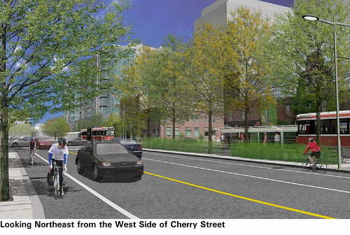
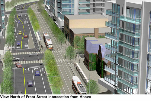
There’s an interesting streetscape experiment in the works for Cherry St. between King and Lakeshore, part of the new West Donlands development. After extensive public consultation, final plans were unveiled earlier this week that call for dedicated streetcar tracks going both ways nestled together on the east side of the street. They will be separated by a tree-lined platform from two lanes of traffic and separate bike lanes on the west side of the street, all framed by nice wide sidewalks.
This experiment will be short — only three stops — because the TTC says that the need to have traffic turning right across the streetcar tracks would otherwise slow down the streetcar too much. It’s not clear how this configuration would then transition to the rest of the streetcar route. But it’s good to see that the city, Waterfront Toronto and the TTC are open to experimenting to find a street configuration that is friendly towards both the community and sustainable transportation.
The Toronto Star has a story about this plan (and a correction).
The full details can be seen in the TTC report (PDF). Graphics of the proposed streetscape can be seen on page 16 (Thanks to Steve Munro via Nick for this link).
11 comments
Hailed as a great success????
Am I the only one who noticed that the road they are talking about is still going to be 105 feet wide? Why do we need a transit ROW for a dead-end (in the cul-de-sac sense) neighbourhood?
This area is one GIANT cul-de-sac for car traffic anyway so there wasn’t much to overcome as far as making it transit, ped and bike friendly. If you think about the site, it is hemmed in by the Don on the East side as well as the tracks and Gardiner/D.V.P. on the E and S sides. There never was going to be any N-S or E-W car traffic to begin with. This will be a great place to enjoy car-free life but it had nothing to do with planners, developers or anyone currently alive today. This area’s fate, as a forgotton corner of Corktown, was set long ago when the DVP cut the E-W rail and road access – you can still see the stumpy bridges over the Don. Let’s see the area for what it really is and not some transit miracle. A real transit miracle would be taking cars off of Queen or King for all or part of the day so when you rode the streetcar it actually got somewhere.
…or they could re-connect that broken link over the DVP and the Don for bikes, peds and streetcars only – that would be impressive
There’s a streetcar going in on Cherry St.? Where else is it goin? Where do I find out about that?
Hi Dylan,
Steve Munro pointed out that there are pictures of it in the TTC’s report, posted on their website:
http://www.ttc.ca/postings/gso-comrpt/documents/report/f3437/Streetcars_on_Cherry_Street_and_Sumach_Street_Serving_the_West_Don_Lands_Development.pdf
N.
See page 16 in the PDF linked to above for computer-generated images of how this might look.
N.
To the other Matt: these tracks aren’t a dead-end. There’s a separate process for a streetcar line on Queens Quay East that would connect these tracks to Union Station, and the plan for the Portlands area envisions Cherry Street south of the Gardiner as the transit backbone for a very large neighbourhood. It’d be all too easy to worry about planning for those connections later — and so much harder to get the right design once the area is built up.
As for the street width, it was wider in the original plan and the community input in this process reduced it. (It’s still a compromise — you can’t have a narrow street and still include all these features: bike lanes, transit ROW, car lanes, and on-street parking.) The tree line separating the tracks from the roadway is designed to break up the street so it doesn’t feel so wide.
Nice catch Matt L. Although Cherry might seem like a quiet street now, a whole new street network is part of the Precinct Plan (see Waterfront Toronto’s website for that document).There will be an additional 10,000+ residents in the West Don Lands once the plan is fully built out. The transit on Cherry will connect to the King to the north and then to the Portlands, Lower Don and Queens Quay to the south, serving the entire new waterfront neighbourhoods. Bayview Avenue is going to extend and ulitmately connect to Mill, so dont worry about north south connections.
Freaking fantastic. Finally, some new thinking on how to lay out the streetcars to benefit riders, pedestrians, shop owners… Nice to see Toronto experimenting with successful implementations in other cities.
Sorta looks like Amsterdam, which is very friendly to all forms of alternative (to car) transportation, and promotes sustainable development. Cool.
It does seem awfully wide. Is it about streetcar ROW or automobile ROW? Should any new downtown streets have a greater width than King, Queen or Parliament? Will all the new condos have parking for each resident?
@Rahul – since you mention Amsterdam – now if only we could do as CityCargo Amsterdam is doing and convert some of the current high floor streetcars to cargotrams as they are in turn replaced by new LRVs. (Electric vans take the cargo from the nearest streetcar track to the destination).
We could have streetcars and cargotrams running from Pearson to the Portlands if the Eglinton line is extended to the airport and connected to the rest of the streetcar network with the Jane line.